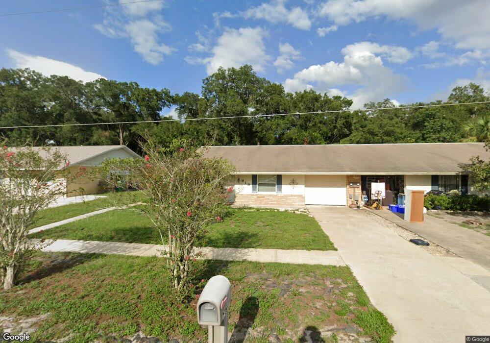
919 Marlboro Dr Deland, FL 32724
Estimated Value: $204,000 - $264,000
2
Beds
1
Bath
1,348
Sq Ft
$168/Sq Ft
Est. Value
About This Home
This home is located at 919 Marlboro Dr, Deland, FL 32724 and is currently estimated at $225,947, approximately $167 per square foot. 919 Marlboro Dr is a home with nearby schools including Deland High School, George W. Marks Elementary School, and Deland Middle School.
Ownership History
Date
Name
Owned For
Owner Type
Purchase Details
Closed on
May 28, 1999
Sold by
Hansbrough Hugh D and Hansbrough Pauline E
Bought by
Kinzer Robert W and Kinzer Sandra F
Current Estimated Value
Home Financials for this Owner
Home Financials are based on the most recent Mortgage that was taken out on this home.
Original Mortgage
$63,650
Interest Rate
6.94%
Purchase Details
Closed on
Nov 15, 1990
Bought by
Kinzer Robert W and Kinzer Sandra F
Purchase Details
Closed on
Jan 15, 1980
Bought by
Kinzer Robert W and Kinzer Sandra F
Create a Home Valuation Report for This Property
The Home Valuation Report is an in-depth analysis detailing your home's value as well as a comparison with similar homes in the area
Home Values in the Area
Average Home Value in this Area
Purchase History
| Date | Buyer | Sale Price | Title Company |
|---|---|---|---|
| Kinzer Robert W | -- | -- | |
| Kinzer Robert W | $67,000 | -- | |
| Kinzer Robert W | $73,000 | -- | |
| Kinzer Robert W | $32,500 | -- |
Source: Public Records
Mortgage History
| Date | Status | Borrower | Loan Amount |
|---|---|---|---|
| Previous Owner | Kinzer Robert W | $63,650 |
Source: Public Records
Tax History Compared to Growth
Tax History
| Year | Tax Paid | Tax Assessment Tax Assessment Total Assessment is a certain percentage of the fair market value that is determined by local assessors to be the total taxable value of land and additions on the property. | Land | Improvement |
|---|---|---|---|---|
| 2025 | $451 | $67,916 | -- | -- |
| 2024 | $451 | $66,002 | -- | -- |
| 2023 | $451 | $64,080 | $0 | $0 |
| 2022 | $449 | $62,214 | $0 | $0 |
| 2021 | $471 | $60,402 | $0 | $0 |
| 2020 | $469 | $59,568 | $0 | $0 |
| 2019 | $482 | $58,229 | $0 | $0 |
| 2018 | $495 | $57,143 | $0 | $0 |
| 2017 | $505 | $55,968 | $0 | $0 |
| 2016 | $492 | $54,817 | $0 | $0 |
| 2015 | $506 | $54,436 | $0 | $0 |
| 2014 | $515 | $54,004 | $0 | $0 |
Source: Public Records
Map
Nearby Homes
- 915 Marlboro Dr
- 907 Marlboro Dr
- 818 Eastover Cir
- 1103 Lindley Cove Cir
- 931 Azalea Walk Cir
- 927 Azalea Walk Cir
- 1150 Orangewood Ave
- 717 E Grove Place
- 753 Mystic Oaks Ln
- 708 Montreville Ave
- 851 E Pennsylvania Ave
- 1005 Crescent Pkwy
- 1007 Crescent Pkwy
- 612 E Plymouth Ave
- 605 John Thomas Ave
- 714 Astoria Dr
- 811 Grand Park Ct
- 1300 Benton Lake Dr E
- 1100 E University Ave
- 528 Compton Ct
- 917 Marlboro Dr
- 921 Marlboro Dr
- 923 Marlboro Dr
- 913 Marlboro Dr
- 925 Marlboro Dr
- 916 Marlboro Dr
- 914 Marlboro Dr
- 920 Marlboro Dr
- 927 Marlboro Dr
- 908 Marlboro Dr
- 922 Marlboro Dr
- 906 Marlboro Dr
- 911 Marlboro Dr
- 929 Marlboro Dr
- 924 Marlboro Dr
- 1075 E Plymouth Ave
- 909 Marlboro Dr
- 913 New Bedford Dr
- 915 New Bedford Dr