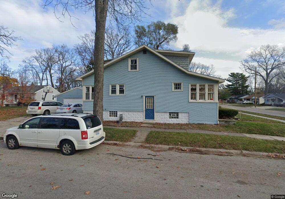
919 Sanborn St Port Huron, MI 48060
Estimated Value: $203,000 - $230,000
4
Beds
2
Baths
1,336
Sq Ft
$160/Sq Ft
Est. Value
About This Home
This home is located at 919 Sanborn St, Port Huron, MI 48060 and is currently estimated at $214,034, approximately $160 per square foot. 919 Sanborn St is a home located in St. Clair County with nearby schools including Garfield Elementary School, Holland Woods Middle School, and Port Huron Northern High School.
Ownership History
Date
Name
Owned For
Owner Type
Purchase Details
Closed on
Dec 2, 2005
Sold by
Maxon Melvin L and Maxon Beverly A
Bought by
Mcculloch Timothy A and Mcculloch Joann D
Current Estimated Value
Purchase Details
Closed on
Apr 26, 2005
Sold by
Maxon Melvin L and Maxon Beverly A
Bought by
Mcculloch Timothy A and Mcculloch Joann D
Home Financials for this Owner
Home Financials are based on the most recent Mortgage that was taken out on this home.
Original Mortgage
$27,200
Interest Rate
6.06%
Mortgage Type
Stand Alone Second
Create a Home Valuation Report for This Property
The Home Valuation Report is an in-depth analysis detailing your home's value as well as a comparison with similar homes in the area
Home Values in the Area
Average Home Value in this Area
Purchase History
| Date | Buyer | Sale Price | Title Company |
|---|---|---|---|
| Mcculloch Timothy A | -- | Huron Title Co | |
| Mcculloch Timothy A | $136,000 | None Available |
Source: Public Records
Mortgage History
| Date | Status | Borrower | Loan Amount |
|---|---|---|---|
| Previous Owner | Mcculloch Timothy A | $27,200 |
Source: Public Records
Tax History
| Year | Tax Paid | Tax Assessment Tax Assessment Total Assessment is a certain percentage of the fair market value that is determined by local assessors to be the total taxable value of land and additions on the property. | Land | Improvement |
|---|---|---|---|---|
| 2025 | $2,111 | $94,500 | $0 | $0 |
| 2024 | $2,058 | $86,900 | $0 | $0 |
| 2023 | $1,944 | $76,900 | $0 | $0 |
| 2022 | $2,054 | $68,400 | $0 | $0 |
| 2020 | $1,972 | $61,500 | $61,500 | $0 |
| 2019 | $1,936 | $53,300 | $0 | $0 |
| 2018 | $1,893 | $53,300 | $0 | $0 |
| 2017 | $1,690 | $48,600 | $0 | $0 |
| 2016 | $1,448 | $48,600 | $0 | $0 |
| 2015 | $1,421 | $43,200 | $43,200 | $0 |
| 2014 | $1,421 | $39,700 | $39,700 | $0 |
| 2013 | -- | $39,000 | $0 | $0 |
Source: Public Records
Map
Nearby Homes
- 817 Florida Ave
- 3513 Stone St
- 3455 Gratiot Ave
- 810 Holland Ave Unit 2
- 3165 10th Ave
- 3142 Wright St
- 2915 10th Ave
- 3506 Holland Park Ln
- 1211 Myrtle St
- 3444 Riverside Dr
- 3316 Hickory Ln
- 910 Church St
- 2835 17th Ave
- 3218 Monticello Dr
- 2431 Armour St
- 2308 Brandywine Ln
- 2400 Stone St Unit 2414
- 2215 Hancock St
- 2525 19th Ave
- 4033 Helen Ave
- 3300 Walnut St
- 911 Sanborn St
- 1001 Sanborn St
- 1005 Sanborn St
- 3314 Walnut St Unit Bldg-Unit
- 3314 Walnut St
- 914 Sanborn St
- 901 Sanborn St
- 910 Sanborn St
- 3318 Walnut St
- 3225 Walnut St
- 820 Sanborn St
- 3307 Walnut St
- 3320 Walnut St
- 1013 Sanborn St
- 3325 Walnut St
- 816 Sanborn St
- 1014 Sanborn St
- 821 Sanborn St
- 3221 Walnut St
Your Personal Tour Guide
Ask me questions while you tour the home.