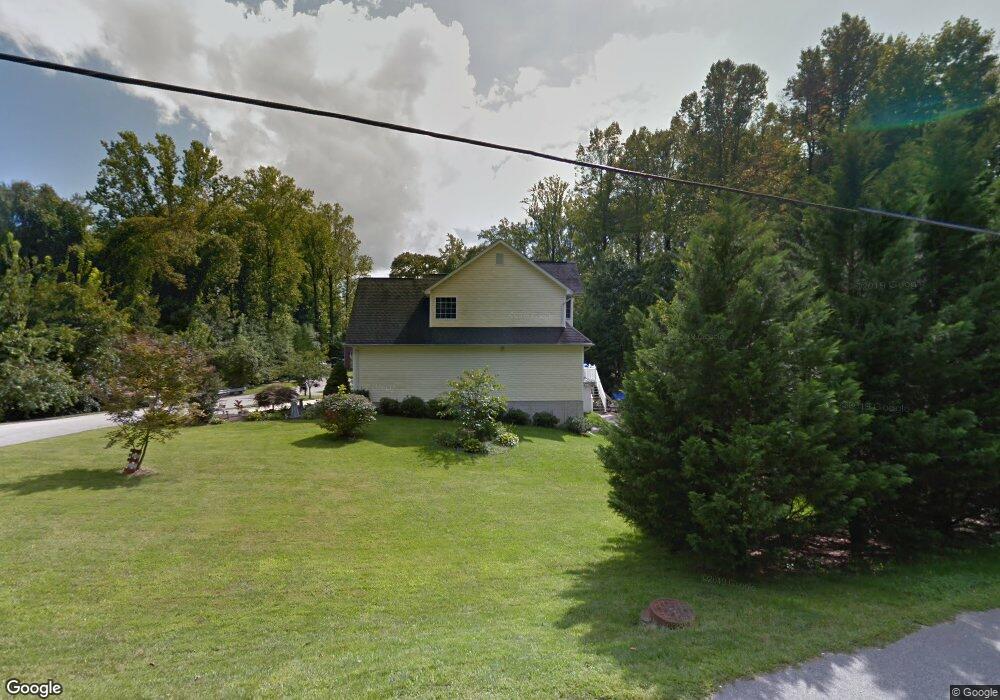
92 Clifford Blvd Annapolis, MD 21401
Estimated Value: $710,855 - $752,000
--
Bed
3
Baths
2,203
Sq Ft
$330/Sq Ft
Est. Value
About This Home
This home is located at 92 Clifford Blvd, Annapolis, MD 21401 and is currently estimated at $727,964, approximately $330 per square foot. 92 Clifford Blvd is a home located in Anne Arundel County with nearby schools including Rolling Knolls Elementary School, Wiley H. Bates Middle School, and Annapolis High School.
Ownership History
Date
Name
Owned For
Owner Type
Purchase Details
Closed on
Mar 20, 2025
Sold by
Vazquez Eduardo and Vazquez Vickie A
Bought by
Boricwa Family Trust and Vazquez
Current Estimated Value
Purchase Details
Closed on
Mar 19, 2003
Sold by
Clifford Matthew V
Bought by
Vazquez Eduardo and Vazquez Vickie A
Create a Home Valuation Report for This Property
The Home Valuation Report is an in-depth analysis detailing your home's value as well as a comparison with similar homes in the area
Home Values in the Area
Average Home Value in this Area
Purchase History
| Date | Buyer | Sale Price | Title Company |
|---|---|---|---|
| Boricwa Family Trust | -- | None Listed On Document | |
| Boricwa Family Trust | -- | None Listed On Document | |
| Vazquez Eduardo | $93,950 | -- |
Source: Public Records
Mortgage History
| Date | Status | Borrower | Loan Amount |
|---|---|---|---|
| Closed | Vazquez Eduardo | -- |
Source: Public Records
Tax History Compared to Growth
Tax History
| Year | Tax Paid | Tax Assessment Tax Assessment Total Assessment is a certain percentage of the fair market value that is determined by local assessors to be the total taxable value of land and additions on the property. | Land | Improvement |
|---|---|---|---|---|
| 2025 | $5,772 | $575,267 | -- | -- |
| 2024 | $5,772 | $542,133 | $0 | $0 |
| 2023 | $5,601 | $509,000 | $206,200 | $302,800 |
| 2022 | $5,247 | $502,433 | $0 | $0 |
| 2021 | $10,312 | $495,867 | $0 | $0 |
| 2020 | $5,028 | $489,300 | $206,200 | $283,100 |
| 2019 | $4,948 | $485,467 | $0 | $0 |
| 2018 | $4,884 | $481,633 | $0 | $0 |
| 2017 | $4,663 | $477,800 | $0 | $0 |
| 2016 | -- | $462,633 | $0 | $0 |
| 2015 | -- | $447,467 | $0 | $0 |
| 2014 | -- | $432,300 | $0 | $0 |
Source: Public Records
Map
Nearby Homes
- 1807 Green Top Ct
- 551 Defense Hwy
- 1809 Labrott Ln
- 1909 Eleanor Ct
- 1907 Mackiebeth Ct
- 905 Beacon Way
- 1945 Marconi Cir
- 2507 Tudo Ct
- 901 Sextant Way
- 2664 Compass Dr
- 1007 Boom Ct
- 825 Coxswain Way
- 2601 Compass Dr
- 2600 Compass Dr
- 802 Bridgeport Way
- 1012 Mastline Dr
- 2671 Cunningham Hole Rd
- 934 Chesterfield Rd
- 2737 Yeomans Lantern Ct
- 1003 Mastline Dr
- 94 Clifford Blvd
- 514 Defense Hwy
- 512 Defense Hwy
- 520 Defense Hwy
- 521 Defense Hwy
- 98 Clifford Blvd
- 509 Defense Hwy
- 522 Defense Hwy Unit A
- 522 Defense Hwy
- 522 Defense Hwy Unit B
- 522 Defense Hwy Unit C
- 7 1st St
- 5 1st St
- 524 Defense Hwy
- 529 Defense Hwy
- 9 1st St
- 3 1st St Unit A1
- 3 1st St
- 4 Southaven Rd
- 11 1st St