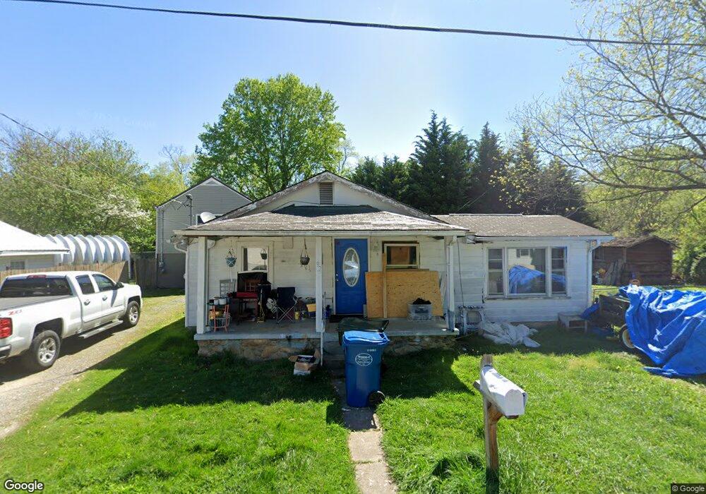
92 Franklin St Waynesville, NC 28786
Estimated Value: $107,000 - $244,000
2
Beds
1
Bath
990
Sq Ft
$172/Sq Ft
Est. Value
About This Home
This home is located at 92 Franklin St, Waynesville, NC 28786 and is currently estimated at $170,188, approximately $171 per square foot. 92 Franklin St is a home located in Haywood County with nearby schools including Hazelwood Elementary, Waynesville Middle, and Tuscola High.
Ownership History
Date
Name
Owned For
Owner Type
Purchase Details
Closed on
Aug 12, 2024
Sold by
Boyd William Richard
Bought by
Champion Credit Union
Current Estimated Value
Purchase Details
Closed on
Dec 11, 2020
Sold by
Sutton Kathy H
Bought by
Sartori Anthony L and Sartori Natasha Collins
Home Financials for this Owner
Home Financials are based on the most recent Mortgage that was taken out on this home.
Original Mortgage
$81,000
Interest Rate
4.38%
Mortgage Type
New Conventional
Purchase Details
Closed on
Dec 9, 2020
Sold by
Sutton Kathy H and Beasley Stanley
Bought by
Sartori Anthony L and Sartori Natasha Collins
Home Financials for this Owner
Home Financials are based on the most recent Mortgage that was taken out on this home.
Original Mortgage
$81,000
Interest Rate
4.38%
Mortgage Type
New Conventional
Create a Home Valuation Report for This Property
The Home Valuation Report is an in-depth analysis detailing your home's value as well as a comparison with similar homes in the area
Home Values in the Area
Average Home Value in this Area
Purchase History
| Date | Buyer | Sale Price | Title Company |
|---|---|---|---|
| Champion Credit Union | $90,753 | None Listed On Document | |
| Sartori Anthony L | $69,000 | None Listed On Document | |
| Sartori Anthony L | $69,000 | None Available |
Source: Public Records
Mortgage History
| Date | Status | Borrower | Loan Amount |
|---|---|---|---|
| Previous Owner | Sartori Anthony L | $81,000 | |
| Previous Owner | Sartori Anthony L | $81,000 |
Source: Public Records
Tax History Compared to Growth
Tax History
| Year | Tax Paid | Tax Assessment Tax Assessment Total Assessment is a certain percentage of the fair market value that is determined by local assessors to be the total taxable value of land and additions on the property. | Land | Improvement |
|---|---|---|---|---|
| 2025 | -- | $79,300 | $14,700 | $64,600 |
| 2024 | $555 | $72,000 | $11,000 | $61,000 |
| 2023 | $555 | $72,000 | $11,000 | $61,000 |
| 2022 | $544 | $72,000 | $11,000 | $61,000 |
| 2021 | $544 | $72,000 | $11,000 | $61,000 |
| 2020 | $439 | $47,900 | $9,200 | $38,700 |
| 2019 | $444 | $47,900 | $9,200 | $38,700 |
| 2018 | $444 | $47,900 | $9,200 | $38,700 |
| 2017 | $444 | $47,900 | $0 | $0 |
| 2016 | $428 | $46,700 | $0 | $0 |
| 2015 | $428 | $46,700 | $0 | $0 |
| 2014 | $345 | $46,700 | $0 | $0 |
Source: Public Records
Map
Nearby Homes
- 55 Polk St
- 90 Camp Branch Rd
- 72 Raines Blvd
- 142 Country Club Dr
- 0 Alex Trail
- 55 Scates St
- 00 Longview Dr Unit 6
- 00 Longview Dr Unit 7
- 00 Longview Dr Unit 8
- 165 Country Club Dr
- 271 Brook St
- 49 Robinson St
- 35 Essex Rd
- 171 Surrey Rd
- 87 Willow Rd Unit C-2
- 87 Willow Rd Unit D-16
- 419 Country Club Dr
- 228 Hyatt St
- 0 Pinewood Dr Unit 5
- 25 Pinewood Dr