D
Seller's Agent in 2026
DeWolfe Group
Gibson Sothebys International Realty
(781) 248-1534
2 in this area
41 Total Sales
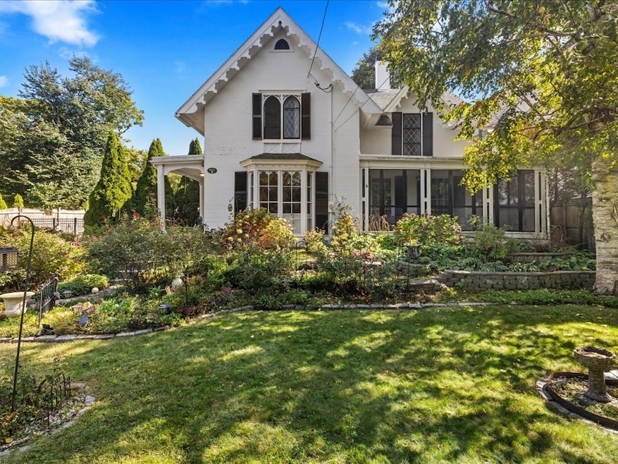

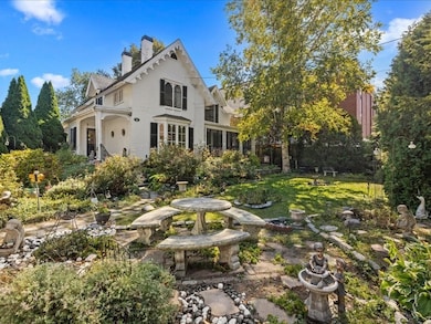
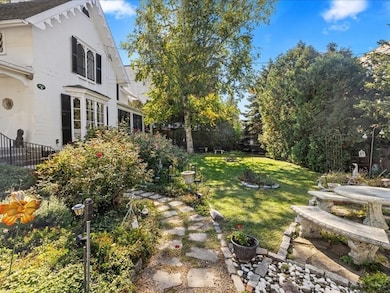
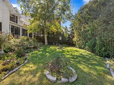


Step back in time with this enchanting American Gothic Revival home, where timeless craftsmanship meets modern comfort in the heart of Dedham’s Square/ Upper Dedham. Distinguished architectural details arched doorways, decorative moldings, and rich hardwood floors infuse every room with character and warmth. The flexible floor plan includes elegant living and dining rooms with fireplaces and French doors, a spacious kitchen with stone counters, stainless appliances, and an inviting island perfect for gatherings. The vaulted family room with beams and skylight adds a touch of drama and light. Upstairs, four generous bedrooms and two full baths provide room for everyone. Enjoy peaceful moments on the wraparound screened porch overlooking vibrant gardens and a private, fenced yard. With central air, ample parking, and proximity to Dedham Square shops, parks, train, and highway access this one-of-a-kind home beautifully blends history, charm, and livability.
Last Agent to Sell the Property
Gibson Sotheby's International Realty Listed on: 10/14/2025

We collect this data history from publicly available records. To have your information removed, we recommend requesting removal directly through your county’s website.
| Date | Type | Sale Price | Title Company |
|---|---|---|---|
| Quit Claim Deed | $800,000 | -- | |
| Deed | -- | -- |
We collect this data history from publicly available records. To have your information removed, we recommend requesting removal directly through your county’s website.
| Date | Status | Loan Amount | Loan Type |
|---|---|---|---|
| Open | $1,170,000 | Purchase Money Mortgage | |
| Previous Owner | $300,300 | No Value Available | |
| Previous Owner | $240,000 | No Value Available | |
| Previous Owner | $240,000 | No Value Available |
| Date | Event | Price | List to Sale | Price per Sq Ft |
|---|---|---|---|---|
| 04/01/2026 04/01/26 | Sold | $800,000 | -19.6% | $311 / Sq Ft |
| 03/02/2026 03/02/26 | Pending | -- | -- | -- |
| 12/29/2025 12/29/25 | Price Changed | $995,000 | -9.5% | $387 / Sq Ft |
| 12/19/2025 12/19/25 | For Sale | $1,100,000 | 0.0% | $428 / Sq Ft |
| 12/05/2025 12/05/25 | Pending | -- | -- | -- |
| 10/14/2025 10/14/25 | For Sale | $1,100,000 | -- | $428 / Sq Ft |
| Year | Tax Paid | Tax Assessment Tax Assessment Total Assessment is a certain percentage of the fair market value that is determined by local assessors to be the total taxable value of land and additions on the property. | Land | Improvement |
|---|---|---|---|---|
| 2025 | $12,850 | $1,018,200 | $346,400 | $671,800 |
| 2024 | $12,573 | $1,005,800 | $314,300 | $691,500 |
| 2023 | $11,901 | $926,900 | $284,600 | $642,300 |
| 2022 | $10,839 | $811,900 | $267,300 | $544,600 |
| 2021 | $9,976 | $729,800 | $247,400 | $482,400 |
| 2020 | $10,009 | $729,500 | $247,300 | $482,200 |
| 2019 | $9,707 | $686,000 | $215,100 | $470,900 |
| 2018 | $9,385 | $645,000 | $187,900 | $457,100 |
| 2017 | $10,150 | $687,700 | $175,900 | $511,800 |
| 2016 | $9,585 | $618,800 | $162,800 | $456,000 |
| 2015 | $8,667 | $546,100 | $162,400 | $383,700 |
| 2014 | $8,550 | $531,700 | $159,400 | $372,300 |
D
Seller's Agent in 2026
DeWolfe Group
Gibson Sothebys International Realty
(781) 248-1534
2 in this area
41 Total Sales
Seller Co-Listing Agent in 2026
Tammy Dewolfe
Gibson Sothebys International Realty
(781) 248-1534
2 in this area
52 Total Sales
Buyer's Agent in 2026
Nicoletta Longo
Century 21 Cityside
(617) 797-5043
1 in this area
32 Total Sales
Source: MLS Property Information Network (MLS PIN)
MLS Number: 73443360
APN: DEDH-000092-000000-000025
Disclaimer: Certain information contained herein is derived from information provided by parties other than Homes.com. All information provided is deemed reliable, but is not guaranteed to be accurate and should be independently verified.
![]() The property listing data and information, or the Images, set forth herein were provided to MLS Property Information Network, Inc. from third party sources, including sellers, lessors and public records, and were compiled by MLS Property Information Network, Inc. The property listing data and information, and the Images, are for the personal, non-commercial use of consumers having a good faith interest in purchasing or leasing listed properties of the type displayed to them and may not be used for any purpose other than to identify prospective properties which such consumers may have a good faith interest in purchasing or leasing. MLS Property Information Network, Inc. and its subscribers disclaim any and all representations and warranties as to the accuracy of the property listing data and information, or as to the accuracy of any of the Images, set forth herein.
The property listing data and information, or the Images, set forth herein were provided to MLS Property Information Network, Inc. from third party sources, including sellers, lessors and public records, and were compiled by MLS Property Information Network, Inc. The property listing data and information, and the Images, are for the personal, non-commercial use of consumers having a good faith interest in purchasing or leasing listed properties of the type displayed to them and may not be used for any purpose other than to identify prospective properties which such consumers may have a good faith interest in purchasing or leasing. MLS Property Information Network, Inc. and its subscribers disclaim any and all representations and warranties as to the accuracy of the property listing data and information, or as to the accuracy of any of the Images, set forth herein.
Ask me questions while you tour the home.