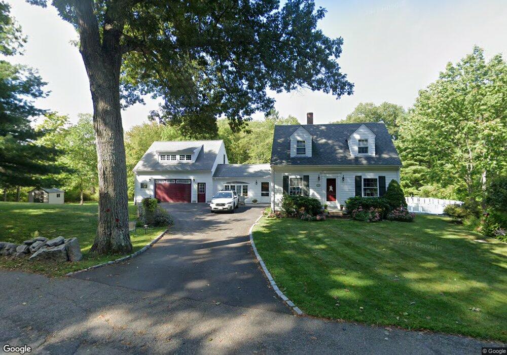
92 Thurston St Wrentham, MA 02093
Estimated Value: $642,000 - $785,000
3
Beds
2
Baths
2,042
Sq Ft
$345/Sq Ft
Est. Value
About This Home
This home is located at 92 Thurston St, Wrentham, MA 02093 and is currently estimated at $703,634, approximately $344 per square foot. 92 Thurston St is a home located in Norfolk County with nearby schools including Delaney Elementary School, Charles E Roderick, and Foxborough Regional Charter School.
Ownership History
Date
Name
Owned For
Owner Type
Purchase Details
Closed on
May 17, 1999
Sold by
Pignato Joseph A and Pignato Kathleen P
Bought by
Munn Timothy P and Munn Lisa M
Current Estimated Value
Home Financials for this Owner
Home Financials are based on the most recent Mortgage that was taken out on this home.
Original Mortgage
$179,400
Interest Rate
6.92%
Mortgage Type
Purchase Money Mortgage
Purchase Details
Closed on
Aug 1, 1991
Sold by
Czyrklis Eileen
Bought by
Pignato Joseph A
Create a Home Valuation Report for This Property
The Home Valuation Report is an in-depth analysis detailing your home's value as well as a comparison with similar homes in the area
Home Values in the Area
Average Home Value in this Area
Purchase History
| Date | Buyer | Sale Price | Title Company |
|---|---|---|---|
| Munn Timothy P | $195,000 | -- | |
| Pignato Joseph A | $153,500 | -- |
Source: Public Records
Mortgage History
| Date | Status | Borrower | Loan Amount |
|---|---|---|---|
| Open | Pignato Joseph A | $264,000 | |
| Closed | Pignato Joseph A | $264,000 | |
| Closed | Pignato Joseph A | $179,400 |
Source: Public Records
Tax History Compared to Growth
Tax History
| Year | Tax Paid | Tax Assessment Tax Assessment Total Assessment is a certain percentage of the fair market value that is determined by local assessors to be the total taxable value of land and additions on the property. | Land | Improvement |
|---|---|---|---|---|
| 2025 | $6,910 | $596,200 | $273,500 | $322,700 |
| 2024 | $6,619 | $551,600 | $273,500 | $278,100 |
| 2023 | $6,660 | $527,700 | $248,600 | $279,100 |
| 2022 | $6,214 | $454,600 | $223,700 | $230,900 |
| 2021 | $6,015 | $427,500 | $199,900 | $227,600 |
| 2020 | $5,947 | $417,300 | $182,400 | $234,900 |
| 2019 | $5,558 | $393,600 | $165,800 | $227,800 |
| 2018 | $4,994 | $350,700 | $166,000 | $184,700 |
| 2017 | $4,888 | $343,000 | $162,800 | $180,200 |
| 2016 | $4,365 | $305,700 | $158,100 | $147,600 |
| 2015 | $4,349 | $290,300 | $152,000 | $138,300 |
| 2014 | $4,345 | $283,800 | $146,200 | $137,600 |
Source: Public Records
Map
Nearby Homes
- 362 East St
- 65 Pond St
- 1 Lorraine Metcalf Dr
- 270 Dedham St
- 120 Hawes St
- 483 Thurston St
- 10 Nature View Dr
- 15 Nature View Dr
- 319 Taunton St
- 25 Foxboro Rd
- 11 Earle Stewart Ln
- 131 Creek St Unit 7
- Lot 3 - 14 Earle Stewart Ln
- Lot 1 - Blueberry 2 Car Plan at King Philip Estates
- Lot 8 - Blueberry 2 Car Plan at King Philip Estates
- Lot 5 - Hughes 2 car Plan at King Philip Estates
- Lot 6 - Blueberry 3 Car Plan at King Philip Estates
- Lot 2 - Camden 2 Car Plan at King Philip Estates
- Lot 7 - Cedar Plan at King Philip Estates
- Lot 4 - Hemingway 2 Car Plan at King Philip Estates