
Seller's Agent in 2025
Charles Petitti
Coldwell Banker Realty - Newton
(617) 969-3200
11 Total Sales
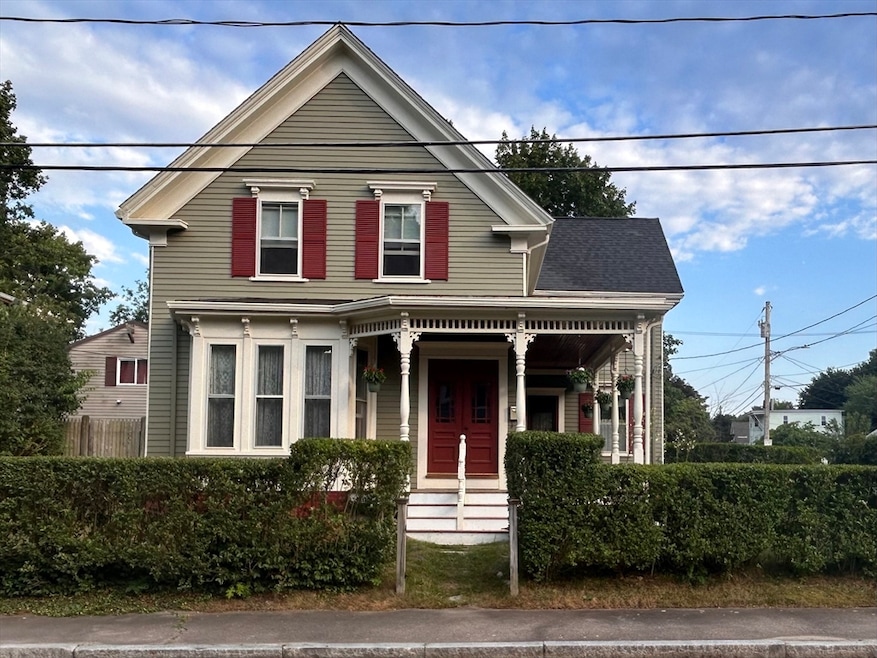


SUNFILLED VICTORIAN FARMHOUSE ON QUIET STREET ON NORTH SIDE OF BROCKTON, COMPLETLY RESTORED BY MASTER CRAFTSMAN W/LOTS OF CUSTOM ORNATE DETAILED TRIM THRU-OUT INTERIOR & EXTERIOR, UPDATED GRANITE KITCHEN WITH S/S FRIDGE & STOVE, D/WASHER HAS PANEL TO MATCH KITCHEN CABINETS, KITCHEN ALSO HAS RECESSED LIGHTS, CEILING FAN & POT RACK, TOTAL 4 BEDROOMS, 2 PRIMARY BEDROOMS ON 2ND FLOOR BOTH WITH WALK IN CLOSETS W/BUILT IN'S, ONE HAS PRIVATE 2ND FLOOR REAR PORCH DECK THAT OVERLOOKS BACK YARD & OTHER HAS ORNATE MANTEL, 2ND FLOOR LAUNDRY W/STACKABLE W&D INCLUDED, LARGE FRONT WRAP AROUND FARMERS PORCH, ENTIRE EXTERIOR WAS JUST PROFESSIONALLY PAINTED IN 3 COLOR VICTORIAN STYLE, NEWER ROOF INSTALLED RECENTLY, LARGE LEVEL FULLY FENCE ENCLOSED & GATED YARD W/PATIO & 8X10 SHED, HOUSE WAS PREVIOUSLY USED AS A 2 FAMILY & STILL HAS 2 FUNTIONING ELECTRIC METERS & CIRCUIT BREAKER PANELS, ALSO 2 GAS METER FITS IN BASEMENT(ONLY ONE IS BEING USED RIGHT NOW) POSSIBLE 2 FAMILY OR ADU CONVERSION. A MUST SEE !!
Last Agent to Sell the Property
Coldwell Banker Realty - Newton Listed on: 07/04/2025
| Date | Type | Sale Price | Title Company |
|---|---|---|---|
| Quit Claim Deed | $550,000 | -- | |
| Land Court Massachusetts | -- | -- | |
| Land Court Massachusetts | -- | -- | |
| Leasehold Conv With Agreement Of Sale Fee Purchase Hawaii | $32,000 | -- | |
| Leasehold Conv With Agreement Of Sale Fee Purchase Hawaii | $32,000 | -- |
| Date | Status | Loan Amount | Loan Type |
|---|---|---|---|
| Open | $531,643 | FHA | |
| Previous Owner | $7,500 | No Value Available | |
| Previous Owner | $51,000 | No Value Available | |
| Previous Owner | $50,500 | No Value Available |
| Date | Event | Price | List to Sale | Price per Sq Ft |
|---|---|---|---|---|
| 09/24/2025 09/24/25 | Sold | $550,000 | -3.5% | $341 / Sq Ft |
| 08/10/2025 08/10/25 | Pending | -- | -- | -- |
| 07/31/2025 07/31/25 | Price Changed | $569,900 | -4.2% | $353 / Sq Ft |
| 07/20/2025 07/20/25 | Price Changed | $595,000 | -4.8% | $369 / Sq Ft |
| 07/15/2025 07/15/25 | Price Changed | $624,900 | -3.8% | $387 / Sq Ft |
| 07/04/2025 07/04/25 | For Sale | $649,900 | -- | $403 / Sq Ft |
| Year | Tax Paid | Tax Assessment Tax Assessment Total Assessment is a certain percentage of the fair market value that is determined by local assessors to be the total taxable value of land and additions on the property. | Land | Improvement |
|---|---|---|---|---|
| 2025 | $3,625 | $299,300 | $140,100 | $159,200 |
| 2024 | $3,569 | $296,900 | $140,100 | $156,800 |
| 2023 | $3,476 | $267,800 | $104,200 | $163,600 |
| 2022 | $3,856 | $276,000 | $94,700 | $181,300 |
| 2021 | $3,553 | $245,000 | $78,700 | $166,300 |
| 2020 | $3,354 | $221,400 | $73,700 | $147,700 |
| 2019 | $3,249 | $209,100 | $71,900 | $137,200 |
| 2018 | $2,891 | $180,000 | $71,900 | $108,100 |
| 2017 | $2,813 | $174,700 | $71,900 | $102,800 |
| 2016 | $2,456 | $141,500 | $69,700 | $71,800 |
| 2015 | $2,276 | $125,400 | $69,700 | $55,700 |
| 2014 | $2,177 | $120,100 | $69,700 | $50,400 |
Seller's Agent in 2025
Charles Petitti
Coldwell Banker Realty - Newton
(617) 969-3200
11 Total Sales
Buyer's Agent in 2025
Michael Mitchell
Littleton Realty Group
(646) 745-5648
11 Total Sales
Source: MLS Property Information Network (MLS PIN)
MLS Number: 73399738
APN: BROC-000098-000038
Disclaimer: Certain information contained herein is derived from information provided by parties other than Homes.com. All information provided is deemed reliable, but is not guaranteed to be accurate and should be independently verified.
![]() The property listing data and information, or the Images, set forth herein were provided to MLS Property Information Network, Inc. from third party sources, including sellers, lessors and public records, and were compiled by MLS Property Information Network, Inc. The property listing data and information, and the Images, are for the personal, non-commercial use of consumers having a good faith interest in purchasing or leasing listed properties of the type displayed to them and may not be used for any purpose other than to identify prospective properties which such consumers may have a good faith interest in purchasing or leasing. MLS Property Information Network, Inc. and its subscribers disclaim any and all representations and warranties as to the accuracy of the property listing data and information, or as to the accuracy of any of the Images, set forth herein.
The property listing data and information, or the Images, set forth herein were provided to MLS Property Information Network, Inc. from third party sources, including sellers, lessors and public records, and were compiled by MLS Property Information Network, Inc. The property listing data and information, and the Images, are for the personal, non-commercial use of consumers having a good faith interest in purchasing or leasing listed properties of the type displayed to them and may not be used for any purpose other than to identify prospective properties which such consumers may have a good faith interest in purchasing or leasing. MLS Property Information Network, Inc. and its subscribers disclaim any and all representations and warranties as to the accuracy of the property listing data and information, or as to the accuracy of any of the Images, set forth herein.
Ask me questions while you tour the home.