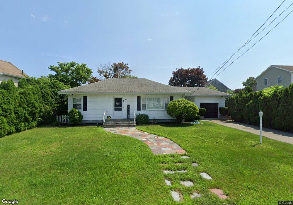
92 Winterville Rd New Bedford, MA 02740
The South End NeighborhoodEstimated Value: $308,000 - $413,000
3
Beds
1
Bath
1,171
Sq Ft
$326/Sq Ft
Est. Value
About This Home
This home is located at 92 Winterville Rd, New Bedford, MA 02740 and is currently estimated at $381,244, approximately $325 per square foot. 92 Winterville Rd is a home located in Bristol County with nearby schools including Betsey B. Winslow Elementary School, Keith Middle School, and New Bedford High School.
Ownership History
Date
Name
Owned For
Owner Type
Purchase Details
Closed on
Mar 13, 2008
Sold by
Wells Fargo Fncl Mass
Bought by
Tibbals Timothy K
Current Estimated Value
Purchase Details
Closed on
Nov 16, 2007
Sold by
Doucet Cynthia M and Doucet Daniel
Bought by
Wells Fargo Fncl Mass
Purchase Details
Closed on
Apr 20, 1995
Sold by
Dunham Cecilia Est and Howard
Bought by
Doucet Daniel and Doucet Cynthia M
Create a Home Valuation Report for This Property
The Home Valuation Report is an in-depth analysis detailing your home's value as well as a comparison with similar homes in the area
Home Values in the Area
Average Home Value in this Area
Purchase History
| Date | Buyer | Sale Price | Title Company |
|---|---|---|---|
| Tibbals Timothy K | $120,000 | -- | |
| Tibbals Timothy K | $120,000 | -- | |
| Wells Fargo Fncl Mass | $247,130 | -- | |
| Wells Fargo Fncl Mass | $247,130 | -- | |
| Doucet Daniel | $80,000 | -- | |
| Doucet Daniel | $80,000 | -- |
Source: Public Records
Mortgage History
| Date | Status | Borrower | Loan Amount |
|---|---|---|---|
| Previous Owner | Doucet Daniel | $218,614 | |
| Previous Owner | Doucet Daniel | $152,000 |
Source: Public Records
Tax History Compared to Growth
Tax History
| Year | Tax Paid | Tax Assessment Tax Assessment Total Assessment is a certain percentage of the fair market value that is determined by local assessors to be the total taxable value of land and additions on the property. | Land | Improvement |
|---|---|---|---|---|
| 2025 | $3,856 | $340,900 | $102,200 | $238,700 |
| 2024 | $3,659 | $304,900 | $103,900 | $201,000 |
| 2023 | $3,868 | $270,700 | $89,600 | $181,100 |
| 2022 | $3,563 | $229,300 | $85,100 | $144,200 |
| 2021 | $2,994 | $222,400 | $85,100 | $137,300 |
| 2020 | $3,321 | $205,500 | $85,100 | $120,400 |
| 2019 | $3,271 | $198,600 | $85,100 | $113,500 |
| 2018 | $3,063 | $184,200 | $85,100 | $99,100 |
| 2017 | $2,879 | $172,500 | $85,100 | $87,400 |
| 2016 | $2,755 | $167,100 | $85,100 | $82,000 |
| 2015 | $2,550 | $162,100 | $85,100 | $77,000 |
| 2014 | $2,344 | $154,600 | $80,000 | $74,600 |
Source: Public Records
Map
Nearby Homes
- 0 Winterville Rd (Ss)
- 83 Alden St
- 88 Winterville Rd
- 98 Winterville Rd
- 91 Winterville Rd
- 93 Winterville Rd
- 71 Winterville Rd Unit 73
- 70 Winterville Rd
- 69 Alden St
- 56 Schofield St
- 96 Alden St
- 101 Winterville Rd
- 112 Winterville Rd
- 84 Alden St
- 70 Alden St
- 92 Alden St
- 107 Winterville Rd
- 63 Winterville Rd Unit 65
- 62 Winterville Rd
- 57 Alden St