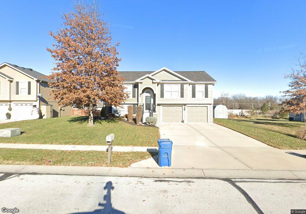
920 E 8th Cir Kearney, MO 64060
Estimated Value: $338,038 - $361,000
3
Beds
3
Baths
1,340
Sq Ft
$263/Sq Ft
Est. Value
About This Home
This home is located at 920 E 8th Cir, Kearney, MO 64060 and is currently estimated at $352,010, approximately $262 per square foot. 920 E 8th Cir is a home located in Clay County with nearby schools including Kearney Junior High School and Kearney High School.
Ownership History
Date
Name
Owned For
Owner Type
Purchase Details
Closed on
Aug 27, 2015
Sold by
Wemhoff Phillip J and Wemhoff Angela L
Bought by
Wemhoff Phillip J and Wemhoff Angela L
Current Estimated Value
Purchase Details
Closed on
Jun 16, 2010
Sold by
C King Homes L L C
Bought by
Wemhoff Phillip J and Wemhoff Angela L
Home Financials for this Owner
Home Financials are based on the most recent Mortgage that was taken out on this home.
Original Mortgage
$160,075
Outstanding Balance
$107,072
Interest Rate
4.93%
Mortgage Type
New Conventional
Estimated Equity
$244,938
Purchase Details
Closed on
Sep 4, 2009
Sold by
King Clarence and King Norma Ann
Bought by
C King Homes Llc
Home Financials for this Owner
Home Financials are based on the most recent Mortgage that was taken out on this home.
Original Mortgage
$139,000
Interest Rate
5.26%
Mortgage Type
Construction
Create a Home Valuation Report for This Property
The Home Valuation Report is an in-depth analysis detailing your home's value as well as a comparison with similar homes in the area
Home Values in the Area
Average Home Value in this Area
Purchase History
| Date | Buyer | Sale Price | Title Company |
|---|---|---|---|
| Wemhoff Phillip J | -- | None Available | |
| Wemhoff Phillip J | -- | None Available | |
| C King Homes Llc | -- | None Available |
Source: Public Records
Mortgage History
| Date | Status | Borrower | Loan Amount |
|---|---|---|---|
| Open | Wemhoff Phillip J | $160,075 | |
| Previous Owner | C King Homes Llc | $139,000 |
Source: Public Records
Tax History
| Year | Tax Paid | Tax Assessment Tax Assessment Total Assessment is a certain percentage of the fair market value that is determined by local assessors to be the total taxable value of land and additions on the property. | Land | Improvement |
|---|---|---|---|---|
| 2025 | $3,085 | $50,750 | -- | -- |
| 2024 | $3,085 | $45,010 | -- | -- |
| 2023 | $3,074 | $45,010 | $0 | $0 |
| 2022 | $2,700 | $38,230 | $0 | $0 |
| 2021 | $2,647 | $38,228 | $4,180 | $34,048 |
| 2020 | $2,701 | $35,490 | $0 | $0 |
| 2019 | $2,687 | $35,492 | $4,180 | $31,312 |
| 2018 | $2,582 | $32,930 | $0 | $0 |
| 2017 | $2,458 | $32,930 | $4,180 | $28,750 |
| 2016 | $2,458 | $31,690 | $4,180 | $27,510 |
| 2015 | $2,458 | $31,690 | $4,180 | $27,510 |
| 2014 | $2,404 | $30,840 | $4,370 | $26,470 |
Source: Public Records
Map
Nearby Homes
- 905 Susan St
- 1202 Noah's Ln
- 1204 Noah's Ln
- 1209 Noah's Ln
- 1307 Stonecrest Dr
- 623 E 13th St
- 1300 Melissa Ct
- 201 S Marimack Dr
- 1300 Robin Cir
- 200 E 10th St
- 402 E 14th St
- 1210 E 15th St
- 1207 E 15th St
- 1710 Rockwater Ln
- 1304 S Jefferson St
- 709 Feldspar St
- 1003 Madelyn Dr
- 1102 Melody Ct
- 1818 Lauren Ln
- 303 W 11th St
Your Personal Tour Guide
Ask me questions while you tour the home.