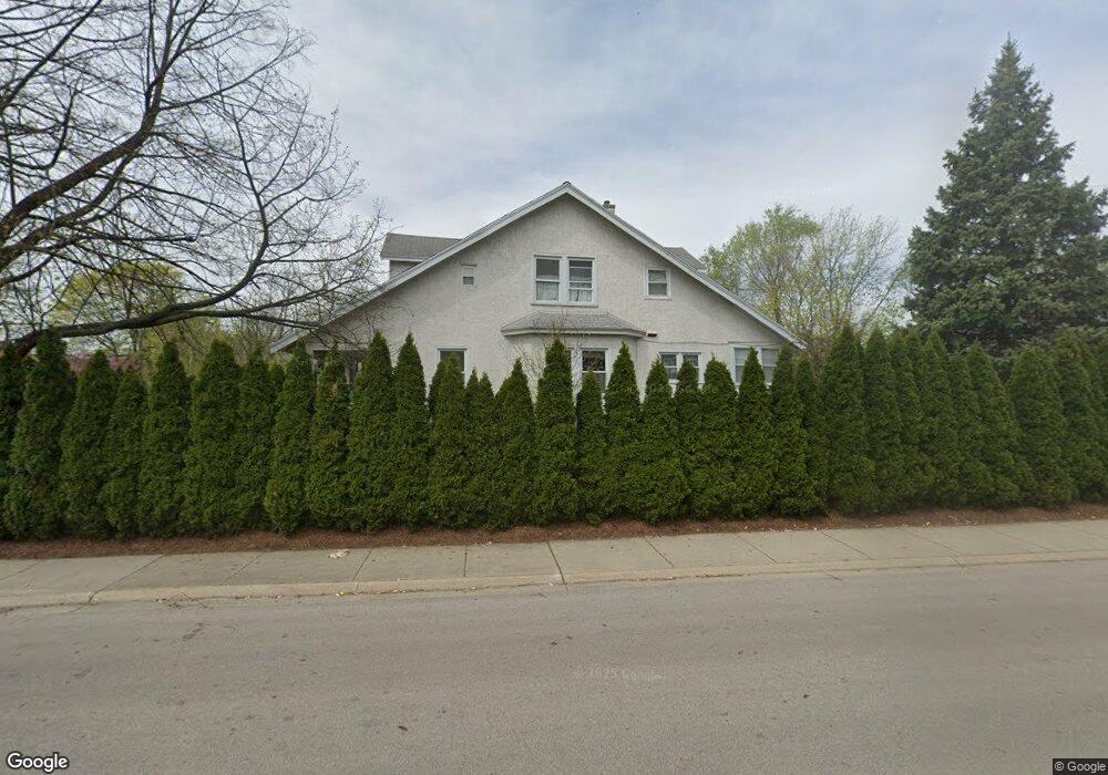
9200 Central Park Ave Evanston, IL 60203
North Skokie NeighborhoodEstimated Value: $556,000 - $643,256
3
Beds
3
Baths
1,654
Sq Ft
$365/Sq Ft
Est. Value
About This Home
This home is located at 9200 Central Park Ave, Evanston, IL 60203 and is currently estimated at $604,314, approximately $365 per square foot. 9200 Central Park Ave is a home located in Cook County with nearby schools including Walker Elementary School, Chute Middle School, and Evanston Township High School.
Ownership History
Date
Name
Owned For
Owner Type
Purchase Details
Closed on
Jul 23, 1996
Sold by
Jung Carol Lynn and Jung Nicholas John
Bought by
Hruska Robert and Kormosova Danka
Current Estimated Value
Home Financials for this Owner
Home Financials are based on the most recent Mortgage that was taken out on this home.
Original Mortgage
$138,000
Outstanding Balance
$10,146
Interest Rate
8.43%
Estimated Equity
$594,168
Create a Home Valuation Report for This Property
The Home Valuation Report is an in-depth analysis detailing your home's value as well as a comparison with similar homes in the area
Home Values in the Area
Average Home Value in this Area
Purchase History
| Date | Buyer | Sale Price | Title Company |
|---|---|---|---|
| Hruska Robert | $172,500 | Rei Title |
Source: Public Records
Mortgage History
| Date | Status | Borrower | Loan Amount |
|---|---|---|---|
| Open | Hruska Robert | $138,000 |
Source: Public Records
Tax History Compared to Growth
Tax History
| Year | Tax Paid | Tax Assessment Tax Assessment Total Assessment is a certain percentage of the fair market value that is determined by local assessors to be the total taxable value of land and additions on the property. | Land | Improvement |
|---|---|---|---|---|
| 2024 | $10,950 | $52,000 | $11,627 | $40,373 |
| 2023 | $10,468 | $52,000 | $11,627 | $40,373 |
| 2022 | $10,468 | $52,000 | $11,627 | $40,373 |
| 2021 | $8,925 | $40,211 | $6,976 | $33,235 |
| 2020 | $8,890 | $40,211 | $6,976 | $33,235 |
| 2019 | $8,764 | $44,188 | $6,976 | $37,212 |
| 2018 | $8,609 | $38,001 | $5,979 | $32,022 |
| 2017 | $8,442 | $38,001 | $5,979 | $32,022 |
| 2016 | $8,450 | $38,001 | $5,979 | $32,022 |
| 2015 | $6,640 | $29,573 | $5,149 | $24,424 |
| 2014 | $6,592 | $29,573 | $5,149 | $24,424 |
| 2013 | $6,490 | $29,573 | $5,149 | $24,424 |
Source: Public Records
Map
Nearby Homes
- 3500 Church St Unit 204
- 9101 Sleeping Bear Rd
- 8950 Ewing Ave
- 8822 Central Park Ave
- 8822 Forestview Rd
- 1633 Mcdaniel Ave
- 2113 Forestview Rd
- 2022 Mcdaniel Ave
- 8728 Trumbull Ave
- 8713 Drake Ave
- 3639 Crain St
- 2221 Lincolnwood Dr
- 1808 Laurel Ave
- 2440 Simpson St
- 2633 Crawford Ave
- 1311 Mcdaniel Ave Unit C
- 3358 Dempster St
- 8607 Lawndale Ave
- 8613 Trumbull Ave
- 9628 Keystone Ave
- 3608 Church St
- 3614 Church St
- 9216 Central Park Ave
- 9216 Central Park Ave
- 3618 Church St
- 9201 Central Park Ave
- 9209 Central Park Ave
- 9215 Central Park Ave
- 9224 Central Park Ave
- 9155 Central Park Ave
- 3553 Church St
- 9230 Central Park Ave
- 9200 Drake Ave
- 3549 Church St
- 9208 Drake Ave
- 9235 Central Park Ave
- 9214 Drake Ave
- 9220 Drake Ave
- 3545 Church St