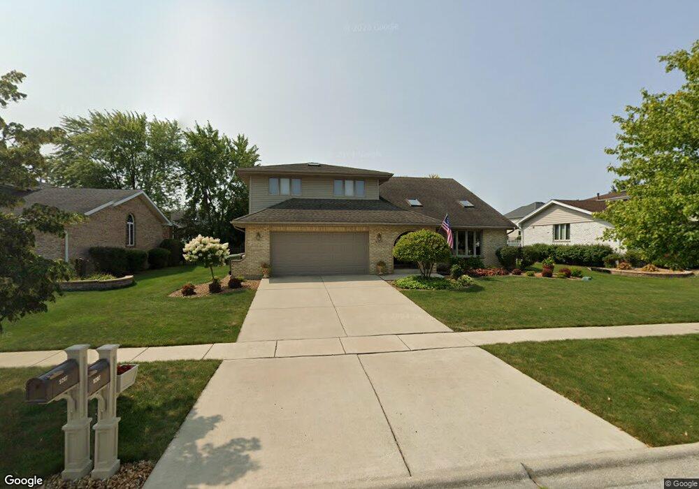
9207 178th St Tinley Park, IL 60487
Central Tinley Park NeighborhoodEstimated Value: $473,000 - $544,000
4
Beds
3
Baths
3,266
Sq Ft
$158/Sq Ft
Est. Value
About This Home
This home is located at 9207 178th St, Tinley Park, IL 60487 and is currently estimated at $516,661, approximately $158 per square foot. 9207 178th St is a home located in Cook County with nearby schools including Christa Mcauliffe School, Prairie View Middle School, and Victor J Andrew High School.
Ownership History
Date
Name
Owned For
Owner Type
Purchase Details
Closed on
Nov 30, 2004
Sold by
Franchetti Daniel R
Bought by
Franchetti Laurie
Current Estimated Value
Purchase Details
Closed on
Sep 16, 1997
Sold by
Tallant Daniel T and Tallant Janet J
Bought by
Franchetti Daniel R and Franchetti Laurie
Home Financials for this Owner
Home Financials are based on the most recent Mortgage that was taken out on this home.
Original Mortgage
$192,500
Outstanding Balance
$30,253
Interest Rate
7.63%
Estimated Equity
$486,408
Create a Home Valuation Report for This Property
The Home Valuation Report is an in-depth analysis detailing your home's value as well as a comparison with similar homes in the area
Home Values in the Area
Average Home Value in this Area
Purchase History
| Date | Buyer | Sale Price | Title Company |
|---|---|---|---|
| Franchetti Laurie | -- | -- | |
| Franchetti Daniel R | $166,666 | -- |
Source: Public Records
Mortgage History
| Date | Status | Borrower | Loan Amount |
|---|---|---|---|
| Open | Franchetti Daniel R | $192,500 |
Source: Public Records
Tax History Compared to Growth
Tax History
| Year | Tax Paid | Tax Assessment Tax Assessment Total Assessment is a certain percentage of the fair market value that is determined by local assessors to be the total taxable value of land and additions on the property. | Land | Improvement |
|---|---|---|---|---|
| 2024 | $11,296 | $39,464 | $5,400 | $34,064 |
| 2023 | $9,722 | $44,000 | $5,400 | $38,600 |
| 2022 | $9,722 | $30,690 | $4,725 | $25,965 |
| 2021 | $9,440 | $30,690 | $4,725 | $25,965 |
| 2020 | $9,271 | $30,690 | $4,725 | $25,965 |
| 2019 | $9,330 | $32,199 | $4,275 | $27,924 |
| 2018 | $9,877 | $34,555 | $4,275 | $30,280 |
| 2017 | $9,632 | $34,555 | $4,275 | $30,280 |
| 2016 | $10,327 | $33,590 | $3,825 | $29,765 |
| 2015 | $10,175 | $33,590 | $3,825 | $29,765 |
| 2014 | $10,105 | $33,590 | $3,825 | $29,765 |
| 2013 | $8,430 | $30,543 | $3,825 | $26,718 |
Source: Public Records
Map
Nearby Homes
- 9313 178th St
- 17964 Upland Dr
- 9280 Windsor Pkwy Unit 92
- 17594 Windsor Pkwy Unit 58
- 9395 Windsor Pkwy Unit 163
- 17595 Drummond Dr Unit 139
- 17533 Pecan Ln
- 9201 175th St
- 9421 Quail Crossing
- 9334 Drummond Dr Unit 3
- 18055 Upland Dr
- 17535 S La Grange Rd
- 17535-2 Lagrange Rd
- 17412 Briar Dr
- 9058 Newcastle Ct
- 18248 Murphy Cir Unit 182
- 17500 Lagrange Rd
- 9038 Mansfield Dr Unit 8
- 18233 Murphy Cir Unit 182
- 17631 Dover Ct
- 9213 178th St
- 9201 178th St
- 9224 Greenwood Dr
- 9218 Greenwood Dr
- 9151 178th St
- 9219 178th St
- 9230 Greenwood Dr
- 17741 Ash St
- 9212 Greenwood Dr
- 9218 178th St
- 9236 Greenwood Dr
- 9143 178th St
- 9225 178th St
- 9150 178th St
- 17733 Ash St
- 9206 Greenwood Dr
- 17730 Ash St
- 9224 178th St
- 9144 178th St
- 9137 178th St