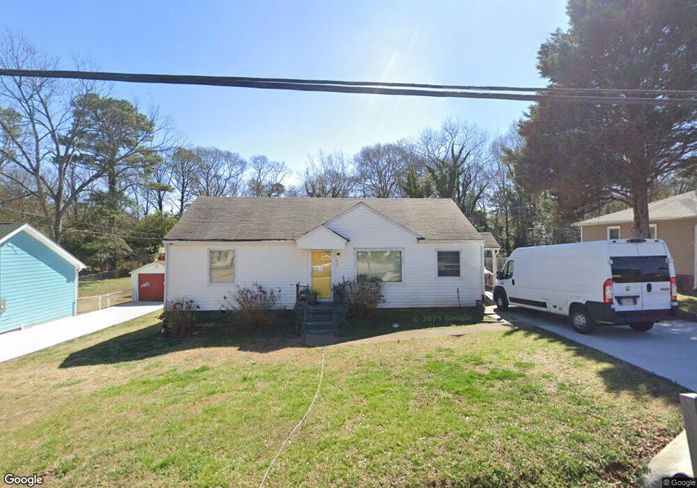
921 Astor Ave Forest Park, GA 30297
Estimated Value: $206,881 - $274,000
4
Beds
3
Baths
1,836
Sq Ft
$128/Sq Ft
Est. Value
About This Home
This home is located at 921 Astor Ave, Forest Park, GA 30297 and is currently estimated at $234,970, approximately $127 per square foot. 921 Astor Ave is a home located in Clayton County with nearby schools including Forest Park Middle School, Forest Park High School, and Forest Park Christian School.
Ownership History
Date
Name
Owned For
Owner Type
Purchase Details
Closed on
May 29, 2020
Sold by
White James Irma
Bought by
Peek Tania S and Peek Terry N
Current Estimated Value
Home Financials for this Owner
Home Financials are based on the most recent Mortgage that was taken out on this home.
Original Mortgage
$137,365
Outstanding Balance
$121,764
Interest Rate
3.2%
Mortgage Type
FHA
Estimated Equity
$113,206
Purchase Details
Closed on
Dec 7, 2011
Sold by
Federal National Mortgage Association
Bought by
White James Irma
Purchase Details
Closed on
May 3, 2011
Sold by
Wells Fargo Bk Na
Bought by
Federal Natl Mtg Assn Fnma
Create a Home Valuation Report for This Property
The Home Valuation Report is an in-depth analysis detailing your home's value as well as a comparison with similar homes in the area
Home Values in the Area
Average Home Value in this Area
Purchase History
| Date | Buyer | Sale Price | Title Company |
|---|---|---|---|
| Peek Tania S | $139,900 | -- | |
| White James Irma | $18,000 | -- | |
| Federal Natl Mtg Assn Fnma | -- | -- | |
| Wells Fargo Bk Na | $96,575 | -- |
Source: Public Records
Mortgage History
| Date | Status | Borrower | Loan Amount |
|---|---|---|---|
| Open | Peek Tania S | $137,365 |
Source: Public Records
Tax History Compared to Growth
Tax History
| Year | Tax Paid | Tax Assessment Tax Assessment Total Assessment is a certain percentage of the fair market value that is determined by local assessors to be the total taxable value of land and additions on the property. | Land | Improvement |
|---|---|---|---|---|
| 2024 | $3,035 | $87,040 | $3,200 | $83,840 |
| 2023 | $2,654 | $83,040 | $3,200 | $79,840 |
| 2022 | $1,783 | $51,680 | $3,200 | $48,480 |
| 2021 | $1,358 | $39,080 | $3,200 | $35,880 |
| 2020 | $1,061 | $30,232 | $10,000 | $20,232 |
| 2019 | $1,025 | $28,793 | $10,000 | $18,793 |
| 2018 | $1,046 | $29,385 | $10,000 | $19,385 |
| 2017 | $844 | $23,658 | $10,000 | $13,658 |
| 2016 | $881 | $24,682 | $10,000 | $14,682 |
| 2015 | $765 | $0 | $0 | $0 |
| 2014 | $722 | $20,759 | $10,000 | $10,759 |
Source: Public Records
Map
Nearby Homes
- 4899 College St
- 4871 College St
- 4705 Ernest Dr
- 4694 Ernest Dr
- 1083 Grace Dr
- 784 Springvalley Dr
- 864 Northview Dr
- 1048 Ferguson Ct
- 1126 Grace Dr
- 1132 Grace Dr Unit 3
- 0 Hill St Unit 10563105
- 888 Hill St
- 1101 Lloyd Dr
- 681 Barksdale Dr
- 0 Robin Ln Unit 10544125
- 946 Main St
- 904 Main St
- 701 Forest Pkwy
- 4637 Hendrix Dr
- 5002 Park Ave
- 921 Astor Ave Unit /44
- 927 Astor Ave
- 915 Astor Ave
- 935 Astor Ave
- 907 Astor Ave
- 4675 Mitchell St
- 0 Mitchell St Unit 8579710
- 0 Mitchell St Unit 8425862
- 0 Mitchell St Unit 9048866
- 0 Mitchell St Unit 7155862
- 0 Mitchell St Unit 7180815
- 0 Mitchell St Unit 7305818
- 4685 Mitchell St
- 4684 College St
- 918 Astor Ave
- 926 Astor Ave
- 934 Astor Ave
- 908 Astor Ave
- 892 Dennis Dr
- 4659 College St