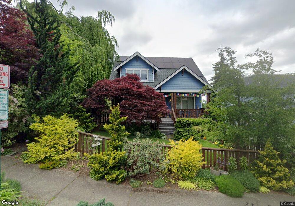
921 Jersey St Bellingham, WA 98225
Sehome NeighborhoodEstimated Value: $975,000 - $1,227,000
4
Beds
4
Baths
2,213
Sq Ft
$488/Sq Ft
Est. Value
About This Home
This home is located at 921 Jersey St, Bellingham, WA 98225 and is currently estimated at $1,079,659, approximately $487 per square foot. 921 Jersey St is a home located in Whatcom County with nearby schools including Happy Valley Elementary School, Fairhaven Middle School, and Sehome High School.
Ownership History
Date
Name
Owned For
Owner Type
Purchase Details
Closed on
Jun 8, 2004
Sold by
Timmins Barbara J
Bought by
Parrish Clark
Current Estimated Value
Create a Home Valuation Report for This Property
The Home Valuation Report is an in-depth analysis detailing your home's value as well as a comparison with similar homes in the area
Home Values in the Area
Average Home Value in this Area
Purchase History
| Date | Buyer | Sale Price | Title Company |
|---|---|---|---|
| Parrish Clark | $100,000 | Stewart Title Company |
Source: Public Records
Tax History Compared to Growth
Tax History
| Year | Tax Paid | Tax Assessment Tax Assessment Total Assessment is a certain percentage of the fair market value that is determined by local assessors to be the total taxable value of land and additions on the property. | Land | Improvement |
|---|---|---|---|---|
| 2024 | $8,113 | $1,016,955 | $493,117 | $523,838 |
| 2023 | $8,113 | $1,042,847 | $505,672 | $537,175 |
| 2022 | $6,413 | $883,786 | $428,544 | $455,242 |
| 2021 | $6,292 | $690,458 | $334,800 | $355,658 |
| 2020 | $5,746 | $639,313 | $310,000 | $329,313 |
| 2019 | $5,413 | $564,281 | $244,200 | $320,081 |
| 2018 | $5,453 | $532,959 | $230,769 | $302,190 |
| 2017 | $4,748 | $459,058 | $198,330 | $260,728 |
| 2016 | $4,243 | $417,756 | $180,345 | $237,411 |
| 2015 | $4,253 | $388,660 | $170,115 | $218,545 |
| 2014 | -- | $376,974 | $165,000 | $211,974 |
| 2013 | -- | $367,692 | $159,300 | $208,392 |
Source: Public Records
Map
Nearby Homes
- 615 E Myrtle St
- 616 E Myrtle St
- 1126 N Forest St
- 901 N Forest St Unit 107
- 901 N Forest St Unit 125
- 901 N Forest St Unit 109
- 1309 Billy Frank Jr St
- 1205 E Maple St
- 1001 N State St Unit 403
- 1031 N State St Unit 107
- 1031 N State St Unit 209
- 310 E Ivy St
- 1125 Otis St
- 1234 Grant St
- 1015 Railroad Ave Unit 418
- 1342 Franklin St
- 1335 Humboldt St
- 5 XX Gladstone St
- 500 Gladstone St
- 508 Gladstone St
- 927 Jersey St
- 915 Jersey St
- 931 Jersey St
- 922 Billy Frank Jr St
- 922 Indian St
- 911 Jersey St
- 914 Indian St
- 924 Billy Frank Jr St
- 926 Indian St
- 912 Indian St
- 930 Indian St
- 920 Jersey St
- 800 E Laurel St
- 924 Jersey St
- 916 Jersey St
- 910 Billy Frank Jr St
- 905 Jersey St
- 910 Indian St
- 918 Billy Frank Jr St
- 914 Jersey St