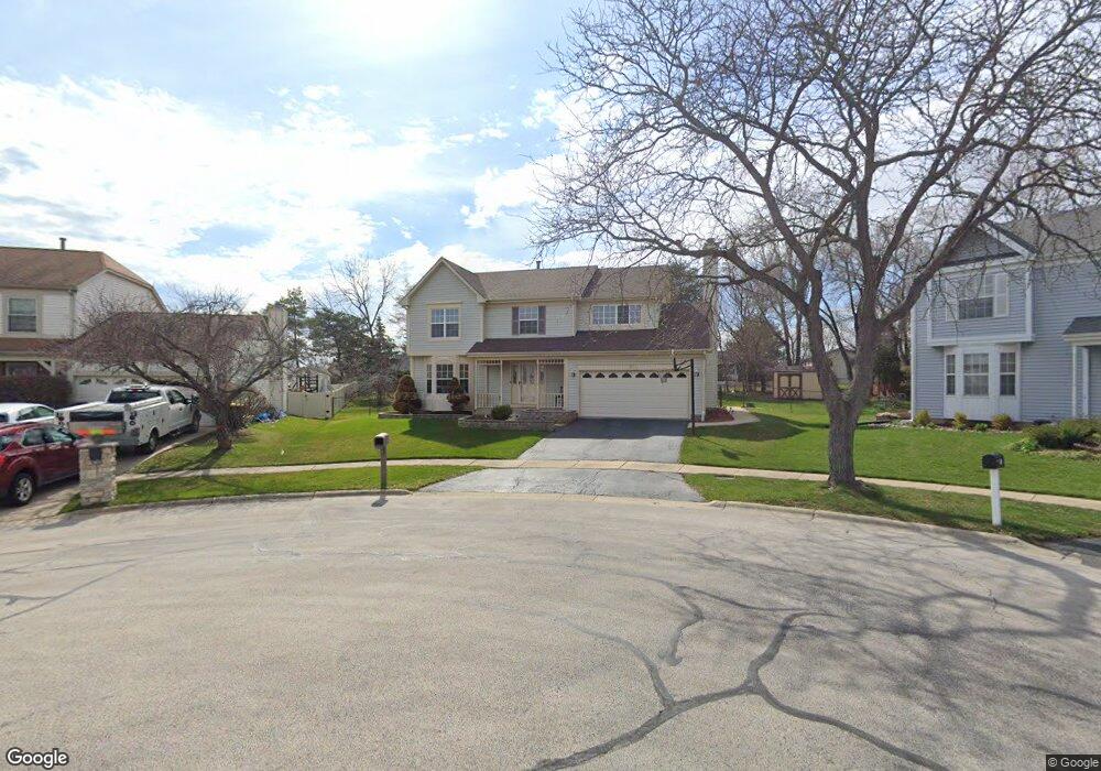
921 Paddock Dr Carol Stream, IL 60188
Estimated Value: $484,990 - $536,000
4
Beds
3
Baths
2,253
Sq Ft
$225/Sq Ft
Est. Value
About This Home
This home is located at 921 Paddock Dr, Carol Stream, IL 60188 and is currently estimated at $507,748, approximately $225 per square foot. 921 Paddock Dr is a home located in DuPage County with nearby schools including Heritage Lakes Elementary School, Jay Stream Middle School, and Glenbard North High School.
Ownership History
Date
Name
Owned For
Owner Type
Purchase Details
Closed on
Apr 7, 2025
Sold by
Ajanee Nadir S
Bought by
Nadir Shah Ajanee Revocable Trust and Ajanee
Current Estimated Value
Purchase Details
Closed on
May 1, 2010
Sold by
Ajanee Nadir S and Ajanee Rozina
Bought by
Ajanee Nadir S
Home Financials for this Owner
Home Financials are based on the most recent Mortgage that was taken out on this home.
Original Mortgage
$248,000
Interest Rate
5.14%
Mortgage Type
New Conventional
Create a Home Valuation Report for This Property
The Home Valuation Report is an in-depth analysis detailing your home's value as well as a comparison with similar homes in the area
Home Values in the Area
Average Home Value in this Area
Purchase History
| Date | Buyer | Sale Price | Title Company |
|---|---|---|---|
| Nadir Shah Ajanee Revocable Trust | -- | None Listed On Document | |
| Ajanee Nadir S | -- | Citywide Title Corporation |
Source: Public Records
Mortgage History
| Date | Status | Borrower | Loan Amount |
|---|---|---|---|
| Previous Owner | Ajanee Nadir S | $248,000 |
Source: Public Records
Tax History
| Year | Tax Paid | Tax Assessment Tax Assessment Total Assessment is a certain percentage of the fair market value that is determined by local assessors to be the total taxable value of land and additions on the property. | Land | Improvement |
|---|---|---|---|---|
| 2024 | -- | $135,681 | $38,434 | $97,247 |
| 2023 | $10,289 | $123,100 | $34,870 | $88,230 |
| 2022 | $10,003 | $114,410 | $32,410 | $82,000 |
| 2021 | $9,534 | $108,610 | $30,770 | $77,840 |
| 2020 | $10,094 | $113,500 | $31,420 | $82,080 |
| 2019 | $9,724 | $109,450 | $30,300 | $79,150 |
| 2018 | $9,155 | $104,730 | $28,990 | $75,740 |
| 2017 | $8,980 | $100,550 | $27,830 | $72,720 |
| 2016 | $8,817 | $96,040 | $26,580 | $69,460 |
| 2015 | $8,754 | $90,910 | $25,160 | $65,750 |
| 2014 | $8,662 | $88,600 | $24,520 | $64,080 |
| 2013 | $8,610 | $90,730 | $25,110 | $65,620 |
Source: Public Records
Map
Nearby Homes
- 1060 Cliff View Ln
- 880 Hampton Dr
- 770 Birchbark Trail
- 909 Hampton Dr
- 1112 Woodlake Dr
- 736 Cypress Ln
- 1116 Evergreen Dr
- 1279 Bison Trail
- 1266 Seabury Cir
- 1239 Spring Valley Dr
- 1325 Gloucester Cir
- 1308 Coldspring Rd Unit 7
- 1179 Edington Ct
- 554 Alton Ct Unit 224
- 1360 Rose Ave
- 3758 Merrimac Ln W
- 545 Alton Ct Unit 273
- 553 Alton Ct Unit 2113
- 514 Alton Ct Unit 2
- 427 W Army Trail Rd
Your Personal Tour Guide
Ask me questions while you tour the home.