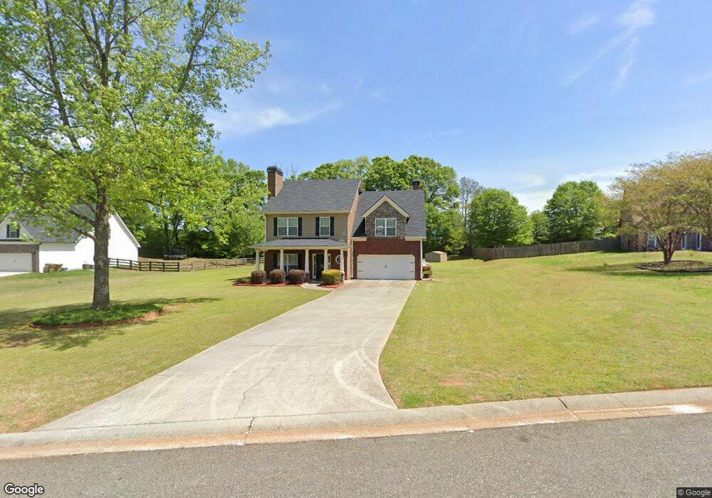
922 Mckendree Ln Bethlehem, GA 30620
Estimated Value: $321,000 - $378,000
Studio
3
Baths
1,922
Sq Ft
$179/Sq Ft
Est. Value
About This Home
This home is located at 922 Mckendree Ln, Bethlehem, GA 30620 and is currently estimated at $343,643, approximately $178 per square foot. 922 Mckendree Ln is a home located in Barrow County with nearby schools including Bethlehem Elementary School, Haymon-Morris Middle School, and Apalachee High School.
Ownership History
Date
Name
Owned For
Owner Type
Purchase Details
Closed on
Jan 6, 2006
Sold by
Castles & Kingdoms Inc
Bought by
Arzuaga Isabel
Current Estimated Value
Home Financials for this Owner
Home Financials are based on the most recent Mortgage that was taken out on this home.
Original Mortgage
$31,000
Interest Rate
5.82%
Mortgage Type
Stand Alone Refi Refinance Of Original Loan
Purchase Details
Closed on
Aug 18, 2004
Sold by
Mckendree Llc
Bought by
Castles & Kingdoms Homes Inc
Purchase Details
Closed on
Mar 10, 2004
Bought by
Mckendree Llc
Create a Home Valuation Report for This Property
The Home Valuation Report is an in-depth analysis detailing your home's value as well as a comparison with similar homes in the area
Home Values in the Area
Average Home Value in this Area
Purchase History
| Date | Buyer | Sale Price | Title Company |
|---|---|---|---|
| Arzuaga Isabel | $155,000 | -- | |
| Castles & Kingdoms Homes Inc | $38,500 | -- | |
| Mckendree Llc | -- | -- |
Source: Public Records
Mortgage History
| Date | Status | Borrower | Loan Amount |
|---|---|---|---|
| Closed | Arzuaga Isabel | $31,000 |
Source: Public Records
Tax History
| Year | Tax Paid | Tax Assessment Tax Assessment Total Assessment is a certain percentage of the fair market value that is determined by local assessors to be the total taxable value of land and additions on the property. | Land | Improvement |
|---|---|---|---|---|
| 2025 | $747 | $96,494 | $21,600 | $74,894 |
| 2024 | $2,351 | $94,478 | $21,600 | $72,878 |
| 2023 | $1,947 | $94,878 | $21,600 | $73,278 |
| 2022 | $2,431 | $85,101 | $21,600 | $63,501 |
| 2021 | $2,207 | $73,129 | $17,200 | $55,929 |
| 2020 | $2,207 | $73,129 | $17,200 | $55,929 |
| 2019 | $2,244 | $73,129 | $17,200 | $55,929 |
| 2018 | $2,065 | $68,081 | $17,200 | $50,881 |
| 2017 | $1,575 | $54,090 | $17,200 | $36,890 |
| 2016 | $1,559 | $52,655 | $17,200 | $35,455 |
| 2015 | $1,578 | $53,044 | $17,200 | $35,844 |
| 2014 | $1,313 | $43,878 | $7,644 | $36,234 |
| 2013 | -- | $41,574 | $7,644 | $33,930 |
Source: Public Records
Map
Nearby Homes
- 0 J B Owens Lot 2 09ac Rd
- 0 J B Owens Lot 3 2 01ac Rd
- 404 Tanners Bridge Rd
- 1071 Covenant Ct
- 0 J B Owens Rd Unit CL348952
- 0 J B Owens Rd Unit 10690069
- 763 Moss Side Dr
- 204 Lynn Rd
- 3243 Lowell Rd
- 511 Grand Oaks Ave
- 3233 Lowell Rd
- 3153 Lowell Rd
- 3283 Lowell Rd
- 1101 Ravenwood Dr
- 454 Grant Ct
- 220 Carl Bethlehem Rd SW
- 0 Tanners Bridge Cir Unit 10536031
- 825 Arch Tanner Rd
- 476 Tanners Bridge Cir Unit 1
- 154 Blissful Ln
- 920 Mckendree Ln
- 924 Mckendree Ln Unit Lot 11
- 924 Mckendree Ln
- 918 Mckendree Ln
- 926 Mckendree Ln
- 927 Mckendree Ln
- 925 Mckendree Ln
- 916 Mckendree Ln
- 265 Lokeys Cir
- 164 Lokeys Cir
- 242 Lokeys Cir
- 280 Lokeys Cir
- 145 Lokeys Cir
- 106 Lokeys Cir
- 214 Lokeys Cir
- 128 Lokeys Cir
- 262 Lokeys Cir
- 196 Lokeys Cir
- 167 Lokeys Cir Unit 11
- 187 Lokeys Cir Unit 12
Your Personal Tour Guide
Ask me questions while you tour the home.