Estimated Value: $729,268 - $847,000
3
Beds
2
Baths
2,344
Sq Ft
$344/Sq Ft
Est. Value
About This Home
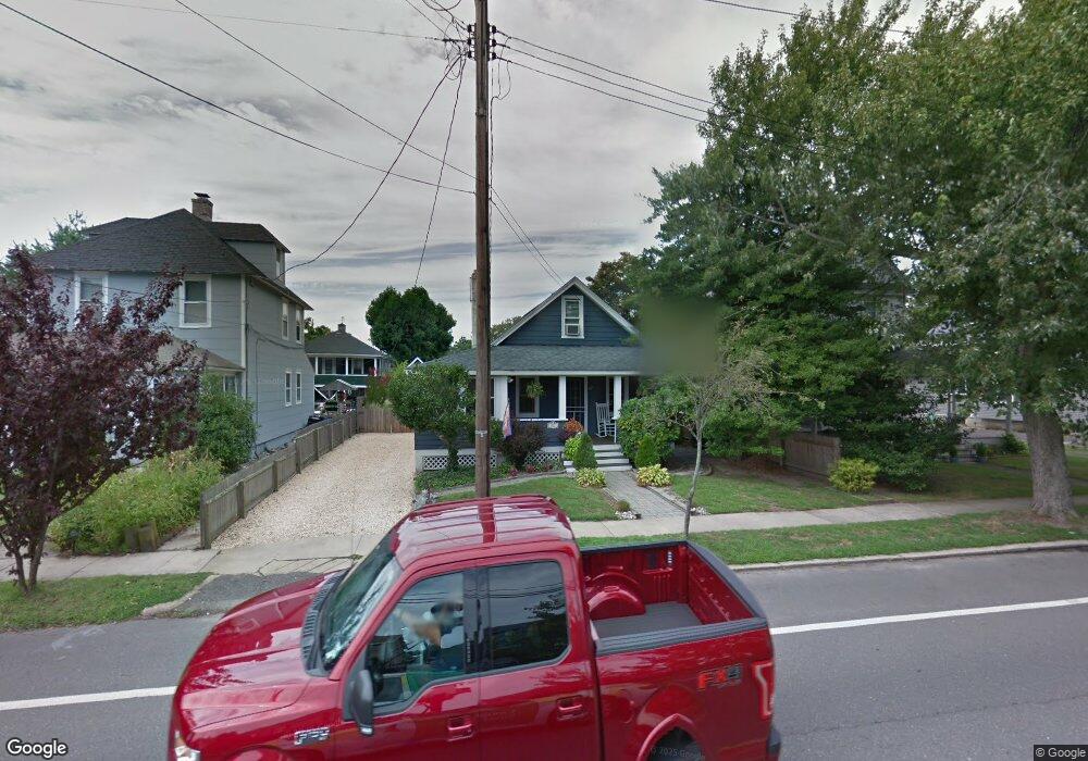
This home is located at 923 Bay Ave, Point Pleasant Beach, NJ 08742 and is currently estimated at $806,067, approximately $343 per square foot. 923 Bay Ave is a home located in Ocean County with nearby schools including G Harold Antrim Elementary School, Point Pleasant Beach High School, and St. Peter School.
Ownership History
Date
Name
Owned For
Owner Type
Purchase Details
Closed on
Feb 25, 2016
Sold by
Moyse John T and Moyse Abigaile Winkle
Bought by
Moyse Joh T and Moyse Abigaile Winkel
Current Estimated Value
Home Financials for this Owner
Home Financials are based on the most recent Mortgage that was taken out on this home.
Original Mortgage
$255,000
Outstanding Balance
$196,514
Interest Rate
2.88%
Mortgage Type
New Conventional
Estimated Equity
$609,553
Purchase Details
Closed on
Sep 8, 2006
Sold by
Brookes Sally H and Brookes Margaret Ann
Bought by
Moyse John T and Winkle Abigaile J
Home Financials for this Owner
Home Financials are based on the most recent Mortgage that was taken out on this home.
Original Mortgage
$255,000
Interest Rate
6.47%
Mortgage Type
Purchase Money Mortgage
Create a Home Valuation Report for This Property
The Home Valuation Report is an in-depth analysis detailing your home's value as well as a comparison with similar homes in the area
Home Values in the Area
Average Home Value in this Area
Purchase History
| Date | Buyer | Sale Price | Title Company |
|---|---|---|---|
| Moyse Joh T | -- | -- | |
| Moyse John T | $405,000 | None Available |
Source: Public Records
Mortgage History
| Date | Status | Borrower | Loan Amount |
|---|---|---|---|
| Open | Moyse Joh T | $255,000 | |
| Previous Owner | Moyse John T | $255,000 |
Source: Public Records
Tax History Compared to Growth
Tax History
| Year | Tax Paid | Tax Assessment Tax Assessment Total Assessment is a certain percentage of the fair market value that is determined by local assessors to be the total taxable value of land and additions on the property. | Land | Improvement |
|---|---|---|---|---|
| 2025 | $5,872 | $341,800 | $249,000 | $92,800 |
| 2024 | $5,694 | $341,800 | $249,000 | $92,800 |
| 2023 | $5,534 | $341,800 | $249,000 | $92,800 |
| 2022 | $5,534 | $341,800 | $249,000 | $92,800 |
| 2021 | $5,411 | $341,800 | $249,000 | $92,800 |
| 2020 | $5,404 | $341,800 | $249,000 | $92,800 |
| 2019 | $5,329 | $341,800 | $249,000 | $92,800 |
| 2018 | $5,247 | $341,800 | $249,000 | $92,800 |
| 2017 | $5,165 | $341,800 | $249,000 | $92,800 |
| 2016 | $5,189 | $341,800 | $249,000 | $92,800 |
| 2015 | $5,148 | $341,800 | $249,000 | $92,800 |
| 2014 | $5,124 | $341,800 | $249,000 | $92,800 |
Source: Public Records
Map
Nearby Homes
- 818 Atlantic Ave
- 704 Forman Ave
- 606 Bay Ave Unit 2
- 606 Bay Ave Unit 3
- 503 Atlantic Ave
- 607 Richmond Ave Unit 4
- 909 Ocean Rd Unit 4
- 728 Arnold Ave
- 842 Arnold Ave Unit 2
- 842 Arnold Ave Unit 3
- 800 Grove St
- 804 Clark St
- 845 Arnold Ave Unit 3
- 1301 Bay Ave
- 528 Delaware Ave
- 1325 Bay Ave
- 325 Hawthorne Ave Unit 327
- 1215 Johnson Ave
- 118 New York Ave
- 201 Forman Ave