Estimated Value: $113,000 - $174,000
4
Beds
1
Bath
1,254
Sq Ft
$114/Sq Ft
Est. Value
About This Home
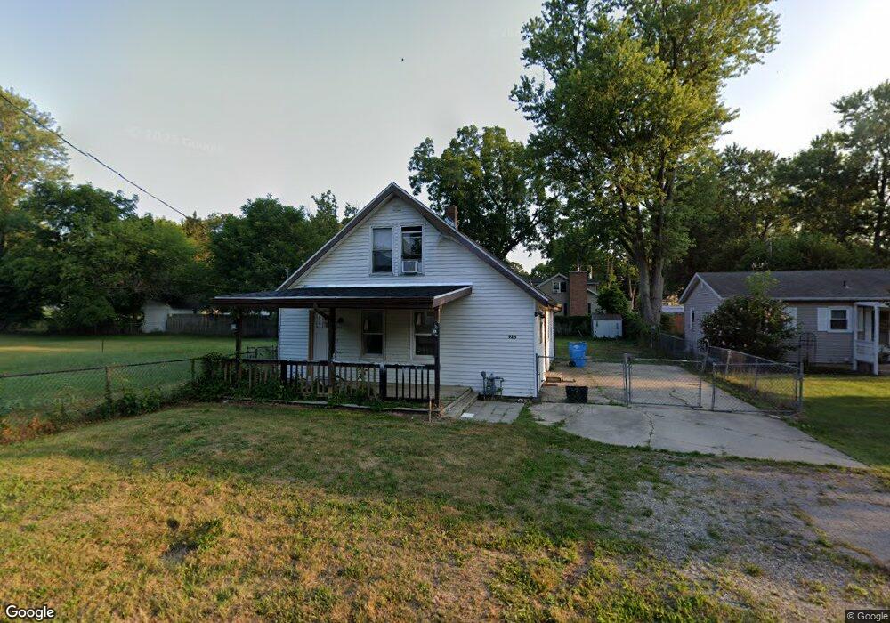
This home is located at 923 Birch St, Niles, MI 49120 and is currently estimated at $143,203, approximately $114 per square foot. 923 Birch St is a home located in Berrien County with nearby schools including Ballard Elementary School, Oak Manor Sixth Grade Center, and Ring Lardner Middle School.
Ownership History
Date
Name
Owned For
Owner Type
Purchase Details
Closed on
Nov 13, 2021
Sold by
Kurwa Michigan Llc
Bought by
Hughes Mark and Hughes Lindsay
Current Estimated Value
Home Financials for this Owner
Home Financials are based on the most recent Mortgage that was taken out on this home.
Original Mortgage
$72,500
Outstanding Balance
$66,571
Interest Rate
3.14%
Mortgage Type
Land Contract Argmt. Of Sale
Estimated Equity
$76,632
Purchase Details
Closed on
Oct 27, 2020
Sold by
Bittle Cherie A
Bought by
Berrien County Treasurer
Purchase Details
Closed on
Oct 19, 2020
Sold by
Berrien County Treasurer
Bought by
Kurwa Badrudin
Purchase Details
Closed on
Oct 14, 2020
Sold by
Berrien County
Bought by
Kurwa Badrudin
Purchase Details
Closed on
Oct 2, 2008
Sold by
Grishaber Ella L
Bought by
Hsbc Bank Usa National Association
Purchase Details
Closed on
Jun 9, 1980
Create a Home Valuation Report for This Property
The Home Valuation Report is an in-depth analysis detailing your home's value as well as a comparison with similar homes in the area
Home Values in the Area
Average Home Value in this Area
Purchase History
| Date | Buyer | Sale Price | Title Company |
|---|---|---|---|
| Hughes Mark | $72,500 | None Available | |
| Berrien County Treasurer | -- | Berrien County Treasurer | |
| Kurwa Badrudin | $40,250 | None Listed On Document | |
| Kurwa Badrudin | -- | None Available | |
| Hsbc Bank Usa National Association | $40,597 | None Available | |
| -- | $100 | -- |
Source: Public Records
Mortgage History
| Date | Status | Borrower | Loan Amount |
|---|---|---|---|
| Open | Hughes Mark | $72,500 |
Source: Public Records
Tax History Compared to Growth
Tax History
| Year | Tax Paid | Tax Assessment Tax Assessment Total Assessment is a certain percentage of the fair market value that is determined by local assessors to be the total taxable value of land and additions on the property. | Land | Improvement |
|---|---|---|---|---|
| 2025 | $2,010 | $53,500 | $0 | $0 |
| 2024 | $1,065 | $49,700 | $0 | $0 |
| 2023 | $1,021 | $45,300 | $0 | $0 |
| 2022 | $1,026 | $37,900 | $0 | $0 |
| 2021 | $1,765 | $31,400 | $3,900 | $27,500 |
| 2020 | $1,302 | $32,500 | $0 | $0 |
| 2019 | $1,283 | $25,500 | $1,800 | $23,700 |
| 2018 | $844 | $25,500 | $0 | $0 |
| 2017 | $1,223 | $21,600 | $0 | $0 |
| 2016 | $930 | $24,600 | $0 | $0 |
| 2015 | $994 | $26,500 | $0 | $0 |
| 2014 | $773 | $26,400 | $0 | $0 |
Source: Public Records
Map
Nearby Homes
- 537 Grant St
- 124 S State St
- V/L Wesaw Rd
- 413 S Street Joseph Ave
- 211 S Street Joseph Ave
- 1010 Tomahawk Ln
- 1639 Sioux Trail
- 211 S 4th St
- 319 S 5th St
- 712 Maple St
- 705 Oak St
- 300 Carefree Ct
- Integrity 1610 Plan at Carefree Villas
- Integrity 1605 Plan at Carefree Villas
- Integrity 1250 Plan at Carefree Villas
- Integrity 1530 Plan at Carefree Villas
- VL Huron St
- 314 N 6th St
- 340 Carefree Ct
- 709 Regent St