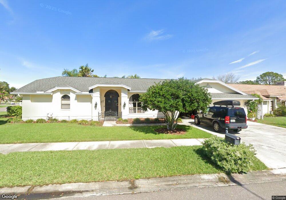
923 Kingscote Ct Safety Harbor, FL 34695
Estimated Value: $834,599 - $858,000
4
Beds
2
Baths
2,397
Sq Ft
$351/Sq Ft
Est. Value
About This Home
This home is located at 923 Kingscote Ct, Safety Harbor, FL 34695 and is currently estimated at $842,150, approximately $351 per square foot. 923 Kingscote Ct is a home located in Pinellas County with nearby schools including Safety Harbor Elementary School, Countryside High School, and Safety Harbor Middle School.
Ownership History
Date
Name
Owned For
Owner Type
Purchase Details
Closed on
Nov 14, 2016
Sold by
Veaks Elizabeth A
Bought by
Hare Dorothy R O and Hare Jameas S O
Current Estimated Value
Home Financials for this Owner
Home Financials are based on the most recent Mortgage that was taken out on this home.
Original Mortgage
$364,000
Outstanding Balance
$292,229
Interest Rate
3.42%
Mortgage Type
New Conventional
Estimated Equity
$549,921
Purchase Details
Closed on
Oct 16, 2006
Sold by
Kukulka Kenneth and Kukulka Barbara J
Bought by
Veakis Elizabeth A
Create a Home Valuation Report for This Property
The Home Valuation Report is an in-depth analysis detailing your home's value as well as a comparison with similar homes in the area
Home Values in the Area
Average Home Value in this Area
Purchase History
| Date | Buyer | Sale Price | Title Company |
|---|---|---|---|
| Hare Dorothy R O | $455,000 | None Available | |
| Veakis Elizabeth A | $487,000 | Republic Land & Title Inc |
Source: Public Records
Mortgage History
| Date | Status | Borrower | Loan Amount |
|---|---|---|---|
| Open | Hare Dorothy R O | $364,000 |
Source: Public Records
Tax History Compared to Growth
Tax History
| Year | Tax Paid | Tax Assessment Tax Assessment Total Assessment is a certain percentage of the fair market value that is determined by local assessors to be the total taxable value of land and additions on the property. | Land | Improvement |
|---|---|---|---|---|
| 2024 | $6,320 | $418,041 | -- | -- |
| 2023 | $6,320 | $405,865 | $0 | $0 |
| 2022 | $6,155 | $394,044 | $0 | $0 |
| 2021 | $6,250 | $382,567 | $0 | $0 |
| 2020 | $6,242 | $377,285 | $0 | $0 |
| 2019 | $6,143 | $368,803 | $0 | $0 |
| 2018 | $6,161 | $366,894 | $0 | $0 |
| 2017 | $6,118 | $359,348 | $0 | $0 |
| 2016 | $4,039 | $247,576 | $0 | $0 |
| 2015 | $4,124 | $245,855 | $0 | $0 |
| 2014 | $4,104 | $243,904 | $0 | $0 |
Source: Public Records
Map
Nearby Homes
- 1119 Huntington Ln
- 1005 Chatham Ct
- 910 Kingscote Ct
- 1111 Chatham Ct
- 1009 Wyndham Way
- 720 Earls Ct
- 3321 Meander Ln
- 1205 Hounds Run
- 2208 Hampstead Ct
- 605 Quail Keep Dr
- 647 Fairmont Ave Unit C
- 511 Haverhill Ln
- 2363 Flanders Way Unit C
- 1209 Roxbury Dr
- 2225 Windsong Ct
- 2368 Flanders Way Unit D
- 603 Baldwin Ave Unit B
- 615 Fairmont Ave Unit C
- 612 Fairmont Ave Unit D
- 511 Longfellow Ct Unit D
- 1202 Huntington Ln
- 921 Kingscote Ct
- 924 Kingscote Ct
- 922 Kingscote Ct
- 1201 Huntington Ln
- 1204 Huntington Ln
- 919 Kingscote Ct
- 901 Kingscote Ct
- 905 Kingscote Ct
- 1117 Huntington Ln
- 1205 Huntington Ln
- 1116 Huntington Ln
- 1115 Cheshire Ct
- 1206 Huntington Ln
- 913 Kingscote Ct
- 1003 Chatham Ct
- 1115 Huntington Ln
- 1001 Chatham Ct
- 1118 Cheshire Ct
- 1114 Huntington Ln