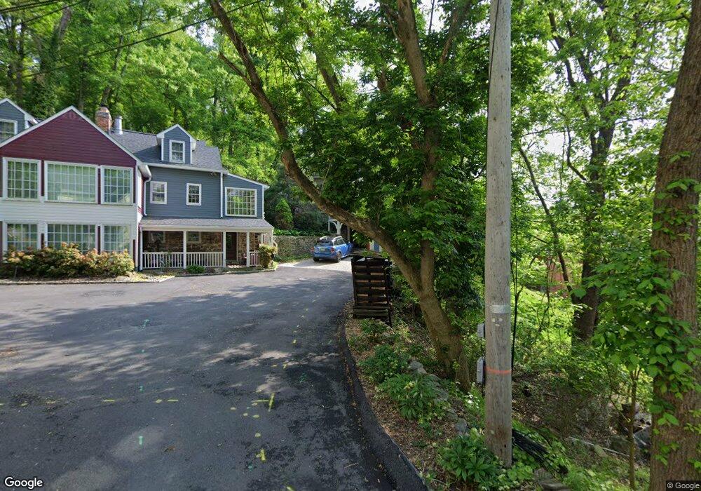
923 Logtown Rd Ellicott City, MD 21043
Estimated Value: $641,000 - $883,000
--
Bed
3
Baths
2,810
Sq Ft
$257/Sq Ft
Est. Value
About This Home
This home is located at 923 Logtown Rd, Ellicott City, MD 21043 and is currently estimated at $721,591, approximately $256 per square foot. 923 Logtown Rd is a home located in Baltimore County with nearby schools including Westchester Elementary School, Catonsville Middle School, and Catonsville High School.
Ownership History
Date
Name
Owned For
Owner Type
Purchase Details
Closed on
Nov 14, 2024
Sold by
Wilhide Stephen E and Wilhide Cheryl F
Bought by
Stephen And Cheryl Wilhide Revocable Trust and Wilhide
Current Estimated Value
Purchase Details
Closed on
Jun 28, 1988
Sold by
Wagandt Charles L
Bought by
Wilhide Stephen E and Wilhide Cheryl F
Create a Home Valuation Report for This Property
The Home Valuation Report is an in-depth analysis detailing your home's value as well as a comparison with similar homes in the area
Home Values in the Area
Average Home Value in this Area
Purchase History
| Date | Buyer | Sale Price | Title Company |
|---|---|---|---|
| Stephen And Cheryl Wilhide Revocable Trust | -- | None Listed On Document | |
| Stephen And Cheryl Wilhide Revocable Trust | -- | None Listed On Document | |
| Wilhide Stephen E | $186,000 | -- |
Source: Public Records
Tax History Compared to Growth
Tax History
| Year | Tax Paid | Tax Assessment Tax Assessment Total Assessment is a certain percentage of the fair market value that is determined by local assessors to be the total taxable value of land and additions on the property. | Land | Improvement |
|---|---|---|---|---|
| 2025 | $6,463 | $501,567 | -- | -- |
| 2024 | $6,463 | $477,900 | $179,500 | $298,400 |
| 2023 | $3,273 | $473,333 | $0 | $0 |
| 2022 | $6,407 | $468,767 | $0 | $0 |
| 2021 | $6,344 | $464,200 | $179,500 | $284,700 |
| 2020 | $6,344 | $464,200 | $179,500 | $284,700 |
| 2019 | $6,389 | $464,200 | $179,500 | $284,700 |
| 2018 | $6,261 | $582,100 | $142,100 | $440,000 |
| 2017 | $5,981 | $569,267 | $0 | $0 |
| 2016 | $4,933 | $556,433 | $0 | $0 |
| 2015 | $4,933 | $543,600 | $0 | $0 |
| 2014 | $4,933 | $543,600 | $0 | $0 |
Source: Public Records
Map
Nearby Homes
- 9794 Blue Ivy Way
- 3700 College Ave Unit 301
- 3598 Fels Ln
- 20 Bryans Mill Way
- 3646 Fels Ln
- 0 Alvin Ave
- 8369 Governor Grayson Way
- 8412 Merryman St
- 8483 Frederick Rd
- 8100 Hickory Dr Unit H
- 105 Oella Ave
- 2310 Rockwell Ave
- 406 Chalfonte Dr
- 2111 Stonewall Rd
- 8643 Ridge Rd
- 510 Bathurst Rd
- 3453 Orange Grove Ct
- 4 Rumford Dr Unit 203
- 2203 Rockwell Ave
- 2992 Normandy Dr
- 921 Oella Ave
- 921 Logtown Rd
- 939 Oella Ave
- 937 Oella Ave
- 941 Oella Ave
- 935 Oella Ave
- 943 Oella Ave
- 933 Oella Ave
- 945 Oella Ave
- 931 Oella Ave
- 947 Oella Ave
- 929 Oella Ave
- 917 Oella Ave
- 917 Logtown Rd
- 919 Logtown Rd
- 963 Oella Ave
- 797 Charles James Cir
- 799 Charles James Cir
- 1001 Lillies Ln
- 1003 Lillies Ln