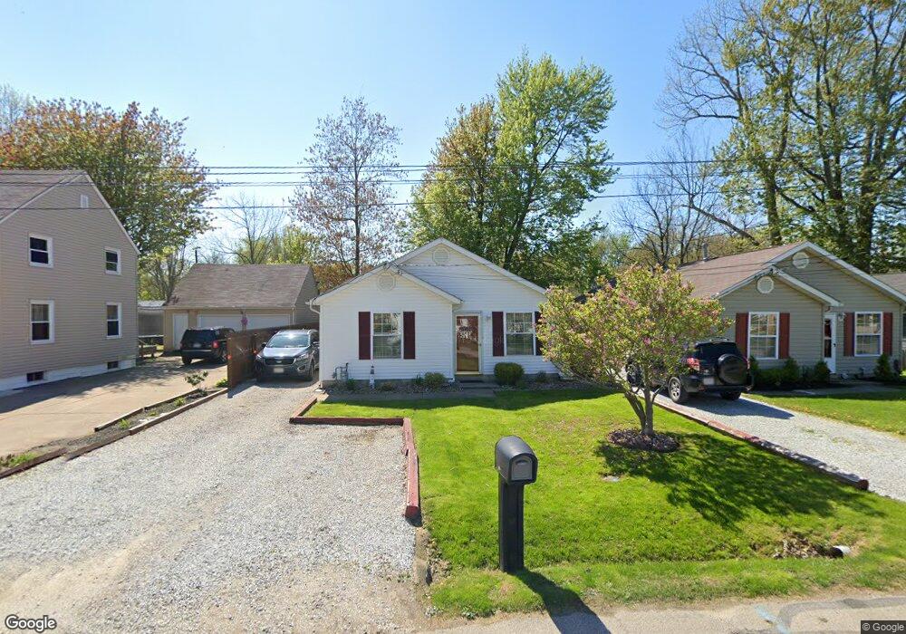
923 Pontiac Ave Painesville, OH 44077
Estimated Value: $156,000 - $172,000
3
Beds
2
Baths
1,176
Sq Ft
$140/Sq Ft
Est. Value
About This Home
This home is located at 923 Pontiac Ave, Painesville, OH 44077 and is currently estimated at $164,887, approximately $140 per square foot. 923 Pontiac Ave is a home located in Lake County with nearby schools including Henry F. Lamuth Middle School, Riverside Junior/Senior High School, and Summit Academy Community School - Painesville.
Ownership History
Date
Name
Owned For
Owner Type
Purchase Details
Closed on
Oct 9, 2012
Sold by
Hall James A
Bought by
Beseda Mary M
Current Estimated Value
Purchase Details
Closed on
Sep 21, 1999
Sold by
L & L Homes Inc
Bought by
Hall James A and Beseda Mary M
Home Financials for this Owner
Home Financials are based on the most recent Mortgage that was taken out on this home.
Original Mortgage
$82,700
Interest Rate
7.9%
Mortgage Type
FHA
Create a Home Valuation Report for This Property
The Home Valuation Report is an in-depth analysis detailing your home's value as well as a comparison with similar homes in the area
Home Values in the Area
Average Home Value in this Area
Purchase History
| Date | Buyer | Sale Price | Title Company |
|---|---|---|---|
| Beseda Mary M | -- | None Available | |
| Hall James A | $82,800 | House Of Title Agency Inc, T |
Source: Public Records
Mortgage History
| Date | Status | Borrower | Loan Amount |
|---|---|---|---|
| Closed | Hall James A | $82,700 |
Source: Public Records
Tax History Compared to Growth
Tax History
| Year | Tax Paid | Tax Assessment Tax Assessment Total Assessment is a certain percentage of the fair market value that is determined by local assessors to be the total taxable value of land and additions on the property. | Land | Improvement |
|---|---|---|---|---|
| 2024 | -- | $57,280 | $5,540 | $51,740 |
| 2023 | $4,095 | $37,580 | $4,450 | $33,130 |
| 2022 | $2,920 | $37,580 | $4,450 | $33,130 |
| 2021 | $2,712 | $37,580 | $4,450 | $33,130 |
| 2020 | $2,192 | $32,670 | $3,860 | $28,810 |
| 2019 | $2,494 | $32,670 | $3,860 | $28,810 |
| 2018 | $2,278 | $33,560 | $3,090 | $30,470 |
| 2017 | $2,341 | $33,560 | $3,090 | $30,470 |
| 2016 | $2,416 | $33,560 | $3,090 | $30,470 |
| 2015 | $1,921 | $33,560 | $3,090 | $30,470 |
| 2014 | $1,952 | $33,560 | $3,090 | $30,470 |
| 2013 | $1,908 | $33,560 | $3,090 | $30,470 |
Source: Public Records
Map
Nearby Homes
- 0 Fremont Ave Unit 5152717
- 125 Sycamore Dr
- 856 Beech Ave
- 0 Bellevue Ave Unit 5152736
- 988 Oakwood Blvd
- 961 Beachfront Dr
- 124 Kenilworth Ave
- 960 Robinhood Ave
- 1006 Robinhood Ave
- 1679 Duffton Ln
- 1719 Duffton Ln
- 547 Greenside Dr
- 499 Sand Trap Cir
- 1791 Muirfield Ln
- 1806 Muirfield Ln
- 751 Bacon Rd
- 389 Sand Trap Cir
- 1865 Marsh Ln Unit 1865
- 1978 Marsh Ln Unit 1978
- 720 N Creek Dr
- 927 Pontiac Ave
- 919 Pontiac Ave
- 931 Pontiac Ave
- 924 Arden Ave
- 938 Arden Ave
- 920 Arden Ave
- 911 Pontiac Ave
- 936 Arden Ave
- 928 Pontiac Ave
- 916 Arden Ave
- 936 Pontiac Ave
- 916 Pontiac Ave
- 77 Sycamore Dr
- 81 Sycamore Dr
- 921 Arden Ave
- 80 Sycamore Dr
- 968 Pontiac Ave
- 901 Pontiac Ave
- 933 Fremont Ave
- 913 Arden Ave