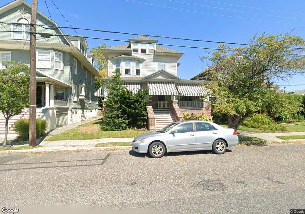
923 Stockton Ave Cape May, NJ 08204
Estimated Value: $1,251,000 - $2,610,000
--
Bed
--
Bath
2,734
Sq Ft
$707/Sq Ft
Est. Value
About This Home
This home is located at 923 Stockton Ave, Cape May, NJ 08204 and is currently estimated at $1,931,581, approximately $706 per square foot. 923 Stockton Ave is a home located in Cape May County with nearby schools including Cape May City Elementary School, Richard M. Teitelman School, and Lower Cape May Regional High School.
Ownership History
Date
Name
Owned For
Owner Type
Purchase Details
Closed on
Nov 4, 2021
Sold by
John A Clark Lt
Bought by
Mcduell Carol C and Mcduell John E
Current Estimated Value
Purchase Details
Closed on
Jul 20, 2007
Sold by
The Eileen D Clark Living Trust and Clark John A
Bought by
The John A Clark Living Trust and The Eileen D Clark Credit Shelter Trust
Purchase Details
Closed on
Nov 22, 2004
Sold by
Clark Eileen D
Bought by
Clark Eileen D
Create a Home Valuation Report for This Property
The Home Valuation Report is an in-depth analysis detailing your home's value as well as a comparison with similar homes in the area
Home Values in the Area
Average Home Value in this Area
Purchase History
| Date | Buyer | Sale Price | Title Company |
|---|---|---|---|
| Mcduell Carol C | $900,000 | None Available | |
| Mcduell Carol C | $900,000 | None Listed On Document | |
| The John A Clark Living Trust | -- | None Available | |
| Clark Eileen D | -- | -- |
Source: Public Records
Tax History Compared to Growth
Tax History
| Year | Tax Paid | Tax Assessment Tax Assessment Total Assessment is a certain percentage of the fair market value that is determined by local assessors to be the total taxable value of land and additions on the property. | Land | Improvement |
|---|---|---|---|---|
| 2025 | $11,432 | $1,105,200 | $793,800 | $311,400 |
| 2024 | $11,432 | $1,105,200 | $793,800 | $311,400 |
| 2023 | $11,620 | $1,105,200 | $793,800 | $311,400 |
| 2022 | $11,156 | $1,105,200 | $793,800 | $311,400 |
| 2021 | $7,665 | $1,105,200 | $793,800 | $311,400 |
| 2020 | $10,470 | $1,105,200 | $793,800 | $311,400 |
| 2019 | $10,658 | $1,105,200 | $793,800 | $311,400 |
| 2018 | $10,039 | $1,105,200 | $793,800 | $311,400 |
| 2017 | $9,520 | $1,105,200 | $793,800 | $311,400 |
| 2016 | $8,945 | $1,105,200 | $793,800 | $311,400 |
| 2015 | $9,310 | $1,105,200 | $793,800 | $311,400 |
| 2014 | $9,310 | $1,105,200 | $793,800 | $311,400 |
Source: Public Records
Map
Nearby Homes
- 918 Stockton Ave
- 610 Beach Ave
- 819 Beach Ave Unit B1
- 1025 New York Ave
- 106 Howard St Unit A
- 106 A Howard St
- 614 Jefferson St
- 519 Franklin St
- 626 Hughes St
- 645 Hughes St
- 627 Hughes St
- 24 Ocean St
- 202 Ocean St
- 210 Ocean St Unit 1
- 1047 Virginia Ave
- 933 Washington St
- 523 Lafayette St Unit 2
- 1015 Washington St
- 936 Lafayette St Unit 5
- 1132 Illinois Ave
- 925 Stockton Ave
- 921 Stockton Ave
- 112 Queen St
- 919 Stockton Ave
- 20 Queen St
- 926 Kearney Ave
- 917 Stockton Ave
- 915 Stockton Ave
- 101 Queen St
- 1003 Stockton Ave
- 916 Stockton Ave
- 16 Queen St
- 924 Kearney Ave
- 105 Queen St
- 911 Stockton Ave
- 21 Queen St
- 914 Stockton Ave
- 931 Kearney Ave
- 1005 Stockton Ave
- 922 Kearney Ave