Estimated Value: $261,343 - $327,000
3
Beds
2
Baths
1,560
Sq Ft
$189/Sq Ft
Est. Value
About This Home
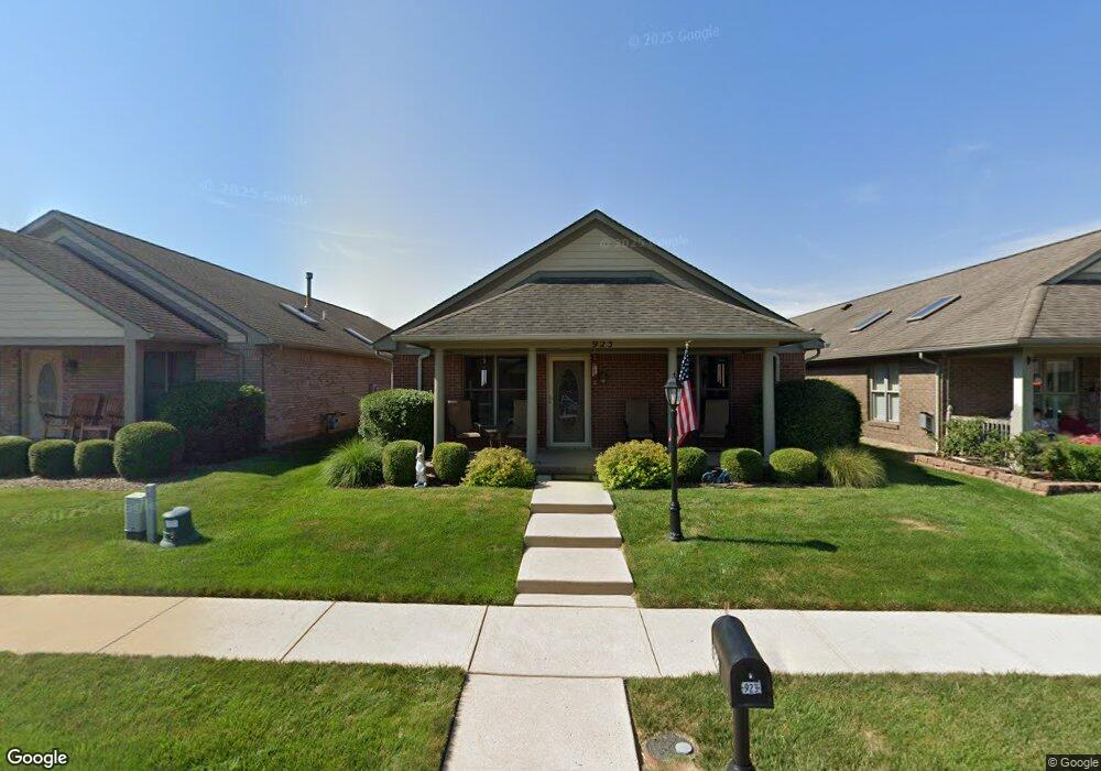
This home is located at 923 Wright Ave, Xenia, OH 45385 and is currently estimated at $294,836, approximately $188 per square foot. 923 Wright Ave is a home located in Greene County with nearby schools including Xenia High School, Summit Academy Community School for Alternative Learners - Xenia, and Legacy Christian Academy.
Ownership History
Date
Name
Owned For
Owner Type
Purchase Details
Closed on
Jul 31, 2002
Sold by
Be Am Co Inc
Bought by
Williams Harold M and Williams Judith A
Current Estimated Value
Home Financials for this Owner
Home Financials are based on the most recent Mortgage that was taken out on this home.
Original Mortgage
$98,900
Outstanding Balance
$30,931
Interest Rate
3.62%
Estimated Equity
$263,905
Purchase Details
Closed on
Oct 30, 1997
Sold by
P F D Dev Pll
Bought by
Be/Am/Co Inc
Create a Home Valuation Report for This Property
The Home Valuation Report is an in-depth analysis detailing your home's value as well as a comparison with similar homes in the area
Home Values in the Area
Average Home Value in this Area
Purchase History
| Date | Buyer | Sale Price | Title Company |
|---|---|---|---|
| Williams Harold M | $144,400 | -- | |
| Be/Am/Co Inc | $292,500 | -- |
Source: Public Records
Mortgage History
| Date | Status | Borrower | Loan Amount |
|---|---|---|---|
| Open | Williams Harold M | $98,900 |
Source: Public Records
Tax History
| Year | Tax Paid | Tax Assessment Tax Assessment Total Assessment is a certain percentage of the fair market value that is determined by local assessors to be the total taxable value of land and additions on the property. | Land | Improvement |
|---|---|---|---|---|
| 2025 | $3,068 | $72,250 | $10,500 | $61,750 |
| 2024 | $3,068 | $72,250 | $10,500 | $61,750 |
| 2023 | $3,012 | $72,250 | $10,500 | $61,750 |
| 2022 | $2,683 | $54,870 | $7,000 | $47,870 |
| 2021 | $2,720 | $54,870 | $7,000 | $47,870 |
| 2020 | $2,603 | $54,870 | $7,000 | $47,870 |
| 2019 | $2,376 | $47,140 | $6,430 | $40,710 |
| 2018 | $2,385 | $47,140 | $6,430 | $40,710 |
| 2017 | $2,247 | $47,140 | $6,430 | $40,710 |
| 2016 | $2,248 | $43,620 | $6,430 | $37,190 |
| 2015 | $2,254 | $43,620 | $6,430 | $37,190 |
| 2014 | $2,156 | $43,620 | $6,430 | $37,190 |
Source: Public Records
Map
Nearby Homes
- 2102 High Wheel Dr
- 920 Wright Cycle Blvd
- 926 Wright Cycle Blvd
- 1978 Lakeview Dr
- 2276 Tandem Dr
- 2632 Ketki Ct
- 1955 Roxbury Dr
- 0 Lower Bellbrook Rd
- 2516 Jenny Marie Dr
- 0 Berkshire Dr Unit 949217
- 2247 Dundee Dr
- 1816 Atkinson Dr
- 2216 Minnesota Dr
- 1321 Massachusetts Dr
- 1772 Pueblo Dr
- 1001 Glen Kegley Dr
- 1068 Hedges Rd
- 1715 Sioux Dr
- 1182 Bellbrook Ave
- 1861 Nebraska Dr
- 927 Wright Ave
- 919 Wright Ave
- 931 Wright Ave
- 915 Wright Ave
- 911 Wright Ave
- 935 Wright Ave
- 922 Cannondale Ave
- 926 Cannondale Ave
- 918 Cannondale Ave
- 939 Wright Ave
- 907 Wright Ave
- 930 Cannondale Ave
- 914 Cannondale Ave
- 922 Wright Ave
- 918 Wright Ave
- 926 Wright Ave
- 934 Cannondale Ave
- 910 Cannondale Ave
- 914 Wright Ave
- 930 Wright Ave
Your Personal Tour Guide
Ask me questions while you tour the home.