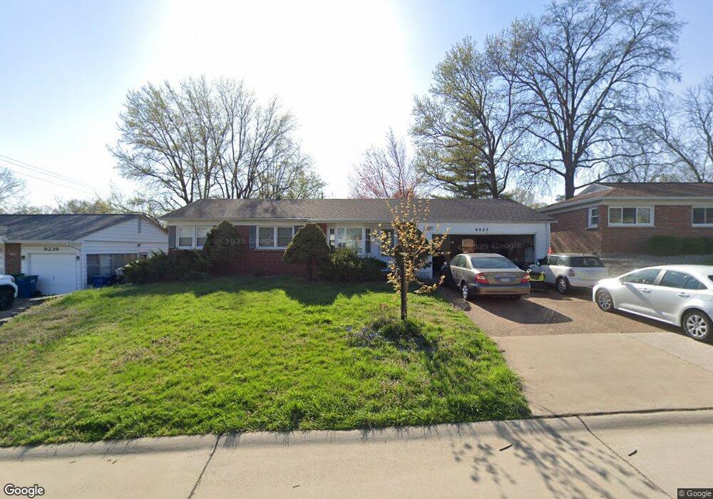
9235 Papoose Dr Saint Louis, MO 63123
Lemay NeighborhoodEstimated Value: $235,000 - $266,000
3
Beds
2
Baths
1,270
Sq Ft
$198/Sq Ft
Est. Value
About This Home
This home is located at 9235 Papoose Dr, Saint Louis, MO 63123 and is currently estimated at $251,578, approximately $198 per square foot. 9235 Papoose Dr is a home located in St. Louis County with nearby schools including Bayless Elementary School, Bayless Junior High School, and Bayless Senior High School.
Ownership History
Date
Name
Owned For
Owner Type
Purchase Details
Closed on
Jul 8, 2025
Sold by
9235 Papoose Drive Llc
Bought by
Pfitzer Nathan H and Pfitzer Shannon K
Current Estimated Value
Home Financials for this Owner
Home Financials are based on the most recent Mortgage that was taken out on this home.
Original Mortgage
$178,000
Outstanding Balance
$177,699
Interest Rate
6.85%
Mortgage Type
New Conventional
Estimated Equity
$73,879
Purchase Details
Closed on
Dec 27, 2019
Sold by
Johnston Patrick H and Tinker Kathryn Edith
Bought by
9235 Papoose Drive Llc
Purchase Details
Closed on
Aug 25, 1998
Sold by
Gallego Billie J
Bought by
Johnston Patrick H and Johnston Sandra K
Home Financials for this Owner
Home Financials are based on the most recent Mortgage that was taken out on this home.
Original Mortgage
$94,400
Interest Rate
6.94%
Create a Home Valuation Report for This Property
The Home Valuation Report is an in-depth analysis detailing your home's value as well as a comparison with similar homes in the area
Home Values in the Area
Average Home Value in this Area
Purchase History
| Date | Buyer | Sale Price | Title Company |
|---|---|---|---|
| Pfitzer Nathan H | -- | None Listed On Document | |
| 9235 Papoose Drive Llc | $128,000 | Freedom Title Llc St Louis | |
| Johnston Patrick H | -- | -- |
Source: Public Records
Mortgage History
| Date | Status | Borrower | Loan Amount |
|---|---|---|---|
| Open | Pfitzer Nathan H | $178,000 | |
| Previous Owner | Johnston Patrick H | $94,400 |
Source: Public Records
Tax History Compared to Growth
Tax History
| Year | Tax Paid | Tax Assessment Tax Assessment Total Assessment is a certain percentage of the fair market value that is determined by local assessors to be the total taxable value of land and additions on the property. | Land | Improvement |
|---|---|---|---|---|
| 2025 | $2,545 | $41,970 | $13,470 | $28,500 |
| 2024 | $2,545 | $34,960 | $7,260 | $27,700 |
| 2023 | $2,545 | $34,960 | $7,260 | $27,700 |
| 2022 | $2,786 | $32,920 | $8,280 | $24,640 |
| 2021 | $2,521 | $32,920 | $8,280 | $24,640 |
| 2020 | $2,534 | $30,650 | $8,890 | $21,760 |
| 2019 | $2,527 | $30,650 | $8,890 | $21,760 |
| 2018 | $2,434 | $26,170 | $6,920 | $19,250 |
| 2017 | $2,286 | $26,170 | $6,920 | $19,250 |
| 2016 | $2,083 | $23,430 | $4,640 | $18,790 |
| 2015 | $2,092 | $23,430 | $4,640 | $18,790 |
| 2014 | $2,303 | $25,750 | $5,040 | $20,710 |
Source: Public Records
Map
Nearby Homes
- 816 Forman Rd
- 9430 Dana Ave
- 9038 Kickapoo Dr
- 9544 Dana Ave
- 4415 Cayuga Dr
- 9121 Niger Dr
- 8709 Holbrook Dr
- 9108 Tiber Ct
- 9140 Arvin Place
- 8911 Kammerer Ave
- 9117 Tiber Ct
- 4500 Spring Dr
- 9606 Dana Ave
- 4409 Fatima Dr
- 8706 Fatima Dr
- 8628 Hillery Dr
- 8550 Pilot Ave
- 9211 Niles Place
- 5515 Maxwell Ave
- 4248 Kay Ln Unit 9
- 9231 Papoose Dr
- 9239 Papoose Dr
- 9238 Mackinaw Dr
- 9242 Mackinaw Dr
- 9234 Mackinaw Dr
- 4809 Cayuga Dr
- 9245 Papoose Dr
- 4813 Cayuga Dr
- 9240 Papoose Dr
- 9232 Papoose Dr
- 9223 Papoose Dr
- 9230 Mackinaw Dr
- 9244 Papoose Dr
- 9246 Mackinaw Dr
- 9248 Papoose Dr
- 9226 Mackinaw Dr
- 9219 Papoose Dr
- 4713 Warrior Dr
- 9252 Papoose Dr
- 9301 Warrior Dr