Estimated Value: $505,000 - $647,281
5
Beds
4
Baths
3,211
Sq Ft
$186/Sq Ft
Est. Value
About This Home
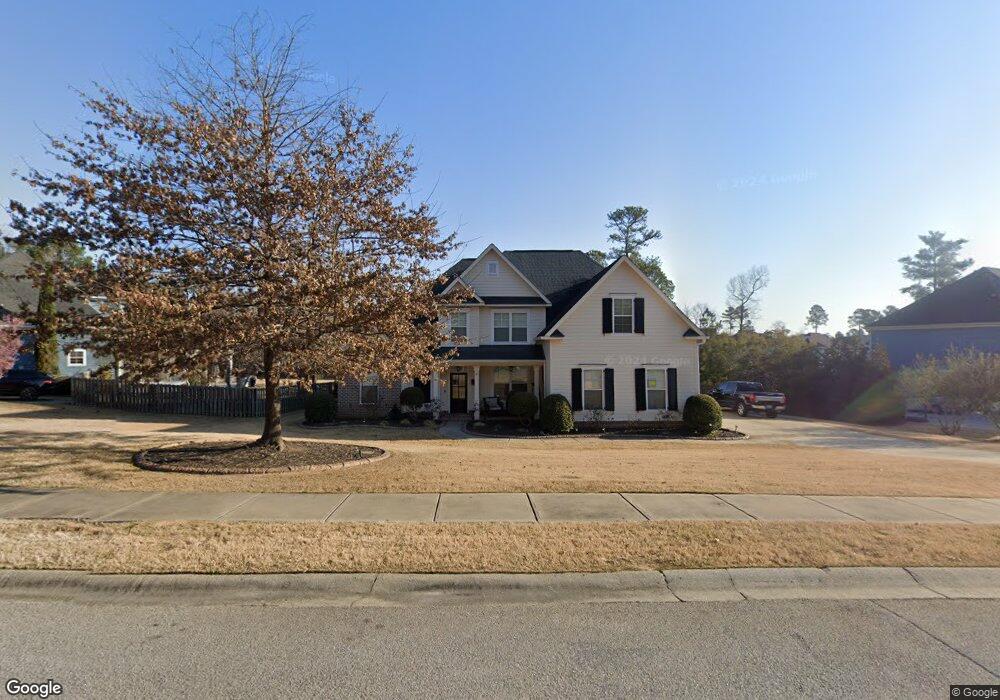
This home is located at 924 Bartram Ridge, Evans, GA 30809 and is currently estimated at $598,820, approximately $186 per square foot. 924 Bartram Ridge is a home located in Columbia County with nearby schools including Lewiston Elementary School, Columbia Middle School, and Grovetown High School.
Ownership History
Date
Name
Owned For
Owner Type
Purchase Details
Closed on
Oct 21, 2010
Sold by
Rt Smith Const Llc
Bought by
Windom William R
Current Estimated Value
Home Financials for this Owner
Home Financials are based on the most recent Mortgage that was taken out on this home.
Original Mortgage
$274,500
Outstanding Balance
$181,417
Interest Rate
4.38%
Mortgage Type
New Conventional
Estimated Equity
$417,403
Purchase Details
Closed on
Apr 30, 2010
Sold by
Euchee Creek Invst Inc
Bought by
Rt Smith Const Llc
Home Financials for this Owner
Home Financials are based on the most recent Mortgage that was taken out on this home.
Original Mortgage
$260,000
Interest Rate
5.06%
Mortgage Type
New Conventional
Create a Home Valuation Report for This Property
The Home Valuation Report is an in-depth analysis detailing your home's value as well as a comparison with similar homes in the area
Home Values in the Area
Average Home Value in this Area
Purchase History
| Date | Buyer | Sale Price | Title Company |
|---|---|---|---|
| Windom William R | $305,000 | -- | |
| Rt Smith Const Llc | $49,500 | -- |
Source: Public Records
Mortgage History
| Date | Status | Borrower | Loan Amount |
|---|---|---|---|
| Open | Windom William R | $274,500 | |
| Previous Owner | Rt Smith Const Llc | $260,000 |
Source: Public Records
Tax History
| Year | Tax Paid | Tax Assessment Tax Assessment Total Assessment is a certain percentage of the fair market value that is determined by local assessors to be the total taxable value of land and additions on the property. | Land | Improvement |
|---|---|---|---|---|
| 2025 | $5,699 | $236,571 | $51,204 | $185,367 |
| 2024 | $5,623 | $222,764 | $46,004 | $176,760 |
| 2023 | $5,623 | $209,344 | $46,004 | $163,340 |
| 2022 | $4,315 | $163,844 | $35,104 | $128,740 |
| 2021 | $4,216 | $152,963 | $32,404 | $120,559 |
| 2020 | $4,086 | $145,098 | $31,904 | $113,194 |
| 2019 | $4,093 | $145,360 | $30,204 | $115,156 |
| 2018 | $4,001 | $141,579 | $30,604 | $110,975 |
| 2017 | $3,842 | $135,391 | $28,604 | $106,787 |
| 2016 | $3,563 | $130,029 | $27,780 | $102,249 |
| 2015 | $3,529 | $128,549 | $26,780 | $101,769 |
| 2014 | $3,350 | $120,397 | $26,780 | $93,617 |
Source: Public Records
Map
Nearby Homes
- 2223 Fothergill Dr
- 818 Long Cane Ridge
- 5639 Sunbury Loop
- 971 Bartram Ridge
- 5629 Sunbury Loop
- 603 Altamaha Cir
- 4320 Sabal Dr
- 4328 Sabal Dr
- 2132 Fothergill Dr
- 1037 Bartram Ridge
- 5355 Magnolia Dr
- 2218 Fossil Trace Ln
- 336 Streamsong Rd
- 344 Streamsong Rd
- 347 Streamsong Rd
- 123 Ellerston Dr
- 349 Streamsong Rd
- 351 Streamsong Rd
- 4632 Southwind Rd
- 4703 Southwind Rd
- 926 Bartram Ridge
- 922 Bartram Ridge
- 2102 Fothergill Dr
- 927 Bartram Ridge
- 920 Bartram Ridge
- 925 Bartram Ridge
- 1001 Bartram Ridge
- 2231 Fothergill Dr
- 2229 Fothergill Dr
- 1003 Kalmia Cir
- 2104 Fothergill Dr
- 930 Bartram Ridge
- 1002 Kalmia Cir
- 1001 Kalmia Cir
- 2103 Fothergill Dr
- 2227 Fothergill Dr
- 1004 Kalmia Cir
- 919 Bartram Ridge
- 2105 Fothergill Dr
- 1006 Kalmia Cir
Your Personal Tour Guide
Ask me questions while you tour the home.