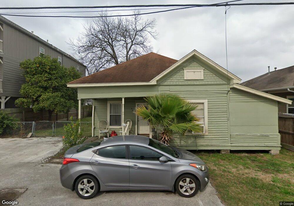
924 Dunbar St Houston, TX 77009
Greater Heights NeighborhoodEstimated Value: $430,380 - $506,000
2
Beds
1
Bath
836
Sq Ft
$557/Sq Ft
Est. Value
About This Home
This home is located at 924 Dunbar St, Houston, TX 77009 and is currently estimated at $465,345, approximately $556 per square foot. 924 Dunbar St is a home located in Harris County with nearby schools including Field Elementary School, Hogg Middle, and Heights High School.
Ownership History
Date
Name
Owned For
Owner Type
Purchase Details
Closed on
Feb 1, 1995
Sold by
Epperson Horace A and Epperson Joann
Bought by
Flores Encarnacion and Flores Bernabe
Current Estimated Value
Home Financials for this Owner
Home Financials are based on the most recent Mortgage that was taken out on this home.
Original Mortgage
$24,700
Interest Rate
10%
Create a Home Valuation Report for This Property
The Home Valuation Report is an in-depth analysis detailing your home's value as well as a comparison with similar homes in the area
Home Values in the Area
Average Home Value in this Area
Purchase History
| Date | Buyer | Sale Price | Title Company |
|---|---|---|---|
| Flores Encarnacion | $26,000 | -- |
Source: Public Records
Mortgage History
| Date | Status | Borrower | Loan Amount |
|---|---|---|---|
| Closed | Flores Encarnacion | $24,700 |
Source: Public Records
Tax History Compared to Growth
Tax History
| Year | Tax Paid | Tax Assessment Tax Assessment Total Assessment is a certain percentage of the fair market value that is determined by local assessors to be the total taxable value of land and additions on the property. | Land | Improvement |
|---|---|---|---|---|
| 2025 | $537 | $457,297 | $430,050 | $27,247 |
| 2024 | $537 | $474,130 | $453,670 | $20,460 |
| 2023 | $430 | $474,130 | $453,670 | $20,460 |
| 2022 | $7,346 | $406,743 | $388,860 | $17,883 |
| 2021 | $7,068 | $329,626 | $311,088 | $18,538 |
| 2020 | $6,676 | $329,626 | $311,088 | $18,538 |
| 2019 | $6,342 | $328,079 | $311,088 | $16,991 |
| 2018 | $944 | $250,501 | $226,835 | $23,666 |
| 2017 | $5,238 | $250,501 | $226,835 | $23,666 |
| 2016 | $4,762 | $225,836 | $200,918 | $24,918 |
| 2015 | $1,041 | $225,836 | $200,918 | $24,918 |
| 2014 | $1,041 | $155,629 | $132,032 | $23,597 |
Source: Public Records
Map
Nearby Homes
- 1005 Kern St Unit C
- 1005 Kern St Unit B
- 905 Kern St
- 1737 Airline Dr
- 931 Louise St
- 1340 Idylwild St
- 1719 Redwing Pines Dr
- 1106 Robbie St
- 738 Redwing Place Dr
- 1124 Dunbar St
- 1102 Winston St
- 1707 Redwing Cove Dr
- 1611 Airline Dr
- 1805 Emir St Unit G
- 1805 Emir St Unit D
- 1805 Emir St Unit L
- 1805 Emir St Unit E
- 1021 Nadine St
- 1131 Louise St
- 1122 Louise St
- 928 Dunbar St Unit B
- 920 Dunbar St
- 930 Dunbar St
- 917 Kern St
- 921 Kern St
- 913 Kern St
- 932 Dunbar St
- 929 Kern St
- 911 Kern St
- 911 Kern St Unit B
- 1733 Airline Dr
- 1733 Airline Dr Unit A
- 1733 Airline Dr Unit B
- 907 Kern St
- 907 Kern St Unit A
- 907 Kern St Unit B
- 5302 Michaux St
- 5304 Michaux St
- 1729 Airline Dr
- 939 Kern St