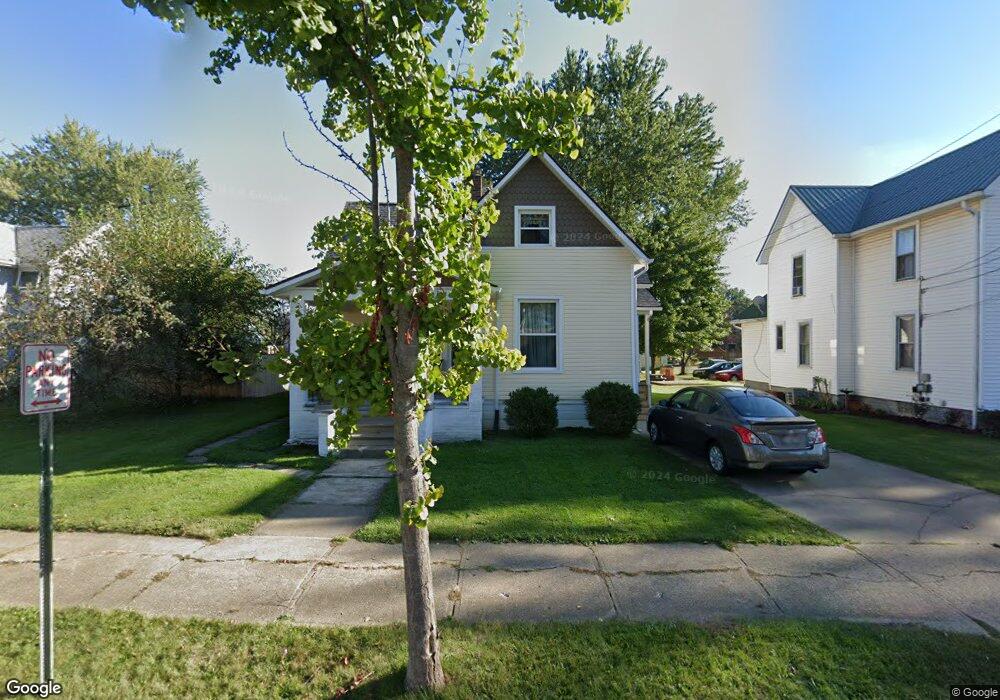
924 E Main St Louisville, OH 44641
Estimated Value: $137,261 - $195,000
3
Beds
1
Bath
1,561
Sq Ft
$113/Sq Ft
Est. Value
About This Home
This home is located at 924 E Main St, Louisville, OH 44641 and is currently estimated at $176,065, approximately $112 per square foot. 924 E Main St is a home located in Stark County with nearby schools including Louisville High School and St. Thomas Aquinas High School & Middle School.
Ownership History
Date
Name
Owned For
Owner Type
Purchase Details
Closed on
Oct 10, 2024
Sold by
Cramer Family Revocable Living Trust and Cramer Charles F
Bought by
Cramer Family Irrevocable Trust and Walters
Current Estimated Value
Purchase Details
Closed on
Nov 3, 2004
Sold by
Cramer Charles F and Cramer Barbara D
Bought by
Cramer Charles F and Cramer Barbara D
Purchase Details
Closed on
Aug 2, 1996
Sold by
Carroll Margaret
Bought by
Cramer Charles F
Purchase Details
Closed on
Oct 6, 1988
Create a Home Valuation Report for This Property
The Home Valuation Report is an in-depth analysis detailing your home's value as well as a comparison with similar homes in the area
Home Values in the Area
Average Home Value in this Area
Purchase History
| Date | Buyer | Sale Price | Title Company |
|---|---|---|---|
| Cramer Family Irrevocable Trust | -- | None Listed On Document | |
| Cramer Charles F | -- | -- | |
| Cramer Charles F | $49,900 | -- | |
| -- | $30,000 | -- |
Source: Public Records
Tax History
| Year | Tax Paid | Tax Assessment Tax Assessment Total Assessment is a certain percentage of the fair market value that is determined by local assessors to be the total taxable value of land and additions on the property. | Land | Improvement |
|---|---|---|---|---|
| 2025 | -- | $20,590 | $12,220 | $8,370 |
| 2024 | -- | $20,590 | $12,220 | $8,370 |
| 2023 | $1,544 | $23,460 | $9,630 | $13,830 |
| 2022 | $1,038 | $23,460 | $9,630 | $13,830 |
| 2021 | $1,041 | $23,460 | $9,630 | $13,830 |
| 2020 | $875 | $21,320 | $8,680 | $12,640 |
| 2019 | $899 | $21,950 | $8,680 | $13,270 |
Source: Public Records
Map
Nearby Homes
- 1010 Washington Ave
- 230 Superior St
- 319 Superior St
- 408 E Gorgas St
- 0 Michigan Blvd
- 313 Ickes Ct
- 1431 High St
- 304 South St
- 901 N Marion Ave
- 1830 Airpark Dr
- 435 Honeycrisp Dr NE
- 280 Kennedy St
- 161 Beau Chemin Ave Unit 6B
- 1709 Edmar St
- 1402 S Chapel St
- 316 E Reno Dr
- 514 Reno Dr
- 907 Park Village Dr
- 704 Reno Dr
- 2120 Edmar St
- 918 E Main St
- 930 E Main St
- 1000 E Main St
- 910 E Main St
- 922 Schaffer Ct
- 920 Schaffer Ct
- 1006 E Main St
- 927 E Gorgas St
- 110 Mckinley Ave
- 911 Schaffer Ct
- 935 E Gorgas St
- 116 S Silver St
- 1012 E Main St
- 902 E Main St
- 1007 E Gorgas St
- 921 E Gorgas St
- 206 S Silver St
- 206 S Silver St
- 1011 E Gorgas St
- 1016 E Main St
Your Personal Tour Guide
Ask me questions while you tour the home.