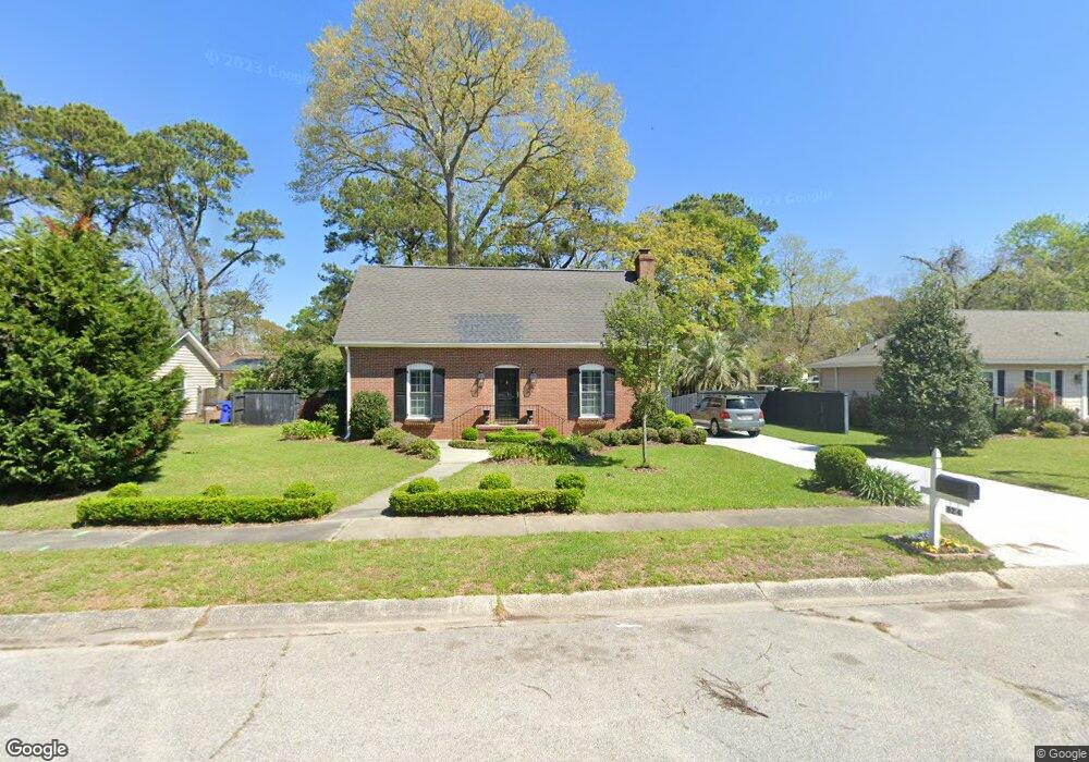
924 Ravenswood Dr Charleston, SC 29412
James Island NeighborhoodEstimated Value: $613,290 - $696,000
3
Beds
3
Baths
1,700
Sq Ft
$387/Sq Ft
Est. Value
About This Home
This home is located at 924 Ravenswood Dr, Charleston, SC 29412 and is currently estimated at $658,323, approximately $387 per square foot. 924 Ravenswood Dr is a home located in Charleston County with nearby schools including Stiles Point Elementary School, Camp Road Middle, and James Island Charter High School.
Ownership History
Date
Name
Owned For
Owner Type
Purchase Details
Closed on
Jun 10, 2013
Sold by
Rossi Julie M and Rossi Andrew P
Bought by
Rossi Mary and Rossi Angelo
Current Estimated Value
Purchase Details
Closed on
Aug 30, 2010
Sold by
Rossi Mary and Rossi Angelo
Bought by
Rossi Julia M and Rossi Andrew P
Purchase Details
Closed on
Jun 2, 2003
Sold by
Tarleton L Huntley and Tarleton Brittany M
Bought by
Rossi Mary and Rossi Angelo
Purchase Details
Closed on
Jun 24, 2002
Sold by
Ryan John F and Mcmahan Amanda G
Bought by
Tarleton L Huntley and Tarleton Brittany M
Create a Home Valuation Report for This Property
The Home Valuation Report is an in-depth analysis detailing your home's value as well as a comparison with similar homes in the area
Home Values in the Area
Average Home Value in this Area
Purchase History
| Date | Buyer | Sale Price | Title Company |
|---|---|---|---|
| Rossi Mary | -- | -- | |
| Rossi Julia M | -- | -- | |
| Rossi Mary | $208,000 | -- | |
| Tarleton L Huntley | $194,000 | -- |
Source: Public Records
Tax History Compared to Growth
Tax History
| Year | Tax Paid | Tax Assessment Tax Assessment Total Assessment is a certain percentage of the fair market value that is determined by local assessors to be the total taxable value of land and additions on the property. | Land | Improvement |
|---|---|---|---|---|
| 2024 | $1,367 | $11,020 | $0 | $0 |
| 2023 | $1,367 | $11,020 | $0 | $0 |
| 2022 | $1,236 | $11,020 | $0 | $0 |
| 2021 | $1,321 | $11,020 | $0 | $0 |
| 2020 | $1,336 | $11,020 | $0 | $0 |
| 2019 | $1,194 | $9,330 | $0 | $0 |
| 2017 | $1,218 | $10,930 | $0 | $0 |
| 2016 | $1,169 | $10,930 | $0 | $0 |
| 2015 | $1,211 | $10,930 | $0 | $0 |
| 2014 | $994 | $0 | $0 | $0 |
| 2011 | -- | $0 | $0 | $0 |
Source: Public Records
Map
Nearby Homes
- 954 Harbortowne Rd
- 965 Mooring Dr
- 939 Mikell Dr
- 1024 Greenhill Rd
- 865 Duvall St
- 1098 Blue Marlin Dr
- 1032 Greenhill Rd Unit A
- 800 Heyward Cove Place
- 1013 Jamsie Cove Dr
- 1102 Williams Rd
- 804 Porcari St
- 932 Portabella Ln
- 816 Porcari St
- 969 Harbor View Rd
- 1146 Brigantine Dr
- 1120 Seaside Ln
- 975 Harbor View Rd
- 1147 Lighthouse Blvd
- 1129 Quail Dr
- 525 Yellow Tower Terrace
- 930 Ravenswood Dr
- 920 Ravenswood Dr
- 963 Stillwater Place
- 964 Stillwater Place
- 1003 Birchdale Dr
- 916 Ravenswood Dr
- 934 Ravenswood Dr
- 931 Ravenswood Dr
- 917 Ravenswood Dr
- 983 Foxcroft Rd
- 912 Ravenswood Dr
- 977 Foxcroft Rd
- 1007 Birchdale Dr
- 1004 Grand Concourse St
- 961 Stillwater Place
- 961 Stillwater Dr
- 976 Grand Concourse St
- 1010 Birchdale Dr
- 935 Stillwater Dr
- 1010 Grand Concourse St