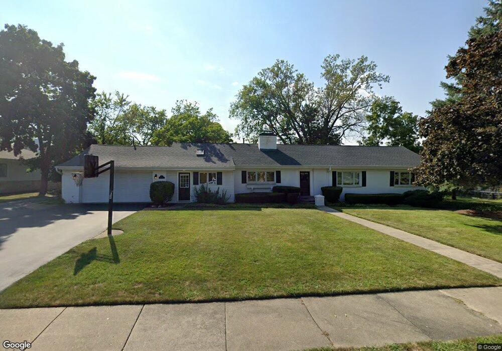
924 Westcliff Ln Deerfield, IL 60015
Briarwood NeighborhoodEstimated Value: $646,599 - $947,000
3
Beds
2
Baths
2,114
Sq Ft
$380/Sq Ft
Est. Value
About This Home
This home is located at 924 Westcliff Ln, Deerfield, IL 60015 and is currently estimated at $802,650, approximately $379 per square foot. 924 Westcliff Ln is a home located in Lake County with nearby schools including Kipling Elementary School, Alan B Shepard Middle School, and Deerfield High School.
Ownership History
Date
Name
Owned For
Owner Type
Purchase Details
Closed on
Apr 27, 1994
Sold by
Lough Linda J and Barrett Linda J
Bought by
Kuczek Theodore D and Kuczek Cheryl J
Current Estimated Value
Create a Home Valuation Report for This Property
The Home Valuation Report is an in-depth analysis detailing your home's value as well as a comparison with similar homes in the area
Home Values in the Area
Average Home Value in this Area
Purchase History
We collect this data history from publicly available records. To have your information removed, we recommend requesting removal directly through your county’s website.
| Date | Buyer | Sale Price | Title Company |
|---|---|---|---|
| Kuczek Theodore D | $178,666 | -- |
Source: Public Records
Tax History
| Year | Tax Paid | Tax Assessment Tax Assessment Total Assessment is a certain percentage of the fair market value that is determined by local assessors to be the total taxable value of land and additions on the property. | Land | Improvement |
|---|---|---|---|---|
| 2025 | $15,981 | $188,997 | $56,478 | $132,519 |
| 2024 | $15,652 | $173,339 | $51,799 | $121,540 |
| 2023 | $18,148 | $166,352 | $49,711 | $116,641 |
| 2022 | $18,148 | $197,583 | $83,296 | $114,287 |
| 2021 | $17,122 | $190,497 | $80,309 | $110,188 |
| 2020 | $16,467 | $190,898 | $80,478 | $110,420 |
| 2019 | $16,096 | $190,574 | $80,341 | $110,233 |
| 2018 | $16,204 | $205,569 | $85,155 | $120,414 |
| 2017 | $16,571 | $204,913 | $84,883 | $120,030 |
| 2016 | $16,118 | $197,164 | $81,673 | $115,491 |
| 2015 | $15,790 | $185,253 | $76,739 | $108,514 |
| 2014 | $13,022 | $151,727 | $77,288 | $74,439 |
| 2012 | $12,706 | $150,388 | $76,606 | $73,782 |
Source: Public Records
Map
Nearby Homes
- 939 Westcliff Ln
- 1008 Oxford Rd
- 1033 Kenton Rd
- 755 Kipling Place
- 1114 Oxford Rd
- 757 Kipling Place
- 980 Brand Ln
- 944 Rosemary Terrace
- 1153 Kenton Rd
- 1148 Kenton Rd
- 860 Heather Rd
- 990 Heather Rd
- 707 Brierhill Rd
- 617 Waukegan Rd
- 1300 Knollwood Rd
- 1311 Carlisle Place
- 1317 Knollwood Rd
- 673 Central Ave
- 527 Cumnor Ct
- 1106 Waukegan Rd
- 917 Oxford Rd
- 931 Oxford Rd
- 912 Westcliff Ln
- 905 Oxford Rd
- 918 Oxford Rd
- 924 Oxford Rd
- 912 Oxford Rd
- 401 Margate Terrace
- 899 Oxford Rd
- 900 Westcliff Ln
- 930 Oxford Rd
- 906 Oxford Rd
- 936 Westcliff Ln
- 938 Oxford Rd
- 900 Oxford Rd
- 921 Westcliff Ln
- 853 Oxford Rd
- 909 Westcliff Ln
- 429 Margate Terrace
- 856 Oxford Rd
Your Personal Tour Guide
Ask me questions while you tour the home.