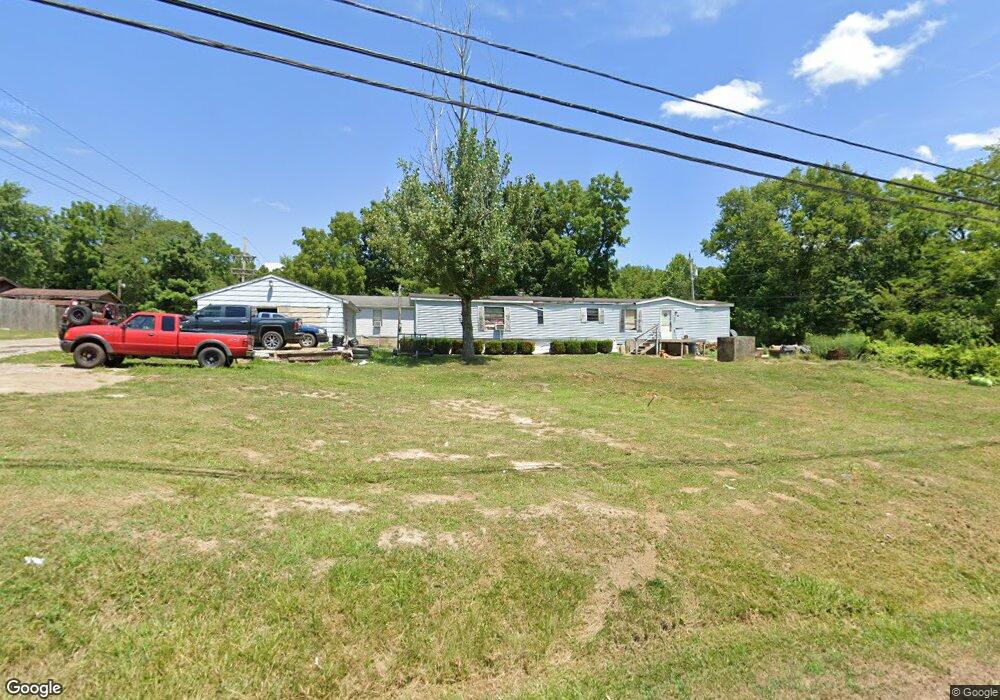
925 E 10th St Wellston, OH 45692
Estimated Value: $76,000 - $116,000
2
Beds
1
Bath
841
Sq Ft
$108/Sq Ft
Est. Value
About This Home
This home is located at 925 E 10th St, Wellston, OH 45692 and is currently estimated at $91,000, approximately $108 per square foot. 925 E 10th St is a home located in Jackson County with nearby schools including Bundy Elementary School, Wellston Intermediate School, and Wellston Middle School.
Ownership History
Date
Name
Owned For
Owner Type
Purchase Details
Closed on
Mar 5, 2008
Sold by
U S Bank N A
Bought by
Summers Joe
Current Estimated Value
Purchase Details
Closed on
Jun 4, 2005
Sold by
Smith Darlane K
Bought by
Cupp Igregor S
Purchase Details
Closed on
Jul 2, 2004
Sold by
Pisavsky John E
Bought by
Cupp George S
Purchase Details
Closed on
Nov 6, 2002
Sold by
Mcclelland Edward C and Mcclelland Ruth
Bought by
Pisavsky John E
Create a Home Valuation Report for This Property
The Home Valuation Report is an in-depth analysis detailing your home's value as well as a comparison with similar homes in the area
Home Values in the Area
Average Home Value in this Area
Purchase History
| Date | Buyer | Sale Price | Title Company |
|---|---|---|---|
| Summers Joe | $6,000 | None Available | |
| U S Bank National Association | -- | Prism Title & Closing Servic | |
| Cupp Igregor S | -- | None Available | |
| Cupp George S | $5,000 | -- | |
| Pisavsky John E | $25,000 | -- |
Source: Public Records
Tax History
| Year | Tax Paid | Tax Assessment Tax Assessment Total Assessment is a certain percentage of the fair market value that is determined by local assessors to be the total taxable value of land and additions on the property. | Land | Improvement |
|---|---|---|---|---|
| 2024 | $2,737 | $4,010 | $4,010 | $0 |
| 2023 | $2,834 | $4,010 | $4,010 | $0 |
| 2022 | $184 | $3,900 | $3,440 | $460 |
| 2021 | $210 | $5,260 | $3,440 | $1,820 |
| 2020 | $215 | $5,260 | $3,440 | $1,820 |
| 2019 | $215 | $5,100 | $3,340 | $1,760 |
| 2018 | $209 | $5,100 | $3,340 | $1,760 |
| 2017 | $200 | $5,100 | $3,340 | $1,760 |
| 2016 | $1,488 | $5,340 | $3,710 | $1,630 |
| 2015 | $211 | $5,340 | $3,710 | $1,630 |
| 2013 | $199 | $5,270 | $3,710 | $1,560 |
| 2012 | $1,486 | $5,270 | $3,710 | $1,560 |
Source: Public Records
Map
Nearby Homes
- 760 S Rhode Island Ave
- 1309 S Maine Ave
- 303 E 9th St
- 1258 S Rhode Island Ave
- 1304 S New Jersey Ave
- 1409 S Massachusetts Ave
- 1254 S New York Ave
- 416 S New York Ave
- 1409 S New Jersey Ave
- 0 Ohio 327
- 1436 S New York Ave
- 1440 S New York Ave
- 224 E 2nd St
- 2417 Glenroy Rd
- 52 W 10th St
- 16 E Broadway St
- 432 S Michigan Ave
- 0 Ohio 93
- 101 E D St
- 0 D St
- 923 E 10th St
- 950 S Maine Ave
- 945 S Maine Ave
- 922 E 10th St
- 943 S Maine Ave
- 1308 Delaware Ave
- Lot 84 Delaware Ave
- 910 E 10th St
- 953 S 10th St
- 621 S Delaware Ave
- 645 S Maine Ave
- 941 S Maine Ave
- 939 S Maine Ave
- 1011 E 10th St
- 635 1/2 S Delaware Ave
- 1009 E 10th St
- 635 S Deleware Ave
- 756 S Rhode Island Ave
- 752 S Rhode Island Ave
- 740 S Rhode Island Ave
Your Personal Tour Guide
Ask me questions while you tour the home.