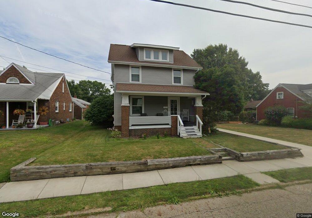
925 E Broad St Louisville, OH 44641
Estimated Value: $179,000 - $200,000
3
Beds
1
Bath
1,644
Sq Ft
$113/Sq Ft
Est. Value
About This Home
This home is located at 925 E Broad St, Louisville, OH 44641 and is currently estimated at $186,151, approximately $113 per square foot. 925 E Broad St is a home located in Stark County with nearby schools including Louisville High School and St. Thomas Aquinas High School & Middle School.
Ownership History
Date
Name
Owned For
Owner Type
Purchase Details
Closed on
Jul 22, 1996
Sold by
Marchbank George G
Bought by
Bell Brad A and Bell Regina
Current Estimated Value
Home Financials for this Owner
Home Financials are based on the most recent Mortgage that was taken out on this home.
Original Mortgage
$68,400
Outstanding Balance
$4,976
Interest Rate
8.31%
Mortgage Type
New Conventional
Estimated Equity
$181,175
Create a Home Valuation Report for This Property
The Home Valuation Report is an in-depth analysis detailing your home's value as well as a comparison with similar homes in the area
Home Values in the Area
Average Home Value in this Area
Purchase History
| Date | Buyer | Sale Price | Title Company |
|---|---|---|---|
| Bell Brad A | $72,000 | -- |
Source: Public Records
Mortgage History
| Date | Status | Borrower | Loan Amount |
|---|---|---|---|
| Open | Bell Brad A | $68,400 |
Source: Public Records
Tax History Compared to Growth
Tax History
| Year | Tax Paid | Tax Assessment Tax Assessment Total Assessment is a certain percentage of the fair market value that is determined by local assessors to be the total taxable value of land and additions on the property. | Land | Improvement |
|---|---|---|---|---|
| 2025 | -- | $46,200 | $11,620 | $34,580 |
| 2024 | -- | $46,200 | $11,620 | $34,580 |
| 2023 | $1,618 | $37,560 | $9,170 | $28,390 |
| 2022 | $1,623 | $37,560 | $9,170 | $28,390 |
| 2021 | $1,627 | $37,560 | $9,170 | $28,390 |
| 2020 | $1,309 | $32,800 | $8,260 | $24,540 |
| 2019 | $1,114 | $27,770 | $8,260 | $19,510 |
| 2018 | $1,110 | $27,770 | $8,260 | $19,510 |
| 2017 | $983 | $23,710 | $6,650 | $17,060 |
| 2016 | $1,003 | $23,710 | $6,650 | $17,060 |
| 2015 | $1,006 | $23,710 | $6,650 | $17,060 |
| 2014 | $976 | $21,390 | $6,020 | $15,370 |
| 2013 | $492 | $21,390 | $6,020 | $15,370 |
Source: Public Records
Map
Nearby Homes
- 520 S Silver St
- 308 Superior St
- 641 S Nickelplate St
- 728 E Broad St
- 204 E Broad St
- 107 E Broad St
- 0 Michigan Blvd
- 1715 High St
- 325 Lincoln Ave
- 1812 E Broad St
- 908 Sand Lot Cir
- 1170 Winding Ridge Ave
- 2015 E Main St
- 910 Crosswyck Cir
- 2110 Edmar St
- 1702 View Pointe Ave
- 428 Honeycrisp Dr NE
- 3047 Mcintosh Dr NE
- 432 Honeycrisp Dr NE
- 2962 Mcintosh Dr NE
- 919 E Broad St
- 1007 E Broad St
- 411 Superior St
- 913 E Broad St
- 1000 Brown Ave
- 917 E Broad St
- 918 E Broad St
- 405 Superior St
- 909 E Broad St
- 912 Brown Ave
- 917 919 E Broad St
- 922 E Broad St
- 926 E Broad St
- 1002 E Broad St
- 408 S Silver St
- 418 S Silver St
- 1003 Brown Ave
- 916 E Broad St
- 400 S Silver St
- 1012 E Broad St