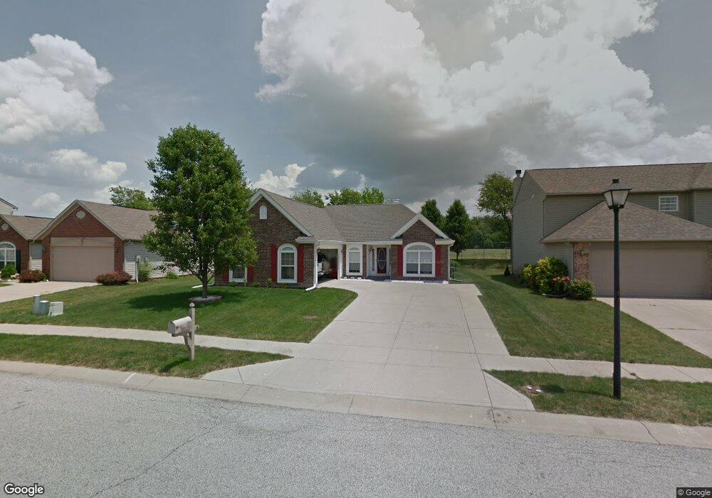
925 Nicole Way Unit 1 Whiteland, IN 46184
Estimated Value: $261,052 - $278,000
3
Beds
2
Baths
1,496
Sq Ft
$180/Sq Ft
Est. Value
About This Home
This home is located at 925 Nicole Way Unit 1, Whiteland, IN 46184 and is currently estimated at $269,013, approximately $179 per square foot. 925 Nicole Way Unit 1 is a home located in Johnson County with nearby schools including Break-O-Day Elementary School, Clark-Pleasant Middle School, and Whiteland Community High School.
Ownership History
Date
Name
Owned For
Owner Type
Purchase Details
Closed on
Jun 23, 2016
Sold by
Cox Thomas E and Cox Sandra E
Bought by
Dunbar Karen K
Current Estimated Value
Home Financials for this Owner
Home Financials are based on the most recent Mortgage that was taken out on this home.
Original Mortgage
$145,500
Outstanding Balance
$116,065
Interest Rate
3.64%
Estimated Equity
$152,948
Create a Home Valuation Report for This Property
The Home Valuation Report is an in-depth analysis detailing your home's value as well as a comparison with similar homes in the area
Home Values in the Area
Average Home Value in this Area
Purchase History
| Date | Buyer | Sale Price | Title Company |
|---|---|---|---|
| Dunbar Karen K | -- | None Available |
Source: Public Records
Mortgage History
| Date | Status | Borrower | Loan Amount |
|---|---|---|---|
| Open | Dunbar Karen K | $145,500 |
Source: Public Records
Tax History Compared to Growth
Tax History
| Year | Tax Paid | Tax Assessment Tax Assessment Total Assessment is a certain percentage of the fair market value that is determined by local assessors to be the total taxable value of land and additions on the property. | Land | Improvement |
|---|---|---|---|---|
| 2025 | $2,345 | $232,800 | $56,000 | $176,800 |
| 2024 | $2,345 | $224,700 | $56,000 | $168,700 |
| 2023 | $2,278 | $218,400 | $56,000 | $162,400 |
| 2022 | $1,932 | $186,800 | $29,900 | $156,900 |
| 2021 | $1,656 | $159,900 | $29,900 | $130,000 |
| 2020 | $1,478 | $142,300 | $29,900 | $112,400 |
| 2019 | $1,362 | $131,400 | $29,900 | $101,500 |
| 2018 | $1,312 | $126,700 | $18,800 | $107,900 |
| 2017 | $1,308 | $128,900 | $18,800 | $110,100 |
| 2016 | $1,244 | $123,400 | $18,800 | $104,600 |
| 2014 | $1,147 | $113,700 | $23,000 | $90,700 |
| 2013 | $1,147 | $116,300 | $23,000 | $93,300 |
Source: Public Records
Map
Nearby Homes
- 12 Rypma Row
- 821 Princeton Dr
- 647 Bluestem Cir
- 731 W 600 N
- 106 Tracy Ridge Blvd
- 143 Tracy Ridge Blvd
- 190 Tracy Ridge Blvd
- 1119 Chateaugay Ct
- Liberty Plan at Crossroads at Southport
- 7331 Deerberg Dr
- Jefferson Plan at Crossroads at Southport
- 7338 Deerberg Dr
- Rushmore Plan at Crossroads at Southport
- Lincoln Plan at Crossroads at Southport
- Washington Plan at Crossroads at Southport
- 76 Fernleaf Dr
- 250 Southlane Dr
- 346 Switchgrass Ln
- 239 Shelton Place
- 0 E 700 N Unit MBR22036500