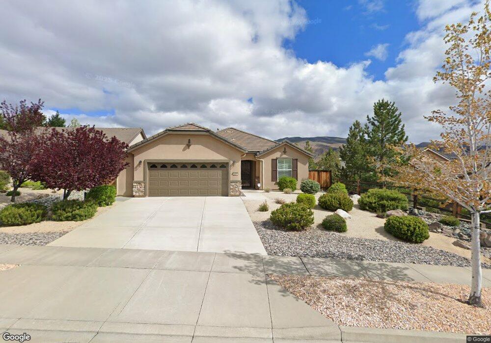
9255 Walking Stick Ct Reno, NV 89523
Somersett NeighborhoodEstimated Value: $614,788 - $652,000
2
Beds
2
Baths
1,644
Sq Ft
$391/Sq Ft
Est. Value
About This Home
This home is located at 9255 Walking Stick Ct, Reno, NV 89523 and is currently estimated at $642,197, approximately $390 per square foot. 9255 Walking Stick Ct is a home located in Washoe County with nearby schools including B D Billinghurst Middle School and Robert McQueen High School.
Ownership History
Date
Name
Owned For
Owner Type
Purchase Details
Closed on
Sep 14, 2010
Sold by
Dolci Michael P and Dolci Carol J
Bought by
Dolci Michael Patrick and Dolci Carol Janet
Current Estimated Value
Purchase Details
Closed on
Nov 12, 2007
Sold by
Pn Ii Inc
Bought by
Dolci Michael P and Dolci Carol J
Home Financials for this Owner
Home Financials are based on the most recent Mortgage that was taken out on this home.
Original Mortgage
$45,000
Interest Rate
6.35%
Mortgage Type
Purchase Money Mortgage
Create a Home Valuation Report for This Property
The Home Valuation Report is an in-depth analysis detailing your home's value as well as a comparison with similar homes in the area
Home Values in the Area
Average Home Value in this Area
Purchase History
| Date | Buyer | Sale Price | Title Company |
|---|---|---|---|
| Dolci Michael Patrick | -- | None Available | |
| Dolci Michael P | $350,000 | First American Title Reno |
Source: Public Records
Mortgage History
| Date | Status | Borrower | Loan Amount |
|---|---|---|---|
| Closed | Dolci Michael P | $45,000 |
Source: Public Records
Tax History Compared to Growth
Tax History
| Year | Tax Paid | Tax Assessment Tax Assessment Total Assessment is a certain percentage of the fair market value that is determined by local assessors to be the total taxable value of land and additions on the property. | Land | Improvement |
|---|---|---|---|---|
| 2026 | -- | $126,798 | $45,500 | $81,298 |
| 2025 | $3,233 | $125,298 | $42,805 | $82,493 |
| 2024 | $3,233 | $119,664 | $36,680 | $82,984 |
| 2023 | $3,138 | $121,523 | $43,190 | $78,333 |
| 2022 | $3,048 | $98,970 | $33,775 | $65,195 |
| 2021 | $2,959 | $90,923 | $26,215 | $64,708 |
| 2020 | $2,870 | $93,111 | $28,385 | $64,726 |
Source: Public Records
Map
Nearby Homes
- 9380 Copper Mountain Cir
- 1405 Meridian Ranch Dr
- 9190 Quilberry Way
- 1380 Wakefield Trail
- 9161 Quilberry Way
- 1240 Cliff Park Way
- 1220 Cliff Park Way
- 1170 Cliff Park Way
- 9225 Sassafras Trail
- 9165 Kenton Trail
- 861 Larrimore Trail
- 1591 Elk Run Trail
- 0 Mountain Daisy Rd
- 0 Mountain Haven Ln
- 1755 Back Nine Trail
- 1590 Scott Valley Rd
- 1671 Crescent Pointe Ct
- 270 Mogul Mountain Dr
- 8139 Dornoch Dr
- 1640 Scott Valley Rd
- 9265 Walking Stick Ct
- 9265 Walking Stick Ct Unit Lot 5208
- 1365 Walking Stick Way
- 1375 Walking Stick Way Unit Lot 55
- 1065 Del Webb Pkwy W
- 1065 Del Webb Pkwy W Unit Lot 87 Village 9 / 5
- 9275 Walking Stick Ct
- 9275 Walking Stick Ct Unit Lot 3408
- 1385 Walking Stick Way
- 1075 Del Webb Pkwy W
- 1075 Del Webb Pkwy W Unit lot 88 V9
- 1085 Del Webb Pkwy W
- 1085 Del Webb Pkwy W Unit Lot 89 V9
- 1395 Walking Stick Way
- 1395 Walking Stick Way Unit lot 5708
- 9220 Walking Stick Ct
- 9230 Walking Stick Ct
- 9285 Walking Stick Ct
- 9210 Walking Stick Ct
- 1095 Del Webb Pkwy W