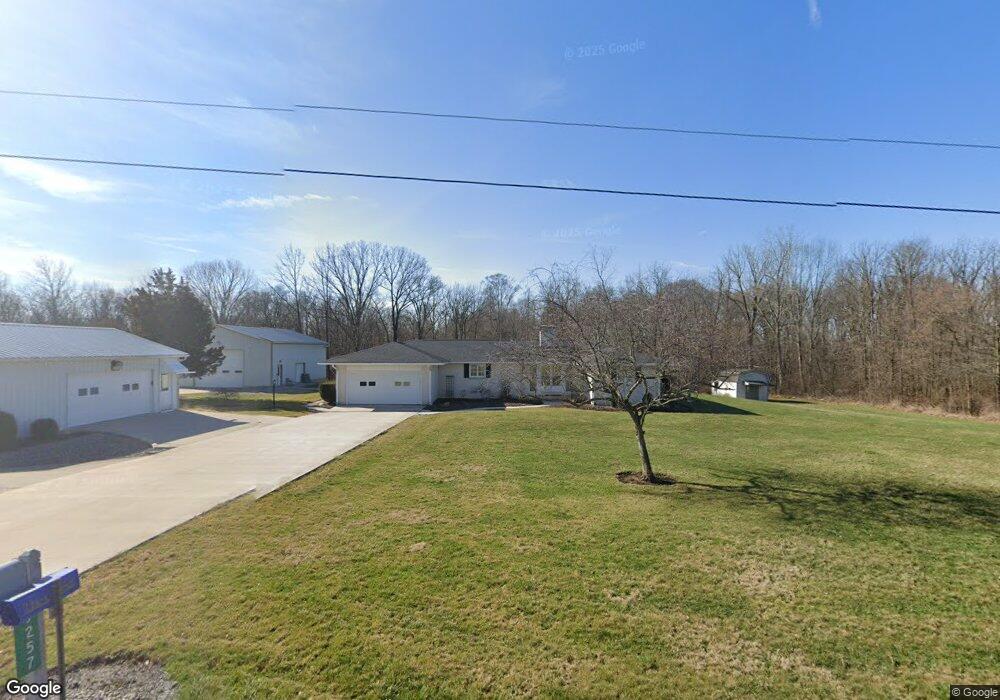
9257 Township Road 94 Findlay, OH 45840
Estimated Value: $321,574 - $515,000
3
Beds
2
Baths
1,747
Sq Ft
$226/Sq Ft
Est. Value
About This Home
This home is located at 9257 Township Road 94, Findlay, OH 45840 and is currently estimated at $394,144, approximately $225 per square foot. 9257 Township Road 94 is a home located in Hancock County with nearby schools including Liberty-Benton Elementary School, Liberty-Benton Middle School, and Liberty-Benton High School.
Ownership History
Date
Name
Owned For
Owner Type
Purchase Details
Closed on
Mar 23, 2012
Sold by
Diller Thomas D and Diller Thomas O
Bought by
Bales Larry N and Bales Laurie J
Current Estimated Value
Home Financials for this Owner
Home Financials are based on the most recent Mortgage that was taken out on this home.
Original Mortgage
$136,000
Outstanding Balance
$93,467
Interest Rate
3.88%
Mortgage Type
New Conventional
Estimated Equity
$300,677
Create a Home Valuation Report for This Property
The Home Valuation Report is an in-depth analysis detailing your home's value as well as a comparison with similar homes in the area
Home Values in the Area
Average Home Value in this Area
Purchase History
| Date | Buyer | Sale Price | Title Company |
|---|---|---|---|
| Bales Larry N | $170,000 | Assured Title |
Source: Public Records
Mortgage History
| Date | Status | Borrower | Loan Amount |
|---|---|---|---|
| Open | Bales Larry N | $136,000 |
Source: Public Records
Tax History Compared to Growth
Tax History
| Year | Tax Paid | Tax Assessment Tax Assessment Total Assessment is a certain percentage of the fair market value that is determined by local assessors to be the total taxable value of land and additions on the property. | Land | Improvement |
|---|---|---|---|---|
| 2024 | $3,267 | $87,720 | $10,620 | $77,100 |
| 2023 | $3,190 | $87,720 | $10,620 | $77,100 |
| 2022 | $3,159 | $87,720 | $10,620 | $77,100 |
| 2021 | $2,632 | $64,510 | $9,360 | $55,150 |
| 2020 | $2,655 | $64,510 | $9,360 | $55,150 |
| 2019 | $2,547 | $64,510 | $9,360 | $55,150 |
| 2018 | $2,093 | $58,470 | $7,800 | $50,670 |
| 2017 | $2,159 | $58,470 | $7,800 | $50,670 |
| 2016 | $2,100 | $58,470 | $7,800 | $50,670 |
| 2015 | $2,386 | $64,950 | $7,800 | $57,150 |
| 2014 | $2,408 | $64,950 | $7,800 | $57,150 |
| 2012 | $2,135 | $55,210 | $7,800 | $47,410 |
Source: Public Records
Map
Nearby Homes
- 8922 Township Road 94
- 0 County Road 140
- 9960 W Us Route 224
- 0 County Road 95 Unit 6097574
- 6535 Silver Lake Dr
- 0 County Road 223
- 8179 Hazelwood Dr
- 1405 Cypress Lake
- 8256 Silverwood Dr
- 3106 Saddlebrook
- 0 Rock Candy Rd Unit Lot 159
- 0 Rock Candy Rd Unit Lot 170
- 0 Rock Candy Rd Unit Lot 172 206819
- 0 Rock Candy Rd Unit Lot 162
- 0 Rock Candy Rd Unit Lot 171
- 0 Rock Candy Rd Unit Lot 168
- 0 Rock Candy Rd Or Bushwillow Dr Unit Lot 173
- 0 Bearcat Way Or Rock Candy Rd Unit Lot 167
- 0 Bushwillow Dr Or Rock Candy Rd Unit Lot 157
- 3018 Gleneagle Dr
- 9303 Township Road 94
- 9197 Township Road 94
- 9250 Township Road 94
- 9147 Township Road 94
- 9367 Township Road 94
- 9133 Township Road 94
- 9407 Township Road 94
- 9100 Township Road 94
- 7037 County Road 139
- 9119 Pierce Dr
- 6887 County Road 139
- 6843 County Road 139
- 9122 Pierce Dr
- 9604 Township Road 94
- 9063 Pierce Dr
- 6850 County Road 139
- 9066 Pierce Dr
- 9177 Township Road 95
- 6788 County Road 139
- 6671 County Road 139