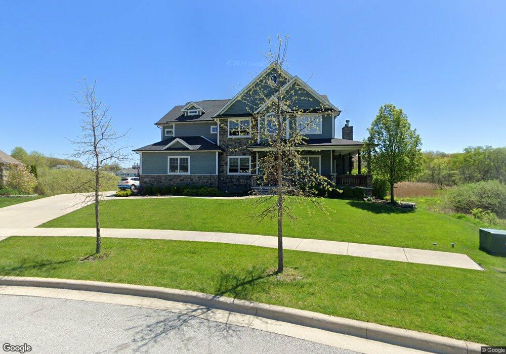
926 Lillian Russell Ct Crown Point, IN 46307
Estimated Value: $547,000 - $729,000
3
Beds
4
Baths
3,191
Sq Ft
$207/Sq Ft
Est. Value
About This Home
This home is located at 926 Lillian Russell Ct, Crown Point, IN 46307 and is currently estimated at $660,093, approximately $206 per square foot. 926 Lillian Russell Ct is a home located in Lake County with nearby schools including Lake Street Elementary School, Robert Taft Middle School, and Crown Point High School.
Ownership History
Date
Name
Owned For
Owner Type
Purchase Details
Closed on
Jun 13, 2019
Sold by
4Greens Llc
Bought by
Vicari Erin
Current Estimated Value
Purchase Details
Closed on
Feb 9, 2015
Sold by
Vicari Erin M
Bought by
Clausen Basil R and Vicari Erin M
Home Financials for this Owner
Home Financials are based on the most recent Mortgage that was taken out on this home.
Original Mortgage
$417,000
Interest Rate
3.66%
Mortgage Type
New Conventional
Create a Home Valuation Report for This Property
The Home Valuation Report is an in-depth analysis detailing your home's value as well as a comparison with similar homes in the area
Home Values in the Area
Average Home Value in this Area
Purchase History
| Date | Buyer | Sale Price | Title Company |
|---|---|---|---|
| Vicari Erin | -- | Northwest Indiana Title | |
| Clausen Basil R | -- | Meridian Title Corp |
Source: Public Records
Mortgage History
| Date | Status | Borrower | Loan Amount |
|---|---|---|---|
| Previous Owner | Clausen Basil R | $417,000 |
Source: Public Records
Tax History Compared to Growth
Tax History
| Year | Tax Paid | Tax Assessment Tax Assessment Total Assessment is a certain percentage of the fair market value that is determined by local assessors to be the total taxable value of land and additions on the property. | Land | Improvement |
|---|---|---|---|---|
| 2024 | $5,798 | $545,500 | $92,400 | $453,100 |
| 2023 | $5,685 | $517,200 | $92,400 | $424,800 |
| 2022 | $5,685 | $506,200 | $92,400 | $413,800 |
| 2021 | $5,592 | $498,000 | $92,000 | $406,000 |
| 2020 | $5,514 | $491,100 | $92,000 | $399,100 |
| 2019 | $5,464 | $482,800 | $92,000 | $390,800 |
| 2018 | $6,962 | $467,200 | $92,000 | $375,200 |
| 2017 | $6,737 | $450,300 | $92,000 | $358,300 |
| 2016 | $6,663 | $440,800 | $92,000 | $348,800 |
| 2014 | $2,286 | $92,000 | $92,000 | $0 |
Source: Public Records
Map
Nearby Homes
- 3709 W 121st Ave
- 804 Shannon Dr
- 1144 Mary Ellen Dr
- 775 Quinlan Ct
- 1140 Hyde Park
- 802 Hayfield Dr
- 1156 Donegal Ln
- 908 Mary Ellen Dr
- 4714 W 121st Ave
- 1002 Gordon Ct
- 312 Fairfield Dr
- 1575 S Feather Rock Dr
- 217 Crestview Ln
- 240 W Greenwood Ave
- 12201 Cedar Lake Rd
- 744 S Court St
- 780 Williams Ct
- 11341 Lakewood St
- 924 W Crestview Ct
- 11531 Westvalley Dr
- 926 Lillian Russell Ct
- 924 Lillian Russell Ct
- 927 Lillian Russell Ct
- 927 Lillian Russell Ct
- 924 Lillian Russell Ct
- 922 Lillian Russell Ct
- 925 Lillian Russell Ct
- 925 Lillian Russell Ct
- 922 Lillian Russell Ct
- 923 Lillian Russell Ct
- 919 Lillian Russell Ct
- 919 Lillian Russell Ct
- 918 Lillian Russell Ct
- 920 Lillian Russell Ct
- 962 Ryan Ct
- 958 Ryan Ct
- 916 Lillian Russell Ct
- 917 Lillian Russell Ct
- Lot 344 Lillian Russell Ct
- Lot 342 Lillian Russell Ct