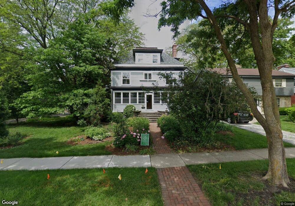
926 Sterling Ave Flossmoor, IL 60422
Estimated Value: $380,000 - $669,000
4
Beds
4
Baths
3,750
Sq Ft
$153/Sq Ft
Est. Value
About This Home
This home is located at 926 Sterling Ave, Flossmoor, IL 60422 and is currently estimated at $572,591, approximately $152 per square foot. 926 Sterling Ave is a home located in Cook County with nearby schools including Western Avenue Elementary School, Parker Junior High School, and Homewood-Flossmoor High School.
Ownership History
Date
Name
Owned For
Owner Type
Purchase Details
Closed on
May 29, 2001
Sold by
Templeton Robert E and Templeton Jeanne M
Bought by
Edelbrock John F and Dalsanto Karen M
Current Estimated Value
Home Financials for this Owner
Home Financials are based on the most recent Mortgage that was taken out on this home.
Original Mortgage
$184,000
Interest Rate
7.18%
Create a Home Valuation Report for This Property
The Home Valuation Report is an in-depth analysis detailing your home's value as well as a comparison with similar homes in the area
Home Values in the Area
Average Home Value in this Area
Purchase History
| Date | Buyer | Sale Price | Title Company |
|---|---|---|---|
| Edelbrock John F | $230,000 | Stewart Title Company |
Source: Public Records
Mortgage History
| Date | Status | Borrower | Loan Amount |
|---|---|---|---|
| Closed | Edelbrock John F | $184,000 |
Source: Public Records
Tax History Compared to Growth
Tax History
| Year | Tax Paid | Tax Assessment Tax Assessment Total Assessment is a certain percentage of the fair market value that is determined by local assessors to be the total taxable value of land and additions on the property. | Land | Improvement |
|---|---|---|---|---|
| 2024 | $10,813 | $31,373 | $4,813 | $26,560 |
| 2023 | $9,848 | $31,373 | $4,813 | $26,560 |
| 2022 | $9,848 | $21,729 | $4,156 | $17,573 |
| 2021 | $9,914 | $21,729 | $4,156 | $17,573 |
| 2020 | $9,615 | $21,729 | $4,156 | $17,573 |
| 2019 | $10,400 | $22,728 | $3,718 | $19,010 |
| 2018 | $10,006 | $22,728 | $3,718 | $19,010 |
| 2017 | $9,854 | $22,728 | $3,718 | $19,010 |
| 2016 | $9,639 | $20,697 | $3,281 | $17,416 |
| 2015 | $10,259 | $21,902 | $3,281 | $18,621 |
| 2014 | $10,094 | $21,902 | $3,281 | $18,621 |
| 2013 | $8,979 | $21,422 | $3,281 | $18,141 |
Source: Public Records
Map
Nearby Homes
- 2622 Central Dr Unit 2N
- 2640 Central Dr Unit 1-N
- 802 Argyle Ave
- 950 Gardner Rd
- 1117 Leavitt Ave Unit 110
- 2633 Hawthorne Ln Unit B
- 846 Park Dr
- 1139 Leavitt Ave Unit 212
- 1139 Leavitt Ave Unit 313
- 1141 Leavitt Ave Unit 115
- 710 Bruce Ave
- 2817 Flossmoor Rd
- 625 Perth Ave
- 926 Braemar Rd
- 2619 Alexander St
- 2929 Flossmoor Rd
- 18530 Stedhall Rd
- 1248 Oakmont Ave
- 18646 Palmer Cir
- 18509 Stedhall Rd
- 926 Sterling Ave
- 932 Sterling Ave
- 938 Sterling Ave
- 919 Argyle Ave
- 942 Sterling Ave
- 929 Argyle Ave
- 914 Sterling Ave
- 907 Argyle Ave
- 905 Argyle Ave
- 935 Argyle Ave
- 912 Sterling Ave
- 912 Sterling Ave
- 945 Argyle Ave
- 851 Argyle Ave
- 908 Sterling Ave
- 918 Argyle Ave
- 926 Argyle Ave
- 908 Argyle Ave
- 845 Argyle Ave
- 932 Argyle Ave