
Seller's Agent in 2023
Deanna Havenner
Century 21 New Millennium
(240) 375-5578
2 in this area
8 Total Sales
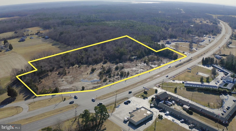


The subject property consists of 10.41 acres. Currently zoned CV Village Commercial, it is the one-time site of the old Earl’s Truck Stop built in the 1950’s. Highly visible location with high traffic count. The property is partially wooded and with scrub hardwood, pine trees and shrubs. Property lines are indicated on the public record’s assessment map. The western property line of approximately nearly 1000 feet runs along northbound lane of Crain Highway. The irregular western border is approximately 750 feet. At the upper northwest corner, the property veers to the west and follows Bel Alton-Newtown Rd for approximately 320 feet. As seen in accompanying photos, evidence of curbing and pavement still exists. The property is improved with a chain link fence on the north, wrapping to northwest border and the old ice building constructed of cinder block. In 2002 the sellers contracted for the removal of the underground storage/gas tanks. See attached letter from MDE certifying the removal of the tanks and satisfactory soil testing
Last Agent to Sell the Property
CENTURY 21 Commercial New Millennium License #109675 Listed on: 11/11/2022
Last Buyer's Agent
CENTURY 21 Commercial New Millennium License #109675 Listed on: 11/11/2022
| Date | Buyer | Sale Price | Title Company |
|---|---|---|---|
| Leo Farm Llc | $300,000 | Bancstar Title | |
| S W Investments Inc | $300,000 | -- | |
| Wechsler, Steven Edward Life Trust | $300,000 | -- |
| Date | Status | Borrower | Loan Amount |
|---|---|---|---|
| Open | Leo Farm Llc | $100,000 | |
| Open | Leo Farm Llc | $320,000 |
| Date | Event | Price | Change | Sq Ft Price |
|---|---|---|---|---|
| 02/10/2023 02/10/23 | Sold | $300,000 | -33.3% | -- |
| 01/29/2023 01/29/23 | Pending | -- | -- | -- |
| 11/11/2022 11/11/22 | For Sale | $450,000 | -- | -- |
| Year | Tax Paid | Tax Assessment Tax Assessment Total Assessment is a certain percentage of the fair market value that is determined by local assessors to be the total taxable value of land and additions on the property. | Land | Improvement |
|---|---|---|---|---|
| 2024 | $3,714 | $282,000 | $282,000 | $0 |
| 2023 | $4,030 | $282,000 | $282,000 | $0 |
| 2022 | $3,715 | $282,000 | $282,000 | $0 |
| 2021 | $3,722 | $282,000 | $282,000 | $0 |
| 2020 | $3,722 | $282,000 | $282,000 | $0 |
| 2019 | $3,726 | $282,000 | $282,000 | $0 |
| 2018 | $3,720 | $282,000 | $282,000 | $0 |
| 2017 | $3,718 | $282,000 | $0 | $0 |
| 2016 | -- | $282,000 | $0 | $0 |
| 2015 | -- | $282,000 | $0 | $0 |
| 2014 | -- | $282,000 | $0 | $0 |
Seller's Agent in 2023
Deanna Havenner
Century 21 New Millennium
(240) 375-5578
2 in this area
8 Total Sales
Seller Co-Listing Agent in 2023
Debra Settle
Century 21 New Millennium
(301) 751-2170
1 in this area
29 Total Sales
Source: Bright MLS
MLS Number: MDCH2018274
APN: 04-001516
Disclaimer: Certain information contained herein is derived from information provided by parties other than Homes.com. All information provided is deemed reliable, but is not guaranteed to be accurate and should be independently verified.
![]() The data relating to real estate for sale on this website appears in part through the BRIGHT Internet Data Exchange program, a voluntary cooperative exchange of property listing data between licensed real estate brokerage firms, and is provided by BRIGHT through a licensing agreement.
The data relating to real estate for sale on this website appears in part through the BRIGHT Internet Data Exchange program, a voluntary cooperative exchange of property listing data between licensed real estate brokerage firms, and is provided by BRIGHT through a licensing agreement.
Listing information is from various brokers who participate in the Bright MLS IDX program and not all listings may be visible on the site.
The property information being provided on or through the website is for the personal, non-commercial use of consumers and such information may not be used for any purpose other than to identify prospective properties consumers may be interested in purchasing.
Some properties which appear for sale on the website may no longer be available because they are for instance, under contract, sold or are no longer being offered for sale.
Property information displayed is deemed reliable but is not guaranteed.
Copyright 2025 Bright MLS, Inc.