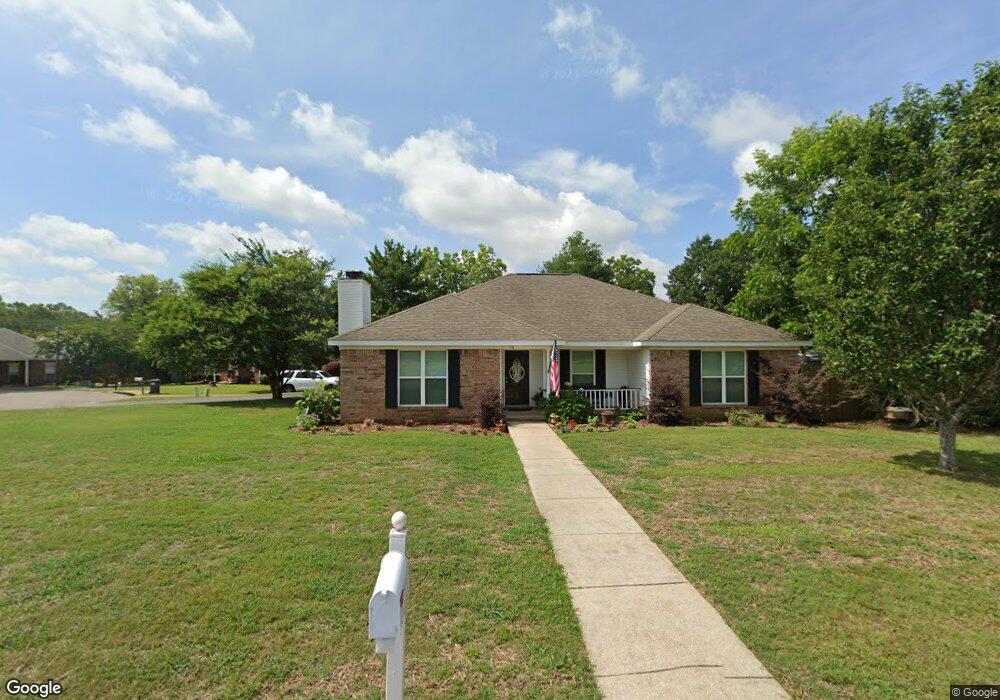
9261 McFarland Trace Dr Mobile, AL 36695
Dawes NeighborhoodEstimated Value: $247,590 - $291,000
3
Beds
2
Baths
1,880
Sq Ft
$147/Sq Ft
Est. Value
About This Home
This home is located at 9261 McFarland Trace Dr, Mobile, AL 36695 and is currently estimated at $276,398, approximately $147 per square foot. 9261 McFarland Trace Dr is a home located in Mobile County with nearby schools including Hutchens Elementary School, Dawes Intermediate School, and Bernice J Causey Middle School.
Ownership History
Date
Name
Owned For
Owner Type
Purchase Details
Closed on
Oct 9, 2001
Sold by
Martin Michael Paul and Martin Vivienne B
Bought by
Harris Robert A and Harris Marna L
Current Estimated Value
Home Financials for this Owner
Home Financials are based on the most recent Mortgage that was taken out on this home.
Original Mortgage
$126,996
Outstanding Balance
$49,638
Interest Rate
6.87%
Mortgage Type
FHA
Estimated Equity
$226,760
Purchase Details
Closed on
Jan 10, 2000
Sold by
Campbell Albert D
Bought by
Martin Michael Paul and Martin Vivienne B
Home Financials for this Owner
Home Financials are based on the most recent Mortgage that was taken out on this home.
Original Mortgage
$121,540
Interest Rate
7.8%
Mortgage Type
VA
Purchase Details
Closed on
Aug 27, 1999
Sold by
Shipman Charles E and Shipman Carol
Bought by
Campbell Albert D
Home Financials for this Owner
Home Financials are based on the most recent Mortgage that was taken out on this home.
Original Mortgage
$60,000
Interest Rate
7.58%
Create a Home Valuation Report for This Property
The Home Valuation Report is an in-depth analysis detailing your home's value as well as a comparison with similar homes in the area
Home Values in the Area
Average Home Value in this Area
Purchase History
| Date | Buyer | Sale Price | Title Company |
|---|---|---|---|
| Harris Robert A | -- | -- | |
| Martin Michael Paul | $118,000 | -- | |
| Campbell Albert D | -- | -- |
Source: Public Records
Mortgage History
| Date | Status | Borrower | Loan Amount |
|---|---|---|---|
| Open | Harris Robert A | $126,996 | |
| Previous Owner | Martin Michael Paul | $121,540 | |
| Previous Owner | Campbell Albert D | $60,000 |
Source: Public Records
Tax History Compared to Growth
Tax History
| Year | Tax Paid | Tax Assessment Tax Assessment Total Assessment is a certain percentage of the fair market value that is determined by local assessors to be the total taxable value of land and additions on the property. | Land | Improvement |
|---|---|---|---|---|
| 2024 | $1,188 | $21,870 | $3,200 | $18,670 |
| 2023 | $945 | $18,380 | $4,000 | $14,380 |
| 2022 | $833 | $18,550 | $4,000 | $14,550 |
| 2021 | $761 | $17,060 | $3,200 | $13,860 |
| 2020 | $782 | $17,500 | $3,200 | $14,300 |
| 2019 | $727 | $16,380 | $0 | $0 |
| 2018 | $741 | $16,660 | $0 | $0 |
| 2017 | $741 | $16,660 | $0 | $0 |
| 2016 | $875 | $19,420 | $0 | $0 |
| 2013 | $776 | $17,240 | $0 | $0 |
Source: Public Records
Map
Nearby Homes
- 0 Mcfarland Rd Unit 380899
- 0 Mcfarland Rd Unit 7600050
- 3582 Magnolia Downs E
- 3658 Dawes Rd
- 3345 Hartsfield Way E
- 3315 Hartsfield Way E
- 9500 Scott Dairy Loop Rd S
- 3330 Woodward Dr
- 2535 Arbordale Loop
- 9206 Champion Hills Cove
- 9497 Labrador Run S
- 3376 Gracie Ln
- 3955 Champion Cir W
- 9581 Estate Dr
- 9457 Labrador Run S Unit 2
- 9085 Johnson Rd S
- 3560 Arlington Oaks Dr
- 9534 Labrador Run N
- 9451 Sir Brutus Run
- 9652 Misty Leaf Dr N
- 3580 McFarland Trace Ct
- 9271 McFarland Trace Dr
- 3570 McFarland Trace Ct
- 9250 McFarland Trace Dr
- 9260 McFarland Trace Dr
- 9240 McFarland Trace Dr
- 9270 McFarland Trace Dr
- 9235 McFarland Trace Dr
- 9281 McFarland Trace Dr
- 3560 McFarland Trace Ct
- 9268 Mcfarland Way
- 9278 Mcfarland Way
- 9230 McFarland Trace Dr
- 9280 McFarland Trace Dr
- 9258 Mcfarland Way
- 9290 McFarland Trace Dr
- 9288 Mcfarland Way
- 9255 Scott Dairy Loop Rd S
- 9265 Scott Dairy Loop Rd S
- 9291 McFarland Trace Dr