


9265 St Route 30 Robertsville, MO 63072
Estimated payment $228/month
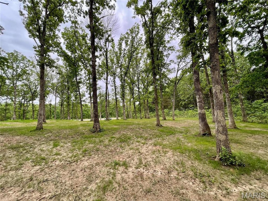
About This Lot
This stunning property located on Gravois Rd is awaiting its new owner. If you're eager to build a home free from the limitations of an HOA, this land is ideal for you! Create your dream home just as you imagine, surrounded by the peaceful beauty of the woods.
Property Details
Property Type
- Land
Est. Annual Taxes
- $159
Lot Details
- 1.8 Acre Lot
- Lot Dimensions are 354x278x301x287
- Property fronts an interstate
- Property is zoned Single-Family
Schools
- Maple Grove Elem. Elementary School
- Northwest Valley Middle School
- Northwest High School
Utilities
- No Utilities
- Not Connected to Water Source
Community Details
- No Home Owners Association
Listing and Financial Details
- Assessor Parcel Number 14-1.0-12.0-0-000-035
Map
Home Values in the Area
Average Home Value in this Area
Tax History
| Year | Tax Paid | Tax Assessment Tax Assessment Total Assessment is a certain percentage of the fair market value that is determined by local assessors to be the total taxable value of land and additions on the property. | Land | Improvement |
|---|---|---|---|---|
| 2024 | $159 | $2,100 | $2,100 | -- |
| 2023 | $159 | $2,100 | $2,100 | $0 |
| 2022 | $158 | $2,100 | $2,100 | $0 |
| 2021 | $157 | $2,100 | $2,100 | $0 |
| 2020 | $131 | $1,700 | $1,700 | $0 |
| 2019 | $131 | $1,700 | $1,700 | $0 |
| 2018 | $131 | $1,700 | $1,700 | $0 |
| 2017 | $124 | $1,700 | $1,700 | $0 |
| 2016 | $124 | $1,700 | $1,700 | $0 |
| 2015 | $110 | $1,700 | $1,700 | $0 |
| 2013 | $110 | $1,600 | $1,600 | $0 |
Property History
| Date | Event | Price | Change | Sq Ft Price |
|---|---|---|---|---|
| 08/12/2025 08/12/25 | Price Changed | $39,500 | -12.2% | -- |
| 07/08/2025 07/08/25 | For Sale | $45,000 | +12.8% | -- |
| 05/23/2025 05/23/25 | Sold | -- | -- | -- |
| 04/22/2025 04/22/25 | For Sale | $39,900 | +320.0% | -- |
| 02/23/2018 02/23/18 | Sold | -- | -- | -- |
| 02/05/2018 02/05/18 | Pending | -- | -- | -- |
| 01/05/2018 01/05/18 | For Sale | $9,500 | -- | -- |
Purchase History
| Date | Type | Sale Price | Title Company |
|---|---|---|---|
| Warranty Deed | -- | Continental Title | |
| Warranty Deed | -- | Investors Title Co | |
| Warranty Deed | -- | Hillsborough Title | |
| Interfamily Deed Transfer | -- | -- |
Mortgage History
| Date | Status | Loan Amount | Loan Type |
|---|---|---|---|
| Previous Owner | $209,700 | New Conventional |
Source: MARIS MLS
MLS Number: MIS25046117
APN: 14-1.0-12.0-0-000-035
Disclaimer: Certain information contained herein is derived from information provided by parties other than Homes.com. All information provided is deemed reliable, but is not guaranteed to be accurate and should be independently verified.
![]() Based on information submitted to the MLS GRID. All data is obtained from various sources and may not have been verified by broker or MLS GRID. Supplied Open House Information is subject to change without notice. All information should be independently reviewed and verified for accuracy. Properties may or may not be listed by the office/agent presenting the information. Some IDX listings have been excluded from this website.
Based on information submitted to the MLS GRID. All data is obtained from various sources and may not have been verified by broker or MLS GRID. Supplied Open House Information is subject to change without notice. All information should be independently reviewed and verified for accuracy. Properties may or may not be listed by the office/agent presenting the information. Some IDX listings have been excluded from this website.
The Digital Millennium Copyright Act of 1998, 17 U.S.C. § 512 (the “DMCA”) provides recourse for copyright owners who believe that material appearing on the Internet infringes their rights under U.S. copyright law. If you believe in good faith that any content or material made available in connection with our website or services infringes your copyright, you (or your agent) may send us a notice requesting that the content or material be removed, or access to it blocked.
Notices must be sent in writing by email to DMCAnotice@MLSGrid.com.
The DMCA requires that your notice of alleged copyright infringement include the following information:
(1) description of the copyrighted work that is the subject of claimed infringement;
(2) description of the alleged infringing content and information sufficient to permit us to locate the content;
(3) contact information for you, including your address, telephone number and email address;
(4) a statement by you that you have a good faith belief that the content in the manner complained of is not authorized by the copyright owner, or its agent, or by the operation of any law;
(5) a statement by you, signed under penalty of perjury, that the information in the notification is accurate and that you have the authority to enforce the copyrights that are claimed to be infringed; and
(6) a physical or electronic signature of the copyright owner or a person authorized to act on the copyright owner’s behalf. Failure to include all of the above information may result in the delay of the processing of your complaint.
- 8165 Whisper Valley Rd
- 10601 Valley Ct
- 8052 County Line Rd
- 0 Zimmerman Rd Unit 11555471
- 0 State Road Ww Unit MAR24031525
- 0 1 + - Acre Hwy 30 Unit MAR25020078
- 0 Joe Buck Unit 24562142
- 0 Joe Buck Unit MIS25058001
- 4423 Project Rd
- 9480 Morse Mill Rd
- 985 Calvey Church Rd
- 0 N Hendricks Rd Unit MAR25021670
- 953 Calvey Church Rd
- 6703 Shenandoah Ln
- 7033 Meadow View Dr
- 6650 Shenandoah Dr
- 9222 Ridge Rd
- 7877 Sylvan Place
- 420 Nancy Dr
- 9318 Morse Mill Rd
- 1001 Brickyard Rd Unit 1
- 313 Cedarview Ct
- 321 Cedarview Ct
- 107 Sandstone Ct
- 111 Sandstone Ct
- 441 Cedarview Ct
- 130 Sandstone Ct
- 128 Sandstone Ct
- 440 Cedarview Ct
- 114 Sandstone Ct
- 716 Tall Oaks Dr Unit multiple units
- 1517 W Pacific St
- 627 Palisades Dr
- 628 Palisades Dr
- 155 Summit Valley Loop
- 990 S Lay Ave
- 3830 Vogt Rd Unit B
- 101 Chapel Ridge Dr
- 400 Legends Terrace Dr
- 400 Legends Terrace Dr Unit 4-305.1411362
