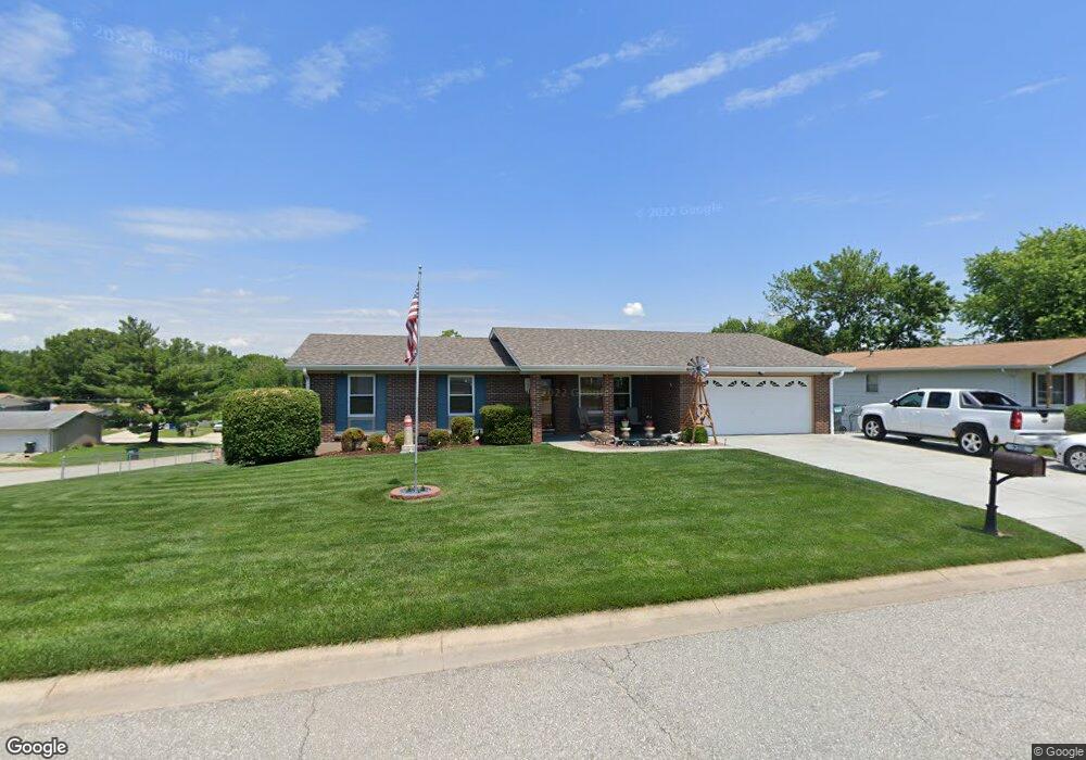
928 Brands Hatch Ln Saint Charles, MO 63303
Heritage NeighborhoodEstimated Value: $294,000 - $318,735
3
Beds
3
Baths
1,318
Sq Ft
$232/Sq Ft
Est. Value
About This Home
This home is located at 928 Brands Hatch Ln, Saint Charles, MO 63303 and is currently estimated at $306,184, approximately $232 per square foot. 928 Brands Hatch Ln is a home located in St. Charles County with nearby schools including Becky-David Elementary School, Barnwell Middle School, and Francis Howell North High School.
Ownership History
Date
Name
Owned For
Owner Type
Purchase Details
Closed on
Mar 17, 2000
Sold by
Borgmeyer Eugene H and Borgmeyer Frances
Bought by
Tanner Craig N and Tanner Lisa J
Current Estimated Value
Home Financials for this Owner
Home Financials are based on the most recent Mortgage that was taken out on this home.
Original Mortgage
$98,900
Outstanding Balance
$33,687
Interest Rate
8.36%
Estimated Equity
$272,497
Create a Home Valuation Report for This Property
The Home Valuation Report is an in-depth analysis detailing your home's value as well as a comparison with similar homes in the area
Home Values in the Area
Average Home Value in this Area
Purchase History
| Date | Buyer | Sale Price | Title Company |
|---|---|---|---|
| Tanner Craig N | $102,000 | -- |
Source: Public Records
Mortgage History
| Date | Status | Borrower | Loan Amount |
|---|---|---|---|
| Open | Tanner Craig N | $98,900 |
Source: Public Records
Tax History Compared to Growth
Tax History
| Year | Tax Paid | Tax Assessment Tax Assessment Total Assessment is a certain percentage of the fair market value that is determined by local assessors to be the total taxable value of land and additions on the property. | Land | Improvement |
|---|---|---|---|---|
| 2025 | $2,930 | $51,543 | -- | -- |
| 2023 | $2,926 | $47,248 | $0 | $0 |
| 2022 | $2,598 | $38,820 | $0 | $0 |
| 2021 | $2,592 | $38,820 | $0 | $0 |
| 2020 | $2,473 | $36,080 | $0 | $0 |
| 2019 | $2,464 | $36,080 | $0 | $0 |
| 2018 | $2,191 | $30,592 | $0 | $0 |
| 2017 | $2,180 | $30,592 | $0 | $0 |
| 2016 | $2,041 | $28,712 | $0 | $0 |
| 2015 | $2,009 | $28,712 | $0 | $0 |
| 2014 | $1,798 | $24,912 | $0 | $0 |
Source: Public Records
Map
Nearby Homes
- 1004 Cobbler Ln
- 2948 Oetting Dr
- 632 Weeping Willow Dr
- 1488 Gettysburg Landing
- 1611 Burnside Ln
- 38 Trailside Ct Unit 3
- 1283 Dell Ridge Ct
- 46 Meadow Run Ct Unit 5
- 1633 Mount Vernon Dr Unit 2
- 3042 Winding River Dr
- 3310 Hampton Crossing
- 1428 Hudson Landing
- 2709 Heritage Landing
- 1350 Spring Park Dr
- 1600 Congress Way
- 506 Newkirk Cir
- 515 Newkirk Cir
- 3150 Arrow Rock Dr
- 17 Stonehenge Ct
- 2738 Cumberland Landing
- 929 Silverstone Dr
- 925 Silverstone Dr
- 2973 Kempton Dr
- 2982 Kempton Dr
- 2977 Kempton Dr
- 920 Brands Hatch Ln
- 927 Brands Hatch Ln
- 937 Silverstone Dr
- 921 Silverstone Dr
- 2981 Kempton Dr
- 923 Brands Hatch Ln
- 916 Brands Hatch Ln
- 917 Silverstone Dr
- 930 Silverstone Dr
- 2976 Brooklands Way
- 2980 Brooklands Way
- 926 Silverstone Dr
- 934 Silverstone Dr
- 930 Mallory Dr
- 919 Brands Hatch Ln