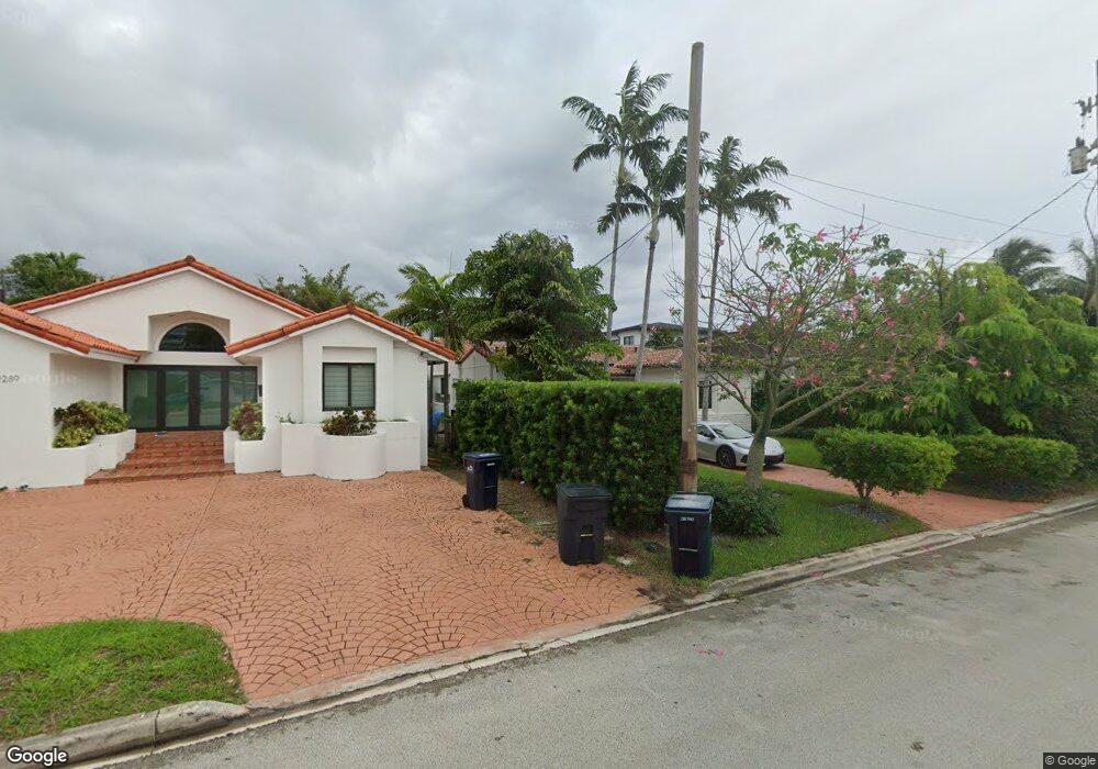
9281 Emerson Ave Surfside, FL 33154
Estimated Value: $1,386,970 - $2,021,000
3
Beds
3
Baths
2,052
Sq Ft
$796/Sq Ft
Est. Value
About This Home
This home is located at 9281 Emerson Ave, Surfside, FL 33154 and is currently estimated at $1,633,743, approximately $796 per square foot. 9281 Emerson Ave is a home located in Miami-Dade County with nearby schools including Ruth K. Broad Bay Harbor K-8 Center, Nautilus Middle School, and Miami Beach Senior High School.
Ownership History
Date
Name
Owned For
Owner Type
Purchase Details
Closed on
May 12, 2021
Sold by
Lampner Gary and Lampner Ann E
Bought by
Lampner Gary D and Lampner Ann E
Current Estimated Value
Purchase Details
Closed on
Jul 15, 1997
Sold by
Kesner Gina
Bought by
Lampner Ary and Lampner Anne E
Home Financials for this Owner
Home Financials are based on the most recent Mortgage that was taken out on this home.
Original Mortgage
$80,000
Interest Rate
7.98%
Mortgage Type
New Conventional
Purchase Details
Closed on
Mar 7, 1997
Sold by
Bettaglio Garcia V De
Bought by
Kesner Gina
Create a Home Valuation Report for This Property
The Home Valuation Report is an in-depth analysis detailing your home's value as well as a comparison with similar homes in the area
Home Values in the Area
Average Home Value in this Area
Purchase History
| Date | Buyer | Sale Price | Title Company |
|---|---|---|---|
| Lampner Gary D | -- | Accommodation | |
| Lampner Ary | $175,000 | -- | |
| Kesner Gina | $120,000 | -- |
Source: Public Records
Mortgage History
| Date | Status | Borrower | Loan Amount |
|---|---|---|---|
| Open | Kesner Gina | $133,000 | |
| Closed | Kesner Gina | $50,000 | |
| Closed | Kesner Gina | $100,000 | |
| Closed | Kesner Gina | $80,000 |
Source: Public Records
Tax History
| Year | Tax Paid | Tax Assessment Tax Assessment Total Assessment is a certain percentage of the fair market value that is determined by local assessors to be the total taxable value of land and additions on the property. | Land | Improvement |
|---|---|---|---|---|
| 2025 | $4,273 | $258,585 | -- | -- |
| 2024 | $4,177 | $251,298 | -- | -- |
| 2023 | $4,177 | $243,979 | $0 | $0 |
| 2022 | $4,057 | $236,873 | $0 | $0 |
| 2021 | $4,020 | $229,974 | $0 | $0 |
| 2020 | $3,997 | $226,799 | $0 | $0 |
| 2019 | $3,913 | $221,700 | $0 | $0 |
| 2018 | $3,763 | $217,567 | $0 | $0 |
| 2017 | $3,730 | $213,093 | $0 | $0 |
| 2016 | $3,745 | $208,711 | $0 | $0 |
| 2015 | $3,782 | $207,261 | $0 | $0 |
| 2014 | $3,818 | $205,617 | $0 | $0 |
Source: Public Records
Map
Nearby Homes
- 9208 Emerson Ave
- 9149 Dickens Ave
- 9148 Carlyle Ave
- 9348 Byron Ave
- 9111 E Bay Harbor Dr Unit PHD
- 9324 Abbott Ave
- 9117 Carlyle Ave
- 9201 E Bay Harbor Dr Unit 702
- 9201 E Bay Harbor Dr Unit 502
- 9201 E Bay Harbor Dr Unit 501
- 9201 E Bay Harbor Dr Unit 804
- 9201 E Bay Harbor Dr Unit 202
- 9201 E Bay Harbor Dr Unit 603
- 9201 E Bay Harbor Dr Unit 604
- 9201 E Bay Harbor Dr Unit UPH02
- 9201 E Bay Harbor Dr Unit LPH_711
- 9201 E Bay Harbor Dr Unit 503
- 9201 E Bay Harbor Dr Unit 805
- 9201 E Bay Harbor Dr Unit 710
- 9201 E Bay Harbor Dr Unit LPH01
- 9273 Emerson Ave
- 9289 Emerson Ave
- 9265 Emerson Ave
- 9289 Dickens Ave
- 9281 Dickens Ave
- 9280 Dickens Ave
- 700 93rd St
- 9272 Dickens Ave
- 9257 Emerson Ave
- 924 93rd St
- 9257 Bay Dr
- 9257 Bay Dr
- 725 93rd St
- 9256 Dickens Ave
- 9249 Emerson Ave
- 9280 Bay Dr Unit 27
- 9280 Bay Dr
- 9288 Bay Dr
- 9270 Bay Dr
- 9248 Emerson Ave
Your Personal Tour Guide
Ask me questions while you tour the home.