
Seller's Agent in 2025
Monica Thrasher
Capstone Realty
(256) 694-4079
5 in this area
72 Total Sales

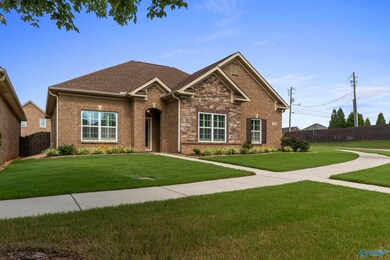
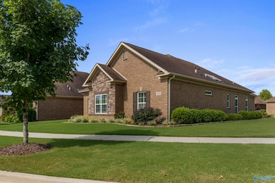
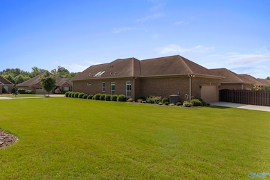

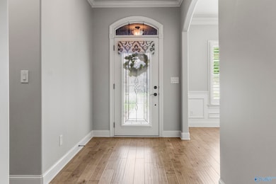

Discover luxury living in this beautifully upgraded single-story Woodland Homes floorplan in the highly sought-after Overland Cove community. This lovely home features hand-scraped hardwood floors, custom cabinetry, quartz countertops, plantation blinds and oversized bedrooms. The kitchen is equipped with a 5-burner cooktop, trash compactor, tiled backsplash and spacious cabinets with pull out drawers. Retreat to the serene primary suite with a spa-inspired bathroom showcasing a zero-entry tiled shower, sky lights, and a fully customized walk-in closet designed to impress. Enjoy year-round comfort in the heated/cooled sunroom or step outside to a beautifully landscaped and fenced backyard.
Last Agent to Sell the Property
Capstone Realty License #000082891 Listed on: 07/11/2025
| Date | Type | Sale Price | Title Company |
|---|---|---|---|
| Warranty Deed | $424,900 | None Listed On Document | |
| Warranty Deed | $100 | None Available | |
| Warranty Deed | $272,559 | None Available | |
| Warranty Deed | $56,900 | None Available | |
| Deed | $192,600 | None Available |
| Date | Status | Loan Amount | Loan Type |
|---|---|---|---|
| Open | $339,920 | New Conventional |
| Date | Event | Price | List to Sale | Price per Sq Ft |
|---|---|---|---|---|
| 09/02/2025 09/02/25 | Sold | $424,900 | 0.0% | $192 / Sq Ft |
| 08/13/2025 08/13/25 | Pending | -- | -- | -- |
| 07/11/2025 07/11/25 | For Sale | $424,900 | -- | $192 / Sq Ft |
| Year | Tax Paid | Tax Assessment Tax Assessment Total Assessment is a certain percentage of the fair market value that is determined by local assessors to be the total taxable value of land and additions on the property. | Land | Improvement |
|---|---|---|---|---|
| 2025 | $1,699 | $33,420 | $6,000 | $27,420 |
| 2024 | $1,699 | $33,420 | $6,000 | $27,420 |
| 2023 | $1,699 | $33,420 | $6,000 | $27,420 |
| 2022 | $1,510 | $29,740 | $5,500 | $24,240 |
| 2021 | $1,380 | $27,220 | $5,500 | $21,720 |
| 2020 | $1,331 | $26,270 | $5,500 | $20,770 |
| 2019 | $1,331 | $26,270 | $5,500 | $20,770 |
| 2018 | $1,331 | $26,280 | $0 | $0 |
| 2017 | $1,215 | $24,020 | $0 | $0 |
| 2016 | $510 | $8,800 | $0 | $0 |
| 2015 | $510 | $8,800 | $0 | $0 |
Seller's Agent in 2025
Monica Thrasher
Capstone Realty
(256) 694-4079
5 in this area
72 Total Sales
Seller Co-Listing Agent in 2025
Sandy Leakeas
Capstone Realty
(256) 975-3059
4 in this area
40 Total Sales
Buyer's Agent in 2025
Kristan Stanton
RE/MAX
(256) 303-9096
7 in this area
135 Total Sales
Source: ValleyMLS.com
MLS Number: 21893919
APN: 15-06-13-0-000-057.166
Disclaimer: Certain information contained herein is derived from information provided by parties other than Homes.com. All information provided is deemed reliable, but is not guaranteed to be accurate and should be independently verified.
![]() Properties marked with this icon are provided courtesy of the Valley MLS IDX Database. Some or all of the listings displayed may not belong to the firm whose website is being visited.
Properties marked with this icon are provided courtesy of the Valley MLS IDX Database. Some or all of the listings displayed may not belong to the firm whose website is being visited.
All information provided is deemed reliable but is not guaranteed and should be independently verified.
Copyright 2025 Valley MLS