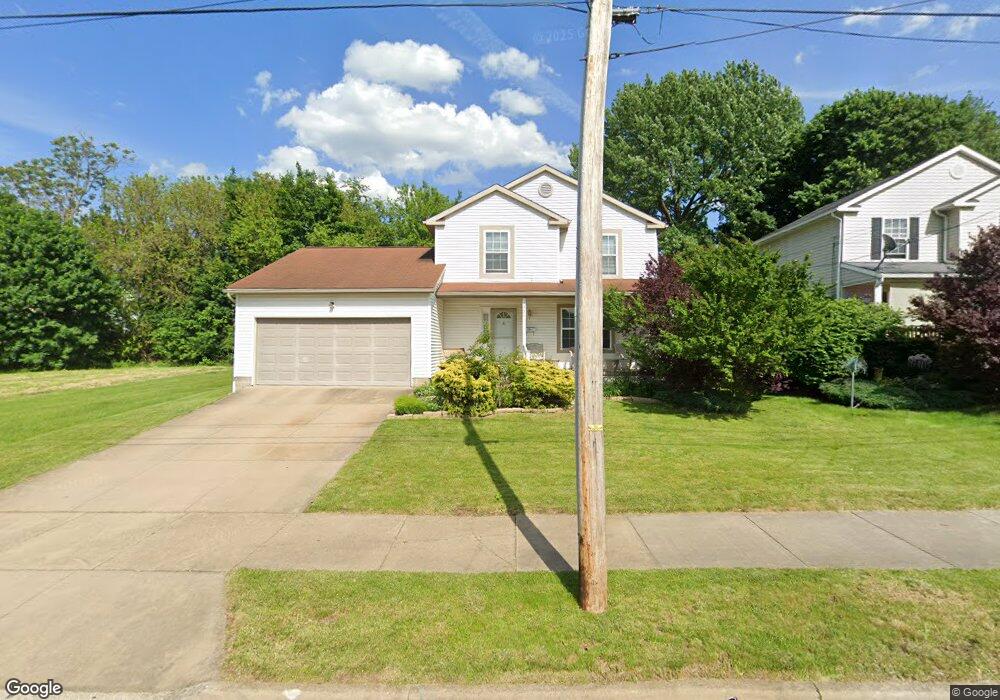
929 Moeller Ave Akron, OH 44307
Sherbondy Hill NeighborhoodEstimated Value: $93,853 - $161,000
3
Beds
2
Baths
1,466
Sq Ft
$87/Sq Ft
Est. Value
About This Home
This home is located at 929 Moeller Ave, Akron, OH 44307 and is currently estimated at $126,963, approximately $86 per square foot. 929 Moeller Ave is a home located in Summit County with nearby schools including St. Bernard-St. Mary Elementary School.
Ownership History
Date
Name
Owned For
Owner Type
Purchase Details
Closed on
Jul 11, 2003
Sold by
Urban Neighborhood Development Corp
Bought by
Lewis Donny L
Current Estimated Value
Home Financials for this Owner
Home Financials are based on the most recent Mortgage that was taken out on this home.
Original Mortgage
$82,400
Interest Rate
5.62%
Mortgage Type
Purchase Money Mortgage
Purchase Details
Closed on
Oct 25, 2002
Sold by
The Urban Neighborhood Development Corp
Bought by
The Urban Neighborhood Development Corp
Create a Home Valuation Report for This Property
The Home Valuation Report is an in-depth analysis detailing your home's value as well as a comparison with similar homes in the area
Home Values in the Area
Average Home Value in this Area
Purchase History
| Date | Buyer | Sale Price | Title Company |
|---|---|---|---|
| Lewis Donny L | $85,000 | Land America/Lawyers Title | |
| The Urban Neighborhood Development Corp | -- | Endress/Lawyers Title |
Source: Public Records
Mortgage History
| Date | Status | Borrower | Loan Amount |
|---|---|---|---|
| Previous Owner | Lewis Donny L | $82,400 | |
| Closed | Lewis Donny L | $5,000 |
Source: Public Records
Tax History Compared to Growth
Tax History
| Year | Tax Paid | Tax Assessment Tax Assessment Total Assessment is a certain percentage of the fair market value that is determined by local assessors to be the total taxable value of land and additions on the property. | Land | Improvement |
|---|---|---|---|---|
| 2025 | $697 | $20,441 | $3,959 | $16,482 |
| 2024 | $697 | $20,441 | $3,959 | $16,482 |
| 2023 | $697 | $20,441 | $3,959 | $16,482 |
| 2022 | $367 | $12,541 | $2,331 | $10,210 |
| 2021 | $367 | $12,541 | $2,331 | $10,210 |
| 2020 | $364 | $12,540 | $2,330 | $10,210 |
| 2019 | $537 | $14,640 | $1,800 | $12,840 |
| 2018 | $439 | $13,350 | $1,800 | $11,550 |
| 2017 | $468 | $13,350 | $1,800 | $11,550 |
| 2016 | $468 | $13,690 | $1,800 | $11,890 |
| 2015 | $468 | $13,690 | $1,800 | $11,890 |
| 2014 | $465 | $13,690 | $1,800 | $11,890 |
| 2013 | $614 | $15,970 | $1,800 | $14,170 |
Source: Public Records
Map
Nearby Homes
- 677 Vernon Odom Blvd
- 949 Raymond St
- 1132 Bristol Terrace
- 385 Campbell St
- 737 Vernon Odom Blvd
- 817 Raymond St
- 639 Bellevue Ave
- 650 Easter Ave
- 702 W Thornton St
- 776 Krause Ct
- 985 Diana Ave
- 263 Millcreek Dr Unit 263
- 670 Euclid Ave
- 1174 La Croix Ave
- 834 Kenyon St
- 1302 East Ave
- 783 Boulevard St
- 738 Longview Ave
- 699 Fultz St
- 815 Sheridan St