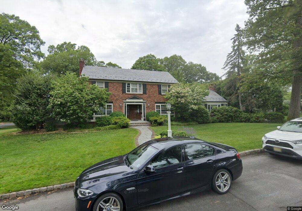
93 Colt Rd Summit, NJ 07901
Estimated Value: $2,056,180 - $2,533,000
Studio
--
Bath
3,068
Sq Ft
$763/Sq Ft
Est. Value
About This Home
This home is located at 93 Colt Rd, Summit, NJ 07901 and is currently estimated at $2,340,545, approximately $762 per square foot. 93 Colt Rd is a home located in Union County with nearby schools including L C Johnson Summit Middle School, Summit Sr High School, and Oak Knoll School of the Holy Child.
Ownership History
Date
Name
Owned For
Owner Type
Purchase Details
Closed on
Jun 26, 2007
Sold by
Merritt Raymond W and Merritt Anne R
Bought by
Veloso Virgilio R and Veloso Michelle M
Current Estimated Value
Home Financials for this Owner
Home Financials are based on the most recent Mortgage that was taken out on this home.
Original Mortgage
$500,000
Outstanding Balance
$406,412
Interest Rate
6.39%
Mortgage Type
Credit Line Revolving
Estimated Equity
$1,934,133
Purchase Details
Closed on
Apr 6, 2001
Sold by
Brown F Jeannette and Brown John M
Bought by
Brown F Jeannette
Purchase Details
Closed on
Jul 19, 1996
Sold by
Brown John M and Jeannette Brown F
Bought by
Brown John M and Jeannette Brown F
Create a Home Valuation Report for This Property
The Home Valuation Report is an in-depth analysis detailing your home's value as well as a comparison with similar homes in the area
Home Values in the Area
Average Home Value in this Area
Purchase History
We collect this data history from publicly available records. To have your information removed, we recommend requesting removal directly through your county’s website.
| Date | Buyer | Sale Price | Title Company |
|---|---|---|---|
| Veloso Virgilio R | $1,671,000 | None Available | |
| Brown F Jeannette | -- | -- | |
| Brown John M | -- | -- |
Source: Public Records
Mortgage History
We collect this data history from publicly available records. To have your information removed, we recommend requesting removal directly through your county’s website.
| Date | Status | Borrower | Loan Amount |
|---|---|---|---|
| Open | Veloso Virgilio R | $500,000 | |
| Open | Veloso Virgilio R | $1,000,000 |
Source: Public Records
Tax History
| Year | Tax Paid | Tax Assessment Tax Assessment Total Assessment is a certain percentage of the fair market value that is determined by local assessors to be the total taxable value of land and additions on the property. | Land | Improvement |
|---|---|---|---|---|
| 2025 | $28,588 | $656,300 | $306,200 | $350,100 |
| 2024 | $28,398 | $656,300 | $306,200 | $350,100 |
| 2023 | $28,398 | $656,300 | $306,200 | $350,100 |
| 2022 | $28,109 | $656,300 | $306,200 | $350,100 |
| 2021 | $28,332 | $656,300 | $306,200 | $350,100 |
| 2020 | $28,615 | $656,300 | $306,200 | $350,100 |
| 2019 | $28,311 | $648,600 | $306,200 | $342,400 |
| 2018 | $28,130 | $648,600 | $306,200 | $342,400 |
| 2017 | $28,311 | $648,600 | $306,200 | $342,400 |
| 2016 | $31,926 | $742,300 | $306,200 | $436,100 |
| 2015 | $31,303 | $742,300 | $306,200 | $436,100 |
| 2014 | $30,494 | $742,300 | $306,200 | $436,100 |
Source: Public Records
Map
Nearby Homes
- 29 Knob Hill Dr
- 175 Division Ave
- 22 Brook Hollow Ln
- 19 Greenbriar Dr
- 226 Mountain Ave
- 18 Devon Rd
- 84 Pine Grove Ave
- 65 Division Ave
- 27 Hillside Terrace
- 71 Dale Dr
- 23 Club Dr
- 4 Parkview Terrace
- 718 Springfield Ave
- 738 A Springfield Ave
- 709 Springfield Ave Unit 4
- 167 Mountain Ave
- 120 Brookside Dr
- 852 Springfield Ave
- 777 Springfield Ave Unit 1
- 16 Fairview Ave
Your Personal Tour Guide
Ask me questions while you tour the home.