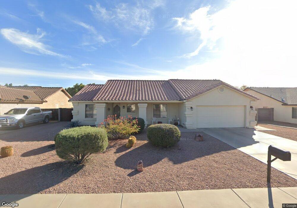
93 E 14th Ave Apache Junction, AZ 85119
Estimated Value: $409,000 - $456,000
Studio
--
Bath
1,559
Sq Ft
$279/Sq Ft
Est. Value
About This Home
This home is located at 93 E 14th Ave, Apache Junction, AZ 85119 and is currently estimated at $434,342, approximately $278 per square foot. 93 E 14th Ave is a home located in Pinal County with nearby schools including Peralta Trail Elementary School, Cactus Canyon Junior High School, and Apache Junction High School.
Ownership History
Date
Name
Owned For
Owner Type
Purchase Details
Closed on
Jun 9, 2023
Sold by
Glynn Family Living Trust
Bought by
Donald Gene Glynn Living Trust
Current Estimated Value
Purchase Details
Closed on
Mar 15, 2017
Sold by
Glynn Donald G and Glynn Ruby A
Bought by
Glynn Donald and Glynn Ruby
Purchase Details
Closed on
Jun 20, 2014
Sold by
Malek Jane F and Austin Delores A
Bought by
Glynn Donald D and Glynn Ruby A
Home Financials for this Owner
Home Financials are based on the most recent Mortgage that was taken out on this home.
Original Mortgage
$149,600
Interest Rate
4.17%
Mortgage Type
New Conventional
Purchase Details
Closed on
Oct 17, 2001
Sold by
Eagle Alliance Inc
Bought by
Malek Jane F and Austin Delores A
Create a Home Valuation Report for This Property
The Home Valuation Report is an in-depth analysis detailing your home's value as well as a comparison with similar homes in the area
Home Values in the Area
Average Home Value in this Area
Purchase History
| Date | Buyer | Sale Price | Title Company |
|---|---|---|---|
| Donald Gene Glynn Living Trust | -- | None Listed On Document | |
| Glynn Donald | -- | None Available | |
| Glynn Donald D | $187,000 | Chicago Title Agency Inc | |
| Malek Jane F | $142,457 | First American Title |
Source: Public Records
Mortgage History
| Date | Status | Borrower | Loan Amount |
|---|---|---|---|
| Previous Owner | Glynn Donald D | $149,600 |
Source: Public Records
Tax History
| Year | Tax Paid | Tax Assessment Tax Assessment Total Assessment is a certain percentage of the fair market value that is determined by local assessors to be the total taxable value of land and additions on the property. | Land | Improvement |
|---|---|---|---|---|
| 2025 | $1,625 | $37,516 | -- | -- |
| 2024 | $1,527 | $39,478 | -- | -- |
| 2023 | $1,599 | $25,204 | $1,679 | $23,525 |
| 2022 | $1,527 | $18,944 | $1,679 | $17,265 |
| 2021 | $1,575 | $16,908 | $0 | $0 |
| 2020 | $1,536 | $16,216 | $0 | $0 |
| 2019 | $1,470 | $15,542 | $0 | $0 |
| 2018 | $1,438 | $14,318 | $0 | $0 |
| 2017 | $1,402 | $13,511 | $0 | $0 |
| 2016 | $1,359 | $13,585 | $1,679 | $11,906 |
Source: Public Records
Map
Nearby Homes
- 30 E 14th Ave
- 1358 W Kowa Cir Unit 358
- 120 W 14th Ave
- 1328 W Inuit Ave
- 1315 W Chesapeake Ave Unit 315
- 1340 W Inuit Ave
- 1495 S Apache Dr
- 1431 S Apache Dr
- 1357 S Kiowa Cir Unit 357
- 1001 Kiowa Cir
- 1177 Kiowa Cir Unit 177
- 1135 S Sioux Dr
- 1306 W Chesapeake Dr
- 1087 S Shoshone Dr Unit 87
- 1127 S Shawnee Dr
- 1843 S Papago Dr
- 1139 Sioux Dr Unit 139
- 1157 Sioux Dr Unit 157
- 1041 Cheyenne Dr Unit 41
- 445 E Hondo Ave
Your Personal Tour Guide
Ask me questions while you tour the home.