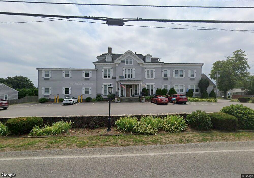
93 Miantonomi Ave Middletown, RI 02842
Estimated Value: $3,129,694
--
Bed
--
Bath
15,600
Sq Ft
$201/Sq Ft
Est. Value
About This Home
This home is located at 93 Miantonomi Ave, Middletown, RI 02842 and is currently estimated at $3,129,694, approximately $200 per square foot. 93 Miantonomi Ave is a home located in Newport County with nearby schools including Middletown High School, St Michael's Country Day School, and All Saints STEAM Academy.
Ownership History
Date
Name
Owned For
Owner Type
Purchase Details
Closed on
Aug 30, 1999
Sold by
Carriage House Nursing
Bought by
Kyriakedes and Kyriakede
Current Estimated Value
Purchase Details
Closed on
Aug 15, 1988
Sold by
Bayview Nursing Hom
Bought by
Carriage Nursing Home
Create a Home Valuation Report for This Property
The Home Valuation Report is an in-depth analysis detailing your home's value as well as a comparison with similar homes in the area
Home Values in the Area
Average Home Value in this Area
Purchase History
| Date | Buyer | Sale Price | Title Company |
|---|---|---|---|
| Kyriakedes | $600,000 | -- | |
| Carriage Nursing Home | $872,000 | -- |
Source: Public Records
Mortgage History
| Date | Status | Borrower | Loan Amount |
|---|---|---|---|
| Open | Carriage Nursing Home | $500,000 | |
| Open | Carriage Nursing Home | $2,650,000 | |
| Closed | Carriage Nursing Home | $1,000,000 |
Source: Public Records
Tax History Compared to Growth
Tax History
| Year | Tax Paid | Tax Assessment Tax Assessment Total Assessment is a certain percentage of the fair market value that is determined by local assessors to be the total taxable value of land and additions on the property. | Land | Improvement |
|---|---|---|---|---|
| 2024 | $31,501 | $2,426,900 | $1,071,400 | $1,355,500 |
| 2023 | $39,719 | $2,124,000 | $737,300 | $1,386,700 |
| 2022 | $37,913 | $2,124,000 | $737,300 | $1,386,700 |
| 2021 | $36,597 | $2,124,000 | $737,300 | $1,386,700 |
| 2020 | $38,578 | $2,118,500 | $641,200 | $1,477,300 |
| 2018 | $38,557 | $2,118,500 | $641,200 | $1,477,300 |
| 2016 | $38,493 | $1,883,200 | $457,100 | $1,426,100 |
| 2015 | $37,589 | $1,883,200 | $457,100 | $1,426,100 |
| 2014 | $41,199 | $1,930,600 | $485,500 | $1,445,100 |
| 2013 | $40,292 | $1,930,600 | $485,500 | $1,445,100 |
Source: Public Records
Map
Nearby Homes
- 203 N Fenner Ave Unit 5
- 117 W Main Rd
- 7 Caswell Ave
- 36 Willow Ave
- 23 Bedlow Ave
- 44 Dudley Ave
- 36 Kay Blvd
- 1 Arnold Ave
- 67 Linden St
- 55 John Clarke Rd Unit 8
- 55 John Clarke Rd Unit 3
- 155 Evarts St
- 5 Gardiner St
- 125 Van Zandt Ave Unit 307
- 129 Bliss Mine Rd
- 39 Powel Ave Unit CH
- 39 Powel Ave Unit 2
- 39 Powel Ave Unit 1
- 78 Ellery Rd
- 7 Sheffield Ave
- 105 Miantonomi Ave
- 149 Fenner Ave
- 1 Farnum Terrace
- 139 Fenner Ave
- 79 Miantonomi Ave
- 158 Fenner Ave
- 109 Miantonomi Ave
- 150 Fenner Ave
- 80 Miantonomi Ave
- 3 Farnum Terrace
- 115 Miantonomi Ave
- 71 Miantonomi Ave
- 5 Farnum Terrace
- 142 Fenner Ave
- 7 Farnum Terrace
- 136 Fenner Ave
- 133 Miantonomi Ave
- 63 Miantonomi Ave
- 47 Livingston Place
- 78 Phelps Rd Unit C