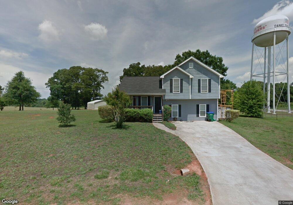
93 Mulberry Ln Danielsville, GA 30633
Estimated Value: $257,132 - $296,000
--
Bed
2
Baths
1,300
Sq Ft
$210/Sq Ft
Est. Value
About This Home
This home is located at 93 Mulberry Ln, Danielsville, GA 30633 and is currently estimated at $273,533, approximately $210 per square foot. 93 Mulberry Ln is a home located in Madison County with nearby schools including Madison County High School.
Ownership History
Date
Name
Owned For
Owner Type
Purchase Details
Closed on
May 20, 2005
Sold by
Dove Anthony
Bought by
Smith Sandra
Current Estimated Value
Home Financials for this Owner
Home Financials are based on the most recent Mortgage that was taken out on this home.
Original Mortgage
$101,437
Outstanding Balance
$52,550
Interest Rate
5.74%
Estimated Equity
$220,983
Purchase Details
Closed on
Aug 30, 2004
Sold by
Minish Paul
Bought by
James R Hunter Construction Inc
Purchase Details
Closed on
Jan 1, 1988
Bought by
Minish Paul
Create a Home Valuation Report for This Property
The Home Valuation Report is an in-depth analysis detailing your home's value as well as a comparison with similar homes in the area
Home Values in the Area
Average Home Value in this Area
Purchase History
| Date | Buyer | Sale Price | Title Company |
|---|---|---|---|
| Smith Sandra | -- | -- | |
| James R Hunter Construction Inc | $82,000 | -- | |
| Minish Paul | -- | -- |
Source: Public Records
Mortgage History
| Date | Status | Borrower | Loan Amount |
|---|---|---|---|
| Open | Smith Sandra | $101,437 |
Source: Public Records
Tax History Compared to Growth
Tax History
| Year | Tax Paid | Tax Assessment Tax Assessment Total Assessment is a certain percentage of the fair market value that is determined by local assessors to be the total taxable value of land and additions on the property. | Land | Improvement |
|---|---|---|---|---|
| 2024 | $2,714 | $87,398 | $11,200 | $76,198 |
| 2023 | $3,015 | $82,373 | $11,200 | $71,173 |
| 2022 | $2,327 | $73,356 | $11,200 | $62,156 |
| 2021 | $1,875 | $52,987 | $11,200 | $41,787 |
| 2020 | $2,037 | $57,166 | $11,200 | $45,966 |
| 2019 | $1,748 | $48,836 | $8,000 | $40,836 |
| 2018 | $1,703 | $47,475 | $8,000 | $39,475 |
| 2017 | $1,670 | $48,788 | $8,000 | $40,788 |
| 2016 | $1,420 | $42,739 | $8,000 | $34,739 |
| 2015 | $1,319 | $45,939 | $11,200 | $34,739 |
| 2014 | $1,298 | $45,166 | $11,200 | $33,966 |
| 2013 | -- | $45,166 | $11,200 | $33,966 |
Source: Public Records
Map
Nearby Homes
- 155 Mulberry Ln
- 170 Northridge Dr
- 150 Northridge Dr Unit 3
- 150 Northridge Dr
- 140 Northridge Dr
- 140 Northridge Dr Unit 6
- 112 Northridge Dr Unit 8
- 112 Northridge Dr
- 96 Northridge Dr Unit 10
- 96 Northridge Dr
- 49 Ridgeway Dr
- 28 Acres Irvin Kirk Rd
- 235 Long Estates Dr
- 0 New Haven Church Rd Unit CL334534
- 0 New Haven Church Rd Unit 10566118
- 0 New Haven Church Rd Unit CL334526
- 0 New Haven Church Rd Unit 10566119
- 105 Georgia 98
- 0 Veterans Dr Unit 10462425
- 0 Veterans Dr Unit 10462434
- 113 Mulberry Ln
- 0 Mulberry Ln Unit CM171501
- 0 Mulberry Ln Unit 934570
- 0 Mulberry Ln Unit 7512803
- 0 Mulberry Ln Unit 8353455
- 0 Mulberry Ln Unit 7142120
- 135 Mulberry Ln
- 138 Northridge Place
- 221 Edgewood Dr
- 144 Northridge Place
- 135 Northridge Place
- 602 Crawford W Long St
- 0 Edgewood Dr Unit 7389610
- 0 Edgewood Dr Unit 8575023
- 0 Edgewood Dr Unit 8687430
- 155 Edgewood Dr
- 155 Edgewood Dr Unit 1
- W Crawford W Long St
- 115 Northridge Place
- 580 Crawford W Long St