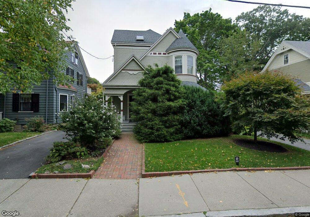
93 Toxteth St Brookline, MA 02446
Coolidge Corner NeighborhoodEstimated Value: $2,174,000 - $3,103,000
5
Beds
3
Baths
2,766
Sq Ft
$956/Sq Ft
Est. Value
About This Home
This home is located at 93 Toxteth St, Brookline, MA 02446 and is currently estimated at $2,644,034, approximately $955 per square foot. 93 Toxteth St is a home located in Norfolk County with nearby schools including Amos A. Lawrence School, Brookline High School, and St. Mary of the Assumption Elementary School.
Ownership History
Date
Name
Owned For
Owner Type
Purchase Details
Closed on
Jul 30, 1997
Sold by
Vanentine A L
Bought by
Alhadeff Peter and Alhadeff Beate
Current Estimated Value
Home Financials for this Owner
Home Financials are based on the most recent Mortgage that was taken out on this home.
Original Mortgage
$350,000
Outstanding Balance
$52,507
Interest Rate
7.55%
Mortgage Type
Purchase Money Mortgage
Estimated Equity
$2,591,527
Create a Home Valuation Report for This Property
The Home Valuation Report is an in-depth analysis detailing your home's value as well as a comparison with similar homes in the area
Home Values in the Area
Average Home Value in this Area
Purchase History
| Date | Buyer | Sale Price | Title Company |
|---|---|---|---|
| Alhadeff Peter | $660,000 | -- |
Source: Public Records
Mortgage History
| Date | Status | Borrower | Loan Amount |
|---|---|---|---|
| Open | Alhadeff Peter | $213,000 | |
| Closed | Alhadeff Peter | $227,150 | |
| Open | Alhadeff Peter | $350,000 |
Source: Public Records
Tax History
| Year | Tax Paid | Tax Assessment Tax Assessment Total Assessment is a certain percentage of the fair market value that is determined by local assessors to be the total taxable value of land and additions on the property. | Land | Improvement |
|---|---|---|---|---|
| 2025 | $23,906 | $2,422,100 | $1,185,700 | $1,236,400 |
| 2024 | $22,739 | $2,327,400 | $1,140,100 | $1,187,300 |
| 2023 | $20,766 | $2,082,800 | $942,500 | $1,140,300 |
| 2022 | $20,213 | $1,983,600 | $897,600 | $1,086,000 |
| 2021 | $18,692 | $1,907,300 | $863,100 | $1,044,200 |
| 2020 | $17,143 | $1,814,100 | $784,700 | $1,029,400 |
| 2019 | $16,189 | $1,727,700 | $747,300 | $980,400 |
| 2018 | $15,486 | $1,637,000 | $597,800 | $1,039,200 |
| 2017 | $15,259 | $1,544,400 | $564,000 | $980,400 |
| 2016 | $14,796 | $1,420,000 | $527,100 | $892,900 |
| 2015 | $13,695 | $1,282,300 | $447,800 | $834,500 |
| 2014 | $13,961 | $1,225,700 | $407,100 | $818,600 |
Source: Public Records
Map
Nearby Homes
- 61 Toxteth St
- 15 Kent Square
- 65 Francis St Unit A
- 81 Francis St Unit 2
- 15 Francis St Unit 16
- 216 Aspinwall Ave
- 216 Aspinwall Ave Unit 3
- 57 Saint Paul St Unit 19
- 37 Saint Paul St Unit 3
- 106 Brook St
- 36 Saint Paul St Unit B
- 14 Linden Place Unit 3
- 2-14 Saint Paul St Unit 403
- 6 Parkway Rd Unit 6
- 63 Longwood Ave Unit 2
- 131 Sewall Ave Unit 61
- 14 Linden St Unit 8
- 60 Longwood Ave Unit 802
- 60 Longwood Ave Unit 307
- 45 Longwood Ave Unit 712
- 97 Toxteth St
- 87 Toxteth St
- 85 Toxteth St
- 52 Harrison St
- 48 Harrison St
- 48 Harrison St Unit 1
- 54 Harrison St Unit 56
- 44 Harrison St Unit 2
- 44 Harrison St Unit 1
- 44 Harrison St Unit 1,44
- 81 Toxteth St
- 81 Toxteth St
- 81 Toxteth St Unit 1
- 60 Harrison St Unit 2
- 60 Harrison St Unit 1
- 98 Toxteth St Unit 6
- 98 Toxteth St Unit 2
- 98 Toxteth St
- 98 Toxteth St Unit 3
- 90 Toxteth St Unit 92
Your Personal Tour Guide
Ask me questions while you tour the home.