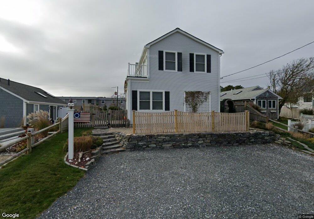
93 Uncle Rolf Rd Dennis Port, MA 02639
Dennis Port NeighborhoodEstimated Value: $574,000 - $899,000
2
Beds
2
Baths
1,505
Sq Ft
$506/Sq Ft
Est. Value
About This Home
This home is located at 93 Uncle Rolf Rd, Dennis Port, MA 02639 and is currently estimated at $762,078, approximately $506 per square foot. 93 Uncle Rolf Rd is a home located in Barnstable County with nearby schools including Dennis-Yarmouth Regional High School and St. Pius X. School.
Ownership History
Date
Name
Owned For
Owner Type
Purchase Details
Closed on
Aug 27, 2021
Sold by
Lowrie Stephen J and Lowrie Ericka B
Bought by
Lowrie Ft
Current Estimated Value
Purchase Details
Closed on
Mar 5, 2004
Sold by
J & J Rt
Bought by
Lowrie Ericka B and Lowrie Stephen J
Create a Home Valuation Report for This Property
The Home Valuation Report is an in-depth analysis detailing your home's value as well as a comparison with similar homes in the area
Home Values in the Area
Average Home Value in this Area
Purchase History
| Date | Buyer | Sale Price | Title Company |
|---|---|---|---|
| Lowrie Ft | -- | None Available | |
| Lowrie Ericka B | $319,000 | -- |
Source: Public Records
Tax History Compared to Growth
Tax History
| Year | Tax Paid | Tax Assessment Tax Assessment Total Assessment is a certain percentage of the fair market value that is determined by local assessors to be the total taxable value of land and additions on the property. | Land | Improvement |
|---|---|---|---|---|
| 2025 | $3,193 | $737,500 | $302,500 | $435,000 |
| 2024 | $3,274 | $745,700 | $290,900 | $454,800 |
| 2023 | $3,187 | $682,400 | $264,500 | $417,900 |
| 2022 | $3,161 | $564,400 | $249,300 | $315,100 |
| 2021 | $3,231 | $535,900 | $244,400 | $291,500 |
| 2020 | $3,002 | $492,100 | $271,600 | $220,500 |
| 2019 | $2,971 | $481,500 | $266,300 | $215,200 |
| 2018 | $2,547 | $401,800 | $212,900 | $188,900 |
| 2017 | $2,472 | $401,900 | $213,000 | $188,900 |
| 2016 | $2,308 | $353,500 | $207,900 | $145,600 |
| 2015 | $2,262 | $353,500 | $207,900 | $145,600 |
| 2014 | $2,276 | $358,500 | $202,800 | $155,700 |
Source: Public Records
Map
Nearby Homes
- 112 Old Wharf Rd Unit E4
- 112 Old Wharf Rd Unit E1
- 64 Beaten Rd
- 120 Old Wharf Rd Unit 11
- 154 Old Wharf Rd Unit 26
- 154 Old Wharf Rd Unit 14
- 37 Ocean Dr Unit 2
- 217 Old Wharf Rd Unit 64
- 241 Old Wharf Rd Unit 82
- 241 Old Wharf Rd Unit 127
- 241 Old Wharf Rd Unit 90
- 262 Old Wharf Rd Unit 67
- 262 Old Wharf Rd Unit 5
- 262 Old Wharf Rd Unit 5
- 262 Old Wharf Rd Unit 20
- 262 Old Wharf Rd Unit 87
- 37 Beach Hills Rd
- 37-A Beach Hills Rd
- 80 Michaels Ave
- 31 Easy St
- 91 Uncle Rolf Rd
- 95 Uncle Rolf Rd
- 95 Uncle Rolf Rd Unit 1
- 87 Uncle Rolf Rd
- 97 Uncle Rolf Rd
- 89 Uncle Rolf Rd
- 96 Uncle Rolf Rd
- 94 Uncle Rolf Rd
- 85 Uncle Rolf Rd
- 14 Uncle Rolf Rd
- 99 Uncle Rolf Rd Unit 14
- 99 Uncle Rolf Rd
- 100 Uncle Rolf Rd
- 90 Uncle Rolf Rd
- 89,89A Uncle Rolf
- 83 Uncle Rolf Rd
- 104 Uncle Rolf Rd
- 88 Bain Rd
- 88 Uncle Rolf Rd
- 18 Old Wharf Rd