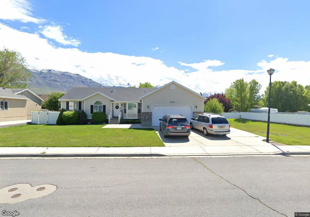
930 N 1700 W Pleasant Grove, UT 84062
Estimated Value: $590,000 - $629,000
1
Bed
2
Baths
1,692
Sq Ft
$361/Sq Ft
Est. Value
About This Home
This home is located at 930 N 1700 W, Pleasant Grove, UT 84062 and is currently estimated at $610,451, approximately $360 per square foot. 930 N 1700 W is a home located in Utah County with nearby schools including Mount Mahogany School, Pleasant Grove Junior High School, and Pleasant Grove High School.
Ownership History
Date
Name
Owned For
Owner Type
Purchase Details
Closed on
Aug 17, 2020
Sold by
Harradine Peter J and Harradine Lisa A
Bought by
Harradine Peter and Harradine Lisa Ann
Current Estimated Value
Home Financials for this Owner
Home Financials are based on the most recent Mortgage that was taken out on this home.
Original Mortgage
$350,000
Outstanding Balance
$248,521
Interest Rate
3%
Mortgage Type
New Conventional
Estimated Equity
$361,930
Purchase Details
Closed on
Feb 28, 2012
Sold by
Kemp Richard
Bought by
Harman David R
Purchase Details
Closed on
Jun 10, 2003
Sold by
Kemp Dale R
Bought by
Kemp Richard
Home Financials for this Owner
Home Financials are based on the most recent Mortgage that was taken out on this home.
Original Mortgage
$164,000
Interest Rate
5.5%
Mortgage Type
Purchase Money Mortgage
Create a Home Valuation Report for This Property
The Home Valuation Report is an in-depth analysis detailing your home's value as well as a comparison with similar homes in the area
Home Values in the Area
Average Home Value in this Area
Purchase History
| Date | Buyer | Sale Price | Title Company |
|---|---|---|---|
| Harradine Peter | -- | Eagle Gate Title Ins Agcy In | |
| Harman David R | -- | Union Title | |
| Kemp Richard | -- | Capitol Title |
Source: Public Records
Mortgage History
| Date | Status | Borrower | Loan Amount |
|---|---|---|---|
| Open | Harradine Peter | $350,000 | |
| Previous Owner | Kemp Richard | $164,000 | |
| Closed | Kemp Richard | $41,000 |
Source: Public Records
Tax History Compared to Growth
Tax History
| Year | Tax Paid | Tax Assessment Tax Assessment Total Assessment is a certain percentage of the fair market value that is determined by local assessors to be the total taxable value of land and additions on the property. | Land | Improvement |
|---|---|---|---|---|
| 2025 | $2,340 | $318,945 | $237,100 | $342,800 |
| 2024 | $2,340 | $279,235 | $0 | $0 |
| 2023 | $2,259 | $275,990 | $0 | $0 |
| 2022 | $2,480 | $301,510 | $0 | $0 |
| 2021 | $2,177 | $403,000 | $148,800 | $254,200 |
| 2020 | $1,994 | $361,900 | $132,900 | $229,000 |
| 2019 | $1,845 | $346,300 | $117,300 | $229,000 |
| 2018 | $1,771 | $314,300 | $109,500 | $204,800 |
| 2017 | $1,622 | $153,175 | $0 | $0 |
| 2016 | $1,564 | $142,615 | $0 | $0 |
| 2015 | $1,451 | $125,345 | $0 | $0 |
| 2014 | $1,445 | $123,640 | $0 | $0 |
Source: Public Records
Map
Nearby Homes
- 1515 W 1010 St N
- 1541 W 1060 N
- 1491 W 1010 N
- 1443 W 1010 N
- 1498 W 1060 N Unit 5
- Lytham Plan at Grove Acres
- 1065 N 1420 W
- 1879 W 1100 N
- 1096 N 1420 St W Unit 27
- 759 W 930 N Unit 502
- 708 W 930 N Unit 505
- 734 W 930 N Unit 506
- 1171 N 1430 W
- 1598 W 220 N
- 293 N 1630 W
- 1141 E 50 N
- 295 N 1580 W
- 1525 W 300 N
- 1088 E 390 S
- 152 S 930 E