
Seller's Agent in 2022
Michael Talbott
Berkshire Hathaway Cooper & Co
(251) 367-2767
1 in this area
4 Total Sales
Estimated Value: $194,000 - $196,000
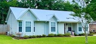
The exterior of this home features a new durable, energy-efficient metal roof with the gutter system installed less than one year ago. Newly painted exterior, an easy maintenance front landscape. Large privacy fenced backyard. Inside: 3Br 2Ba with new flooring in living area/hallway. Ceramic tiled in the fully functional kitchen with plenty of counter space and white cabinetry. Breakfast/dining nook with a bay window view. Home is located close to schools, shopping, and the airport.
Last Agent to Sell the Property
Berkshire Hathaway Cooper & Co License #50878 Listed on: 05/31/2022
| Date | Buyer | Sale Price | Title Company |
|---|---|---|---|
| Williams Van | $175,000 | None Listed On Document | |
| Cunningham Rimanda N | $119,900 | Dst | |
| Boutwell Meredith B | -- | Surety Land Title Inc | |
| Forwood Brothers Rentals Llc | -- | -- |
| Date | Status | Borrower | Loan Amount |
|---|---|---|---|
| Open | Williams Van | $171,830 | |
| Previous Owner | Cunningham Rimanda N | $117,727 | |
| Previous Owner | Boutwell Meredith B | $86,443 | |
| Previous Owner | Forwood Brothers Rentals Llc | $65,600 |
| Date | Event | Price | List to Sale | Price per Sq Ft |
|---|---|---|---|---|
| 07/11/2022 07/11/22 | Sold | $175,000 | +2.9% | $138 / Sq Ft |
| 06/02/2022 06/02/22 | Pending | -- | -- | -- |
| 05/31/2022 05/31/22 | For Sale | $170,000 | -- | $134 / Sq Ft |
| Year | Tax Paid | Tax Assessment Tax Assessment Total Assessment is a certain percentage of the fair market value that is determined by local assessors to be the total taxable value of land and additions on the property. | Land | Improvement |
|---|---|---|---|---|
| 2025 | $821 | $16,850 | $3,000 | $13,850 |
| 2024 | $821 | $15,880 | $3,000 | $12,880 |
| 2023 | $773 | $13,830 | $3,300 | $10,530 |
| 2022 | $421 | $10,050 | $3,000 | $7,050 |
| 2021 | $426 | $10,160 | $2,400 | $7,760 |
| 2020 | $426 | $10,160 | $2,400 | $7,760 |
| 2019 | $429 | $10,220 | $0 | $0 |
| 2018 | $391 | $9,440 | $0 | $0 |
| 2017 | $472 | $9,680 | $0 | $0 |
| 2016 | $425 | $10,140 | $0 | $0 |
| 2013 | $515 | $9,520 | $0 | $0 |
Seller's Agent in 2022
Michael Talbott
Berkshire Hathaway Cooper & Co
(251) 367-2767
1 in this area
4 Total Sales
Buyer's Agent in 2022
Kimberly Curtis
IXL Real Estate LLC
(404) 271-4543
1 in this area
10 Total Sales
Source: Gulf Coast MLS (Mobile Area Association of REALTORS®)
MLS Number: 7057200
APN: 27-08-27-0-000-070.007
Disclaimer: Certain information contained herein is derived from information provided by parties other than Homes.com. All information provided is deemed reliable, but is not guaranteed to be accurate and should be independently verified.
![]() IDX information is provided exclusively for personal, non-commercial use, and may not be used for any purpose other than to identify prospective properties consumers may be interested in purchasing. Information is deemed reliable but not guaranteed.
IDX information is provided exclusively for personal, non-commercial use, and may not be used for any purpose other than to identify prospective properties consumers may be interested in purchasing. Information is deemed reliable but not guaranteed.
Ask me questions while you tour the home.